RoadDrive
AboutApp StoreSign In / Up

Zion Canyon Loop

Zion Canyon Loop
Zion Canyon Visitor Center
United States
271 km
4h 6m

Where Temples of Stone Touch the Heavens

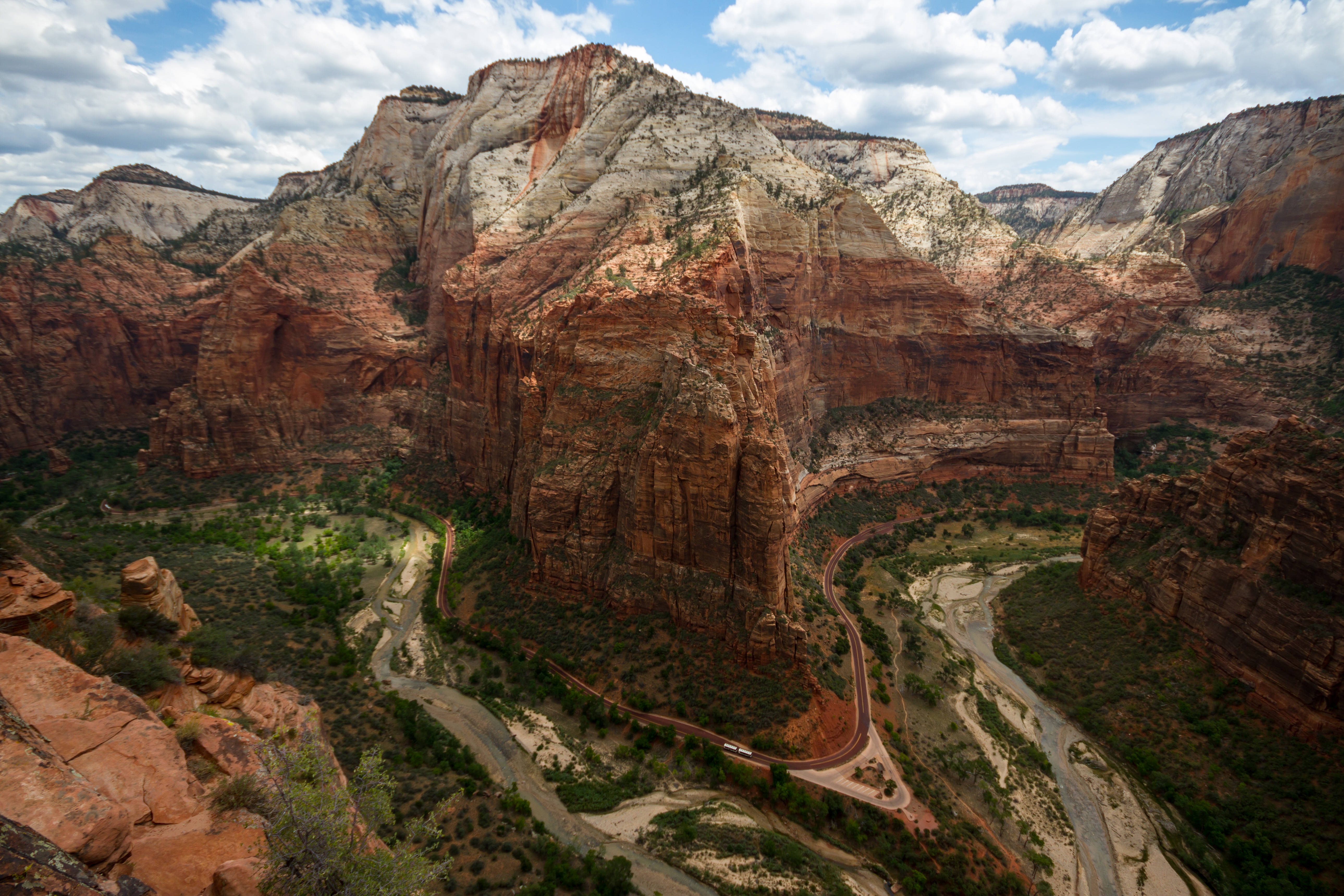
Zion Canyon is a cathedral of stone carved over millions of years by the Virgin River through 2,000-foot walls of Navajo sandstone that glow salmon, ivory, and vermilion in the shifting light. The 7.7-mile Zion Canyon Scenic Drive threads the canyon floor beneath monoliths so immense that early Mormon settlers named them temples, thrones, and altars — the Court of the Patriarchs, the Great White Throne, Angels Landing, the Temple of Sinawava. From March through November, the road is closed to private vehicles and served by a free shuttle that stops at nine points along the Virgin River, each one a gateway to trails ranging from paved strolls to waist-deep river wading through The Narrows. The broader Zion Canyon Loop — a 270-mile circuit through southwest Utah — extends east through the engineering marvel of the Zion–Mt. Carmel Tunnel, south past Coral Pink Sand Dunes, north along the Markagunt Scenic Byway to Cedar Breaks National Monument, and back through the remote Kolob Canyons, completing a grand tour of some of the most dramatic geology in the American West.


Key Stops

Zion Canyon Visitor Center Start here to orient yourself. The center is open year-round and offers ranger programs, interactive exhibits on the park's geology and ecology, a bookstore, and the shuttle departure point. The adjacent Watchman Trailhead and Pa'rus Trail — Zion's only path open to bicycles and leashed pets — begin steps away, following the Virgin River 3.5 miles north with views of the Watchman and Towers of the Virgin.

Court of the Patriarchs (Shuttle Stop 3) A very short 0.1-mile paved walk from the shuttle leads to a viewpoint beneath three towering sandstone peaks named Abraham, Isaac, and Jacob. Morning light is best, illuminating the red-gold faces of the patriarchs against deep blue sky. The surrounding cottonwood groves along the Virgin River turn brilliant gold in October.

Zion Lodge (Shuttle Stop 5) The only lodging inside the park, set among cottonwoods on the canyon floor. The Red Rock Grill serves breakfast, lunch, and dinner with canyon views (reservations recommended). From here, the Lower Emerald Pool Trail (1.2 miles round trip, paved) leads to a dripping alcove and reflecting pool beneath a sandstone overhang. The Upper Emerald Pool Trail continues 3 miles round trip to a deeper grotto. Note: the Middle Emerald Pool Trail is closed indefinitely due to landslide damage.

The Grotto (Shuttle Stop 6) The trailhead for Angels Landing, one of America's most famous hikes. The 5.4-mile round trip climbs 1,488 feet through Walter's Wiggles — 21 tight switchbacks — to Scout Lookout, then traverses a narrow ridge with chain handholds and 1,000-foot drop-offs to a summit with 360-degree canyon views. A permit is now required for the chain section: apply through Recreation.gov via a seasonal lottery (quarterly) or a day-before lottery. The application fee is $6 plus $3 per person if awarded.

Weeping Rock (Shuttle Stop 7) This short 0.4-mile paved trail leads to an alcove where water that seeped into the sandstone plateau 1,200 years ago emerges as a curtain of dripping springs. Hanging gardens of columbine and maidenhair fern cling to the damp rock face. The nearby Hidden Canyon and East Rim trails remain closed long-term due to rockfall.

Big Bend (Shuttle Stop 8) The best roadside vantage point for the Great White Throne — a colossal mass of Navajo sandstone with a flat, pale crown that sparkles in the sun, rising 2,400 feet above the canyon floor. Angels Landing's sheer western face is also dramatically visible from here. This is a favorite spot for rock climbers to scout routes and for photographers to capture the canyon's scale at golden hour.

Temple of Sinawava (Shuttle Stop 9) The end of the road and the beginning of The Narrows. The paved 1-mile Riverside Walk follows the Virgin River to a point where the canyon walls close to just 20 feet apart and the trail becomes the river itself. From here, hikers wade upstream through waist-deep water between soaring 1,500-foot walls in one of the world's great slot canyon experiences. No permit is needed for the bottom-up day hike, but the trail closes when river flow exceeds 150 CFS or during flash flood warnings. The top-down through-hike (16 miles) requires a wilderness permit — 40 issued daily.

Zion–Mt. Carmel Tunnel Heading east on UT-9, the road zigzags up from the canyon floor and enters a 1.1-mile tunnel blasted through solid Navajo sandstone in 1930 — a marvel of Depression-era engineering. Window-like openings carved into the rock offer dramatic glimpses of the canyon below. Just east of the tunnel, the Canyon Overlook Trail (1-mile round trip) provides commanding views of Pine Creek Canyon and the Great Arch of Zion. Beyond the tunnel, the landscape shifts to petrified sand dunes and the crosshatched Checkerboard Mesa. Note: from June 7, 2026, oversized vehicles (over 35'9" long, 7'10" wide, or 11'4" tall) will be banned entirely from this road.

Cedar Breaks National Monument (Full Loop) On the broader 270-mile loop via the Markagunt Scenic Byway (UT-14), this 2,500-foot-deep, three-mile-wide amphitheater at over 10,000 feet elevation rivals Bryce Canyon in color and surpasses it in solitude. Four overlooks line the five-mile park road, each revealing a kaleidoscope of oranges and reds deepened by long evening shadows. Bristlecone pines up to 1,600 years old cling to the rim. The road is closed mid-November to late May due to snow.

Kolob Canyons (Northwest Section) Accessed from I-15 Exit 40, roughly 40 miles from the main entrance, this remote corner of Zion is a world apart. A 5.5-mile paved road winds through the Finger Canyons — long, narrow sandstone ridges separated by deep gorges of crimson and cream. The Taylor Creek Middle Fork Trail (5 miles round trip) passes two historic cabins and a natural double arch. Seven miles by trail from the road lies Kolob Arch, one of the world's largest freestanding natural arches at 310 feet. The road is currently partially closed at Taylor Creek Trailhead due to a collapsed section — check conditions before visiting.

Grafton Ghost Town South of UT-9 near Rockville, an unpaved road leads to the haunting remains of this 1850s settlement, abandoned by the early 1900s after the settlers were defeated by drought, flood, and conflict. The weathered buildings served as the backdrop for the bicycle scene in Butch Cassidy and the Sundance Kid. A short, atmospheric walk-through frontier history with Zion's towers as a backdrop.


Driving Tips

  • Shuttle required: Private vehicles are not permitted on Zion Canyon Scenic Drive from March through November. The free shuttle runs every few minutes from the Visitor Center; no reservation needed. In winter (roughly December–February), you may drive the canyon road yourself.
  • Angels Landing permit: You cannot hike past Scout Lookout without a permit. Apply via Recreation.gov — either the seasonal lottery (quarterly, ranked-choice for up to 7 dates) or the day-before lottery (apply by 3 PM, notified by 4 PM). Plan well ahead for peak season.
  • The Narrows safety: Check the Virgin River flow gauge before entering. The hike closes at 150 CFS. Flash floods are life-threatening — never enter during rain or storm forecasts, especially July–September. Rent canyoneering shoes and neoprene socks in Springdale; the river bottom is slippery cobble.
  • Springdale shuttle: A free town shuttle connects Springdale's hotels and restaurants to the park's pedestrian entrance. A new Park & Ride at Virgin (Zion White Bison Resort, $5/ride) opened March 2026 for those wanting to avoid Springdale parking.
  • Tunnel restrictions: The Zion–Mt. Carmel Tunnel requires a $15 escort for oversized vehicles (through June 6, 2026). From June 7, 2026, large vehicles are banned entirely — check dimensions before planning an east-side approach.
  • Heat: Summer temperatures regularly exceed 100°F (38°C) on the canyon floor. Carry at least one liter of water per hour of hiking. Start early — the first shuttle is your best friend.
  • Cell service: Reliable only near the Visitor Center and Springdale (Verizon best). Signal drops deeper in the canyon. Download offline maps.
  • EV charging: Level 2 chargers at the Visitor Center (access code from bookstore) and Zion Lodge. Additional chargers in Springdale.
  • For more information visit: Zion National Park (NPS)

Waypoints (14)

☰
1
Zion Canyon Visitor Center
⛰️ 1387 m
5 km
9m
☰
2
Court of the Patriarchs
⛰️ 1658 m
2 km
3m
☰
3
Zion Lodge
⛰️ 1658 m
3 km
5m
☰
4
The Grotto
⛰️ 1658 m
0.97 km
2m
☰
5
Weeping Rock
⛰️ 1777 m
0.10 km
0m
☰
6
Big Bend
⛰️ 1777 m
19 km
31m
☰
7
Temple Of Sinawava
⛰️ 1777 m
102 km
1h 19m
☰
8
Zion-Mt Carmel Tunnel
⛰️ 1642 m
59 km
42m
☰
9
Pine Creek Canyon & the Great Arch of Zion Overlooks
⛰️ 1642 m
4 km
7m
☰
10
Cedar Breaks National Monument,
⛰️ 3023 m
5 km
7m
☰
11
Kolob Canyon Visitor Center
⛰️ 1733 m
29 km
20m
☰
12
Taylor Creek Middle Fork Trail
⛰️ 1733 m
10 km
8m
☰
13
Kolob Canyons Viewpoint
⛰️ 1835 m
31 km
28m
☰
14
Grafton Ghost Town
⛰️ 1209 m