Yellowstone’s Grand Loop
The First National Park's 142-Mile Figure Eight
Yellowstone's Grand Loop is the road that holds the world's first national park together: a 142-mile figure-eight of pavement looping through 2.2 million acres of geothermal wonders, glaciated mountains, alpine lakes, and the world's most accessible large-mammal ecosystem. Established by President Ulysses S. Grant on March 1, 1872, Yellowstone National Park was the first national park anywhere on Earth and the seed of the worldwide national park movement. The park sits atop one of the planet's largest active volcanic systems: the Yellowstone Caldera, a 30-by-45-mile collapsed crater formed by a catastrophic eruption 631,000 years ago, fueled by a stationary mantle plume (hotspot) that has driven three super-eruptions over the past 2.1 million years and produces roughly 1,500 to 2,500 small earthquakes a year today. The volcanic plumbing fuels the park's geothermal features: more than 10,000 thermal features (roughly half of all the geothermal features on Earth), 500 active geysers (more than any other place in the world), and the boiling rainbow pools, mudpots, and fumaroles that make Yellowstone visually unlike any other landscape. The Grand Loop was designed in the late 19th century to connect these wonders in a figure-eight pattern: the Lower Loop (96 miles, the southern half) connects Old Faithful, Grand Prismatic, Yellowstone Lake, the Grand Canyon of the Yellowstone, Hayden Valley, Norris, and Madison; the Upper Loop (70 miles, the northern half) connects Mammoth Hot Springs, Tower-Roosevelt, Lamar Valley, Canyon Village, and Norris. The two loops share the section between Norris and Canyon Village, completing the figure-eight. The drive crosses the Continental Divide three times. Yellowstone is also home to the largest concentration of mammals in the contiguous United States: roughly 5,500 bison (the only place in America where wild bison have lived continuously since prehistoric times), 200 to 300 grizzly bears, 600 to 800 black bears, an estimated 124 wolves (in 11 packs, descended from the historic 1995 reintroduction), elk, moose, mountain lions, bighorn sheep, pronghorn, and the Lamar Valley of the Northern Range is often called "America's Serengeti" for its astonishing concentration of predator-prey interactions visible from the road.
Key Stops
Mammoth Hot Springs (Upper Loop) The park's historic headquarters and the only year-round developed area, set near the north entrance at 6,239 feet. The Roosevelt Arch at the north entrance (Gardiner, MT) was dedicated by Teddy Roosevelt in 1903; the inscription "FOR THE BENEFIT AND ENJOYMENT OF THE PEOPLE" is from the park's founding legislation. Mammoth Hot Springs Terraces are the park's signature non-geyser thermal feature: travertine (calcium carbonate) terraces formed by hot water rising through ancient limestone, depositing 2 tons of travertine daily. Some terraces grow 8 inches a year while others go dormant unpredictably; the formations are constantly changing. Walk the Upper and Lower Terraces on boardwalk loops. The historic Mammoth Hotel (1936) operates year-round. The Albright Visitor Center in former US Cavalry barracks has excellent exhibits on park history. Elk herds graze the parade ground and lawns; do not approach.
Tower-Roosevelt (Upper Loop, east side) A historic stagecoach junction with the rustic Roosevelt Lodge (1920), authentic stagecoach rides through summer, and the Old West-themed Old West Dinner Cookout (a horseback ride to a chuckwagon dinner). The 132-foot Tower Fall is reached by a short walk from the parking area; the trail to the base is closed due to erosion but the overlook is dramatic. Petrified Tree, a fossilized redwood from 50 million years ago, stands at a separate pullout.
Lamar Valley (Upper Loop, accessed via Northeast Entrance Road) "America's Serengeti": a glacial valley of rolling sagebrush prairie where wildlife concentrations rival East Africa's. The road through the Northern Range is the best place in North America to see wild wolves (especially at dawn and dusk; bring binoculars or a spotting scope), bison herds, pronghorn, elk, coyotes, mule deer, and bighorn sheep. Visit before 7 a.m. or after 7 p.m. for the best wildlife activity. The Lamar Buffalo Ranch (a former bison-restoration facility that helped save the species in the early 1900s) is open to the public for ranger programs. Note: The Northeast Entrance Road via Lamar Valley to Cooke City remained closed through 2024 for major flood reconstruction following the June 2022 floods; verify current status before traveling.
Canyon Village and the Grand Canyon of the Yellowstone The most-photographed natural feature in the park after Old Faithful, a 20-mile-long canyon plunging up to 1,200 feet with brilliantly colored yellow, orange, and red rhyolite walls (the colors come from chemical alteration of the rock by hydrothermal activity). The canyon's two waterfalls are spectacular:
- Upper Falls (109 feet): best viewed from Brink of the Upper Falls or the Uncle Tom's Trail overlook
- Lower Falls (308 feet, nearly twice the height of Niagara): best viewed from Artist Point (the iconic view, with the falls at the end of the canyon framed by yellow walls) on the South Rim, Lookout Point on the North Rim, and Brink of the Lower Falls trail (a steep 0.7-mile round-trip descent to the top of the falls; significant elevation gain on return)
Canyon Village has lodging, a visitor education center with exhibits on the park's volcanic geology, restaurants, and the most extensive park services on the loop. The visitor center features an excellent model of the Yellowstone Caldera.
Hayden Valley (Lower Loop) A broad valley between Canyon Village and Fishing Bridge where the Yellowstone River meanders through 50 square miles of grassland and marsh. Hayden Valley is the best place in the park (after Lamar) for bison herds (especially during the late-July rut, when bulls bellow and posture aggressively), trumpeter swans, and the occasional grizzly bear. Avoid driving the valley during the rut without extreme caution; bison have caused multiple fatal vehicle incidents.
Mud Volcano and Sulphur Caldron A sequence of geothermal features south of Hayden Valley dominated by mudpots, sulfur springs, and the appropriately named Dragon's Mouth Spring (which roars and burps like a mythical beast). The boardwalk is short but the smell of hydrogen sulfide is intense.
Fishing Bridge and Yellowstone Lake (Lower Loop, east side) Fishing is no longer allowed on Fishing Bridge (since 1973, to protect spawning cutthroat trout) but the bridge provides excellent views of the Yellowstone River as it flows out of the lake. Yellowstone Lake is the largest high-elevation lake in North America (7,732 feet, 132 square miles, 410 feet deep). The historic Lake Yellowstone Hotel (1891, the oldest lodge in the park, in colonial revival style; National Historic Landmark) offers fine dining and lake views. Boat tours and fishing charters depart from Bridge Bay Marina.
West Thumb Geyser Basin (Lower Loop, southwest) A small but unusual geyser basin on the shore of Yellowstone Lake, with thermal features extending into the water itself. Fishing Cone, a small geyser cone in the lake just offshore, was once used by anglers to cook freshly caught trout (the practice is now prohibited). The basin is a quieter alternative to the crowded Upper Geyser Basin.
Old Faithful and the Upper Geyser Basin (Lower Loop, west side) The drive's most famous destination and the densest concentration of geysers in the world: more than 150 geysers within a one-square-mile area, including a quarter of all the active geysers on Earth. Old Faithful erupts every 60 to 110 minutes (average about 94 minutes) to a height of 100 to 180 feet for 1.5 to 5 minutes, the most predictable major geyser in the world. The eruption schedule is posted at the Old Faithful Visitor Education Center and announced via the NPS Yellowstone app. Other major geysers in the basin include:
- Castle Geyser (erupts approximately every 14 hours; one of the most photogenic)
- Grand Geyser (the world's tallest predictable geyser; erupts every 6 to 10 hours to 200 feet)
- Riverside Geyser (erupts every 5.5 to 7 hours; one of the prettiest)
- Beehive Geyser (erupts unpredictably; eruptions to 200 feet are dramatic)
- Morning Glory Pool (a famous deep blue thermal pool that has degraded to green-yellow due to litter clogging the vent; a cautionary tale of human impact)
- Grotto Geyser, Daisy Geyser, Punch Bowl Spring
The historic Old Faithful Inn (1904) is the largest log structure in the world and one of America's great national park lodges, with a 76-foot-tall lobby and a massive rhyolite fireplace. Book months in advance for summer.
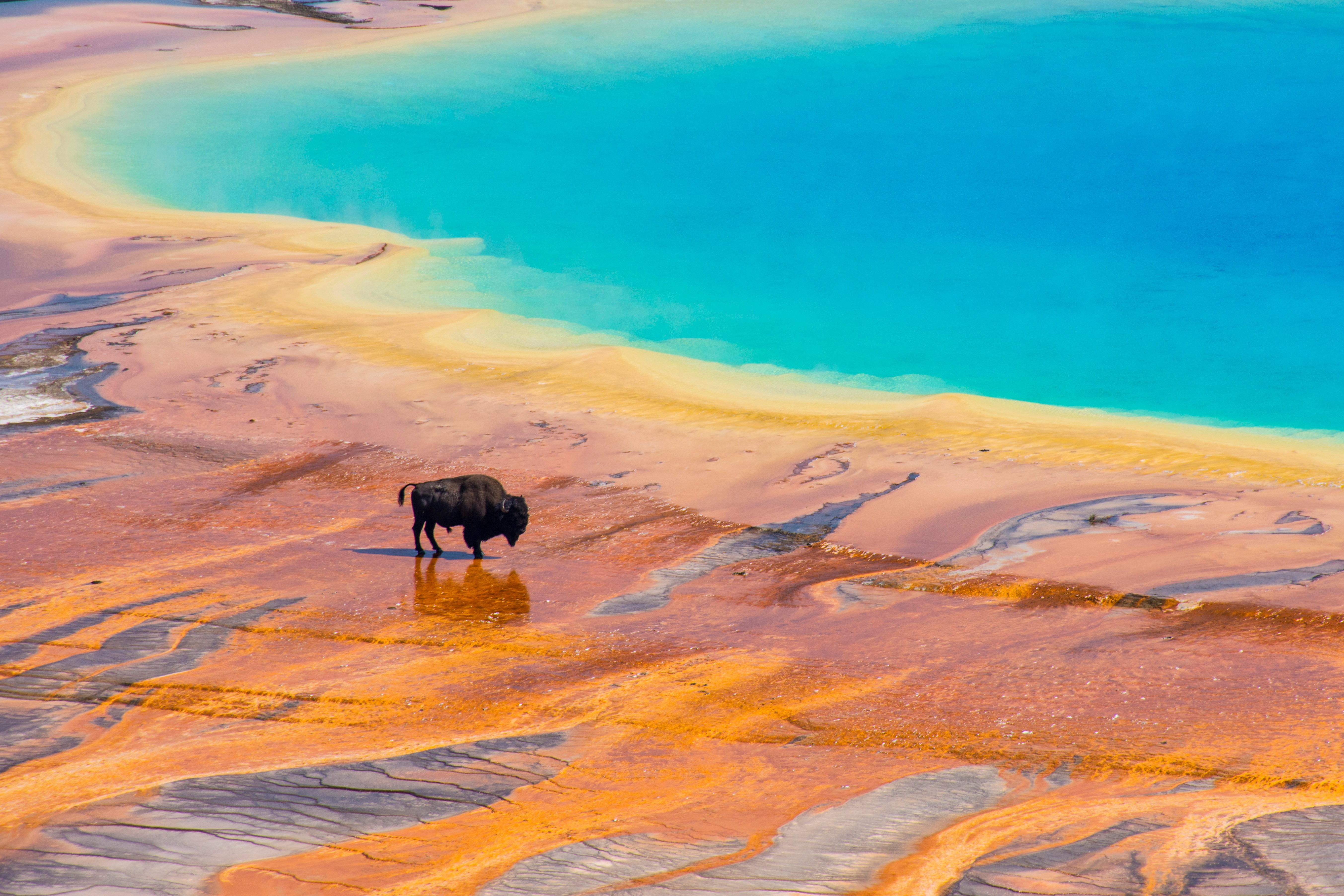
Midway Geyser Basin and Grand Prismatic Spring (Lower Loop) The drive's other showpiece destination: Grand Prismatic Spring, the largest hot spring in the United States and third-largest in the world (370 feet across, 121 feet deep). The spring's deep blue center is ringed by bands of green, yellow, orange, and red caused by thermophilic bacteria growing at progressively cooler water temperatures. The best ground-level view is from the boardwalk; the iconic aerial view is from the Grand Prismatic Overlook Trail (a 1.6-mile round-trip hike with significant elevation gain) on a hillside above the basin. Excelsior Geyser Crater at the basin's edge last erupted in 1985 but pours 4,000 gallons of boiling water per minute into the Firehole River.
Lower Geyser Basin and Firehole River The drive passes the Lower Geyser Basin, with the Fountain Paint Pot boardwalk (bubbling mud, geysers, and clay-rich springs) and Firehole Lake Drive (a 3-mile one-way loop featuring Great Fountain Geyser, White Dome Geyser, and Pink Cone Geyser). The Firehole Canyon Drive, a short two-way detour along the Firehole River, includes 40-foot Firehole Falls and Firehole Cascade.
Madison and the Madison River The junction of Norris-Madison and West Entrance roads, where the Firehole and Gibbon Rivers join to form the Madison River. Excellent fly-fishing for brown and rainbow trout. The Madison Information Station is a historic 1929 ranger station. Elk and bison frequently graze the meadows around Madison Junction.
Gibbon Falls An 84-foot waterfall on the Gibbon River, visible from a pullout off the road between Madison and Norris.
Norris Geyser Basin (intersection of Lower and Upper Loops) The hottest and most volatile geyser basin in the park, with two distinct areas linked by boardwalks:
- Porcelain Basin: A bone-white, otherworldly landscape of constant steam, where ground temperatures regularly exceed 200°F just below the crust
- Back Basin: A more forested area with Steamboat Geyser, the world's tallest active geyser, capable of eruptions over 380 feet (more than three times Old Faithful's height); Steamboat erupts on a wildly unpredictable schedule (years between major eruptions, then sometimes several in a year)
- Echinus Geyser, Cistern Spring, and dozens of smaller features
Obsidian Cliff (Upper Loop) A 100-foot black volcanic glass cliff between Norris and Mammoth, formed by rapid cooling of a lava flow 180,000 years ago. Native peoples quarried Obsidian Cliff for over 11,000 years; arrowheads and tools made from this obsidian have been found as far away as Ohio, evidence of vast prehistoric trade networks. The cliff is now protected and quarrying is prohibited.
Mount Washburn (Upper Loop, between Tower and Canyon) A 10,243-foot remnant volcanic cone with the park's premier panoramic viewpoint. The summit is accessed by a 3-mile (each way) trail from Dunraven Pass (with 1,400 feet of elevation gain). Bighorn sheep are commonly seen along the trail. A working fire lookout sits at the top.
Driving Tips
- The Grand Loop is best driven over at least 3 days, ideally 4 to 5, to allow time at the major thermal areas (Old Faithful, Mammoth, Norris, Midway), the Grand Canyon of the Yellowstone, Lamar Valley wildlife viewing, and Hayden Valley.
- Park entry fee is $35 per vehicle (7 days), $80 for the annual Yellowstone pass, or America the Beautiful Pass.
- Most park roads are closed November through late April or early May. Only the road from Gardiner (North Entrance) through Mammoth Hot Springs to Cooke City (Northeast Entrance) stays open year-round. Other entrances (West Yellowstone, South Entrance, East Entrance) and the inner Grand Loop sections open between mid-April (Mammoth-Old Faithful first) and late May (Beartooth Pass, Dunraven Pass last).
- Verify Northeast Entrance Road status. The 2022 floods severely damaged the road through Lamar Valley to Cooke City; reconstruction continued through 2023–2024. Confirm current accessibility before planning a Lamar Valley itinerary.
- Wildlife jams are a routine feature of Yellowstone driving. Maintain patience, do not honk, and never get out of your vehicle to approach wildlife. The federal regulation requires staying 100 yards from bears and wolves, 25 yards from all other wildlife (bison, elk, moose, deer, bighorn sheep). Multiple visitors are gored or trampled by bison each year, almost always after approaching too closely.
- Carry bear spray if hiking any trail. Available for purchase or rental at park stores in major villages.
- Stay on boardwalks in all geothermal areas. The ground crust is thin in many places, and the water below it can exceed 200°F. People have been killed and severely burned by falling through.
- The NPS Yellowstone App (free) provides real-time geyser predictions, ranger program schedules, and offline maps. Download before entering the park.
- Cell coverage is reliable only in the major villages (Mammoth, Old Faithful, Canyon, Lake, Grant). Most of the Grand Loop has no service.
- Reserve lodging well in advance. Yellowstone National Park Lodges (Xanterra) operates the in-park hotels (Old Faithful Inn, Lake Hotel, Mammoth Hotel, Canyon Lodge, Grant Village, and others); reservations open 13 months in advance and major lodges sell out in days. Gateway towns offer alternative accommodations: West Yellowstone (Montana), Gardiner (Montana), Cody (Wyoming), and Jackson (Wyoming, via Grand Teton).
- The best wildlife viewing is at dawn (before 7 a.m.) and dusk (after 7 p.m.) in Lamar Valley and Hayden Valley. Bring binoculars or a spotting scope; many visitors hire dedicated wildlife guides for early-morning wolf-watching trips.
- Old Faithful eruption times are posted at the visitor center and the major lodges. Arrive 15 to 20 minutes before predicted eruption time for a seat on the wooden benches.
- Fuel up in the major villages (Mammoth, Old Faithful, Canyon, Grant). Long stretches between villages have no fuel.
- Pair with Grand Teton National Park to the south (the John D. Rockefeller Jr. Memorial Parkway connects them) for a longer trip; together they form one of the world's premier wilderness destinations.
- For more information visit: Yellowstone National Park (NPS)