Tramuntana Mountain Road
The Island's Stone Spine
The Serra de Tramuntana runs the full length of Mallorca's northwest coast: a wall of limestone peaks, terraced olive groves, and sheer sea cliffs inscribed as a UNESCO Cultural Landscape in 2011. The MA-10 traces its spine from Andratx in the southwest to Pollença in the northeast, threading through stone villages built by Moors, adopted by monks, and made famous by Chopin, Robert Graves, and an Austrian archduke who spent forty-one years documenting every detail of the island. The road climbs through hairpin bends cut into mountainsides, drops to hidden coves with turquoise water, and passes thousands of kilometers of dry-stone terraces (the marjades) built without mortar over a millennium of cultivation. A side road to Sa Calobra delivers one of Europe's most celebrated mountain descents. At the far end, the Formentor Peninsula reaches into the Mediterranean like a pointed finger, its lighthouse perched on cliffs 210 meters above the sea.
Key Stops
Port d'Andratx The drive begins at the southwestern tip of the Tramuntana range. Port d'Andratx is a former fishing village turned upscale harbor, its waterfront lined with restaurants still supplied by working boats. Italian-style villas climb the surrounding hillsides, and the sheltered bay catches the last of the afternoon light. From here, the MA-10 begins its climb into the mountains.
Estellencs A tiny village of fewer than 400 residents clinging to the mountainside. The 17th-century parish church of Sant Joan Baptista and a 16th-century coastal defense tower mark the center. Nearby, the Mirador Ricardo Roca viewpoint offers the first of the drive's many vertiginous coastal panoramas. A steep two-kilometer walk descends to Cala Estellencs, a small rocky cove with turquoise water and ancient fishermen's boat shelters carved into the rock.
Banyalbufar The name comes from the Arabic for "vineyard by the sea," and the village earns it. Spectacular dry-stone terraces descend the mountainside from the road to the water's edge, originally built by the Moors in the 11th century. These terraces still cultivate the Malvasia grape, a variety virtually unique to this stretch of coast. The local wine was devastated by phylloxera in 1891 but revived in 1999 when virus-free clones were successfully propagated. Celler Ca'n Pico produces both dry and sweet Malvasia whites. The terraces, the wine, and the irrigation channels feeding them are a living example of the landscape that earned the UNESCO inscription.
Valldemossa One of the most visited villages in all of Spain, set at 400 meters amid olive and almond groves. The Real Cartuja (Royal Charterhouse), originally a palace built by King James II of Mallorca, became a Carthusian monastery in 1399 and functioned as one until 1835. In the winter of 1838 to 1839, Frédéric Chopin and George Sand rented Cell No. 4, where Chopin composed portions of his 24 Preludes, Op. 28, despite worsening tuberculosis and a winter far colder and wetter than they had expected. Sand's subsequent book Un Hiver à Majorque (1842) savaged local attitudes but rhapsodized the island's beauty, effectively inventing Mallorcan literary tourism. The Chopin and George Sand Museum within the monastery holds what the Chopin Institute in Warsaw considers the most important private collection dedicated to the composer in the world. Parking is extremely limited. Arrive before 10:00 AM in summer.
Son Marroig Between Valldemossa and Deià, this clifftop estate was purchased in 1870 by Archduke Ludwig Salvator of Austria, who made Mallorca his primary residence for forty-one years. A pioneering conservationist, he documented the islands' natural history, culture, and people in his monumental multi-volume work Die Balearen. The estate's white Carrara marble pavilion, perched on the cliff edge above the Na Foradada peninsula, frames one of the most photographed views in the Mediterranean. The house is now a museum with original furniture, maps, and photographs.
Deià A small stone village tumbling down a hillside to a rocky cove, long favored by artists and writers. The English poet and novelist Robert Graves moved here in 1929 and stayed, with interruptions, until his death in 1985. His house, Ca N'Alluny, where he wrote I, Claudius, Goodbye to All That, and The White Goddess, was restored and opened as a museum in 2006. The study, printing room, and garden are preserved as he left them. Open Monday through Friday; summer hours 9:30 AM to 4:30 PM. Graves is buried in the churchyard of Sant Joan Baptista on the hill above the village. Cala Deià, a small pebble cove below the village, is one of the island's most atmospheric swimming spots. Parking is very limited. Use the lots at the village edges.
Sóller A prosperous town set in a fertile valley of orange, lemon, and olive groves, historically isolated from Palma by the mountain barrier. The wealth from 19th-century citrus exports funded remarkable Modernista (Art Nouveau) architecture: the Banco de Sóller (1912), designed by a follower of Gaudí, features elaborate ironwork facades, while Can Prunera (1904 to 1911) is now a Modernista art museum. The Tranvía de Sóller, inaugurated in 1913, is one of only two surviving first-generation tramways in Spain. Its wooden carriages still rattle 4.8 kilometers through orange groves to Port de Sóller on the coast. The Ferrocarril de Sóller, a narrow-gauge railway from Palma, crosses mountain viaducts on wooden-benched trains dating from 1912. The Sóller road tunnel to Palma has been toll-free since 2017.
Fornalutx Nestled in the upper Sóller Valley at the foot of Puig Major (1,445 meters, Mallorca's highest peak), Fornalutx has been officially named Spain's most beautiful village, including the 1983 National Prize. With just 700 residents, the village is a tangle of narrow stone lanes, traditional houses with green-shuttered windows, and streets fragrant with citrus blossom. Surrounding terraces of orange and olive trees complete a scene that has barely changed in centuries.
Gorg Blau and Cúber Reservoirs Two reservoirs set in the high mountains between Sóller and Lluc, at the foot of Puig Major. The landscape here is stark: barren limestone peaks, low scrub, and still blue water reflecting the sky. Gorg Blau has supplied Palma's drinking water since 1971; Cúber sits higher, connected by a canal. Before Gorg Blau was flooded, archaeologists recovered remains of a prehistoric settlement. Puig Major's summit is closed to the public due to a military radar station established in 1959.
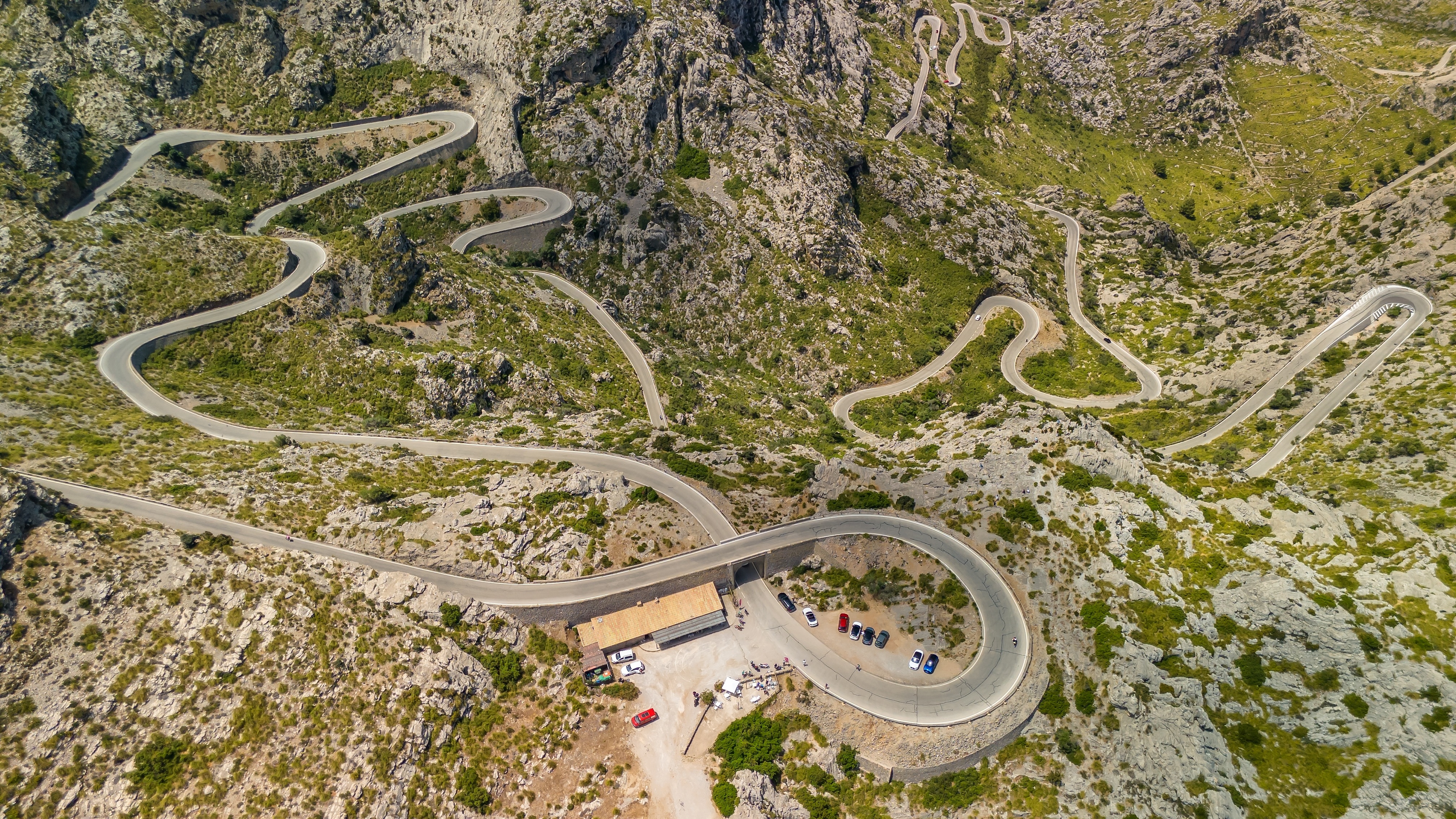
Sa Calobra and Torrent de Pareis (MA-2210) The side road to Sa Calobra is one of Europe's most famous mountain descents: 12.2 kilometers dropping 800 meters through 26 hairpin bends to sea level. At kilometer 9.5, the Nus de Sa Corbata (the Tie Knot) executes a 270-degree corkscrew loop, the road passing directly beneath its own upper section via a bridge. This was an engineering solution to avoid tunneling through the mountain. Allow 20 to 30 minutes to descend, longer behind tour buses. At the bottom, a walkway and two short tunnels carved through the cliff lead to the mouth of the Torrent de Pareis, a gorge nearly three kilometers long with vertical limestone walls up to 200 meters high and the second-largest canyon in the Mediterranean. Declared a Natural Monument in 2003. Every July, a classical concert is performed inside the gorge. The parking lot fills by mid-morning in summer; an alternative is arriving by boat from Port de Sóller.
Santuari de Lluc The spiritual heart of Mallorca, founded in the early 13th century after the 1229 Christian conquest. According to tradition, a shepherd boy discovered a stone image of the Virgin on the hillside; the figure miraculously returned to its original spot three times, and the sanctuary was built where it wanted to stay. The dark-skinned Madonna, known as La Moreneta, remains the island's patron and the object of major pilgrimages, including the annual Des Güell a Lluc a Peu, a moonlight walk in which approximately 10,000 people cover 50 kilometers from Palma to the monastery. The Escolania de Lluc, a boys' choir with a centuries-old tradition, sings at daily services. Accommodation is available at the monastery hospice.
Pollença A handsome inland town of honey-colored stone marking the northeastern end of the MA-10. The Calvari, 365 cypress-lined stone steps (one for each day of the year), climbs from near the Plaça Major to a Baroque chapel at the summit, with panoramic views over the town, the bay, and the mountains. On Good Friday, a torchlit procession reenacts the Stations of the Cross in solemn silence, figures in hooded robes descending the steps by candlelight. The main square hosts a popular Sunday market, and the town's summer music festival draws performers from across Europe.
Cap de Formentor The Formentor Peninsula extends approximately 20 kilometers northeast from Port de Pollença, a final, dramatic crescendo. The Mirador des Colomer, a vertiginous viewpoint above sheer cliffs, looks down on the rocky islet of El Colomer far below. Further along, Platja de Formentor offers a pine-backed sandy beach, and the road ends at the Cap de Formentor lighthouse, built in 1863 at 210 meters above the sea. Summer vehicle restrictions apply: from May 15 to October 15, private vehicles are prohibited between 10:00 AM and 10:00 PM. A shuttle bus (TIB line 334) runs every 35 minutes from Port de Pollença (EUR 1.80). To drive your own car, arrive before 10:00 AM or after 10:00 PM.
Driving Tips
- Rent small: A compact car navigates the narrow mountain sections and tight village streets far more easily than anything larger. Expect to encounter tour buses on the MA-10, particularly between Valldemossa and Sóller. One vehicle may need to reverse to a passing place.
- Sa Calobra timing: The parking lot at the bottom fills by mid-morning in peak season. Arrive early or take the boat from Port de Sóller instead. The road is equally spectacular in both directions. Do not rush the ascent.
- Cyclists: The Tramuntana roads are among Europe's premier cycling destinations, especially in spring. Thousands of riders train on the MA-10 and the Sa Calobra climb. Spanish law requires 1.5 meters of clearance when passing cyclists. Be patient on climbs and never overtake on blind curves.
- Cap de Formentor restrictions: From mid-May to mid-October (2026), private vehicles are banned between 10:00 AM and 10:00 PM. Use the shuttle bus from Port de Pollença, or drive very early morning or late evening.
- Speed limits: Recently reduced to 60 km/h (37 mph) on many MA-10 sections. Speed cameras are present.
- Fuel: Fill up in Andratx, Sóller, or Pollença. There are no fuel stations on the remote mountain stretches between these towns.
- No street lighting: Significant sections of the MA-10 have no lighting. Drive this route during daylight hours.
- Parking: Valldemossa and Deià are extremely congested in summer. Arrive before 10:00 AM. Blue-lined spaces are paid; white lines are free.
- Mountain goats: Watch for wild goats on the road, particularly in the higher sections near Gorg Blau.
- For more information visit: Mallorca Official Tourism, Serra de Tramuntana