The High Road to Taos & the Enchanted Circle
New Mexico's High Country: Adobe Villages and the Roof of the Sangre de Cristos
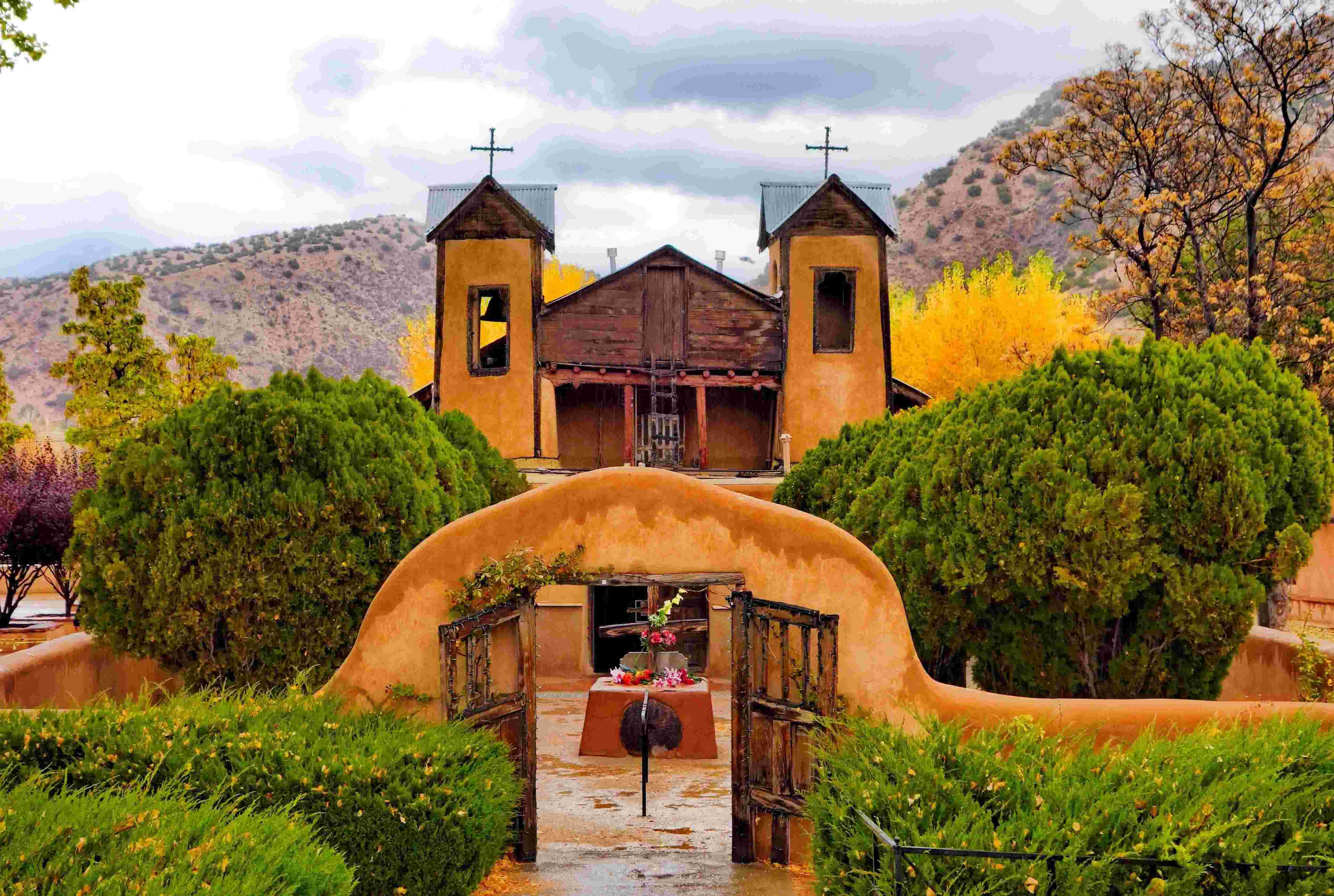
This combined tour links two of New Mexico's most celebrated scenic byways into a 139-mile arc through the Sangre de Cristo Mountains. The High Road to Taos climbs north from Santa Fe through 18th-century Hispanic mountain villages still inhabited by descendants of the original Spanish land-grant settlers, who maintain traditions of weaving, woodcarving (santeros carve devotional saints), and adobe church-building unchanged for three centuries. The road passes through Chimayó (home to the Santuario de Chimayó, the most-visited Catholic pilgrimage site in the United States, drawing 300,000 visitors a year), the artist village of Truchas (where Robert Redford filmed The Milagro Beanfield War), and Las Trampas, whose 1760 adobe church is the finest surviving Spanish colonial church in the country.
The road arrives at Taos, a 400-year crossroads of Spanish, Native American, and Anglo cultures. From there the Enchanted Circle loops 83 miles around 13,167-foot Wheeler Peak, New Mexico's highest mountain, passing the D.H. Lawrence Ranch (where the British author lived from 1922 to 1925), the dramatic Wild Rivers Recreation Area at the Rio Grande Gorge, the alpine ski village of Red River, Eagle Nest Lake at 8,300 feet, and the moving Vietnam Veterans Memorial near Angel Fire (the first major Vietnam memorial in the country, built in 1971). The tour passes Taos Pueblo, a UNESCO World Heritage Site continuously inhabited for over 1,000 years and the longest-occupied settlement in the United States.
Key Stops
Santa Fe The oldest state capital in the US (1610), at 7,199 feet. Use the Santa Fe Plaza, the Cathedral Basilica, and Canyon Road as your launchpad before heading north on US-84/285. About 17 miles north, take the exit for NM-503 toward Nambé and Chimayó to begin the High Road proper.
Nambé Pueblo and Nambé Falls A small side detour leads to Nambé Pueblo, one of the original Pueblo settlements predating Spanish arrival, with a recreation area that includes Nambé Falls (a three-tiered cascade) and Nambé Lake. Small entry fee charged by the pueblo.
Chimayó and El Santuario de Chimayó A small adobe chapel built between 1814 and 1816 on a site Native peoples revered for healing earth. The Santuario is the most important Catholic pilgrimage site in the United States, with a small back room (el pocito) containing a hole in the dirt floor from which pilgrims scoop "holy dirt" (tierra bendita) believed to have healing powers. Over 300,000 visitors come each year, and during Holy Week some 30,000 pilgrims walk to Chimayó from across northern New Mexico, some from as far as Albuquerque (90 miles). Free entry; donations welcomed. The village of Chimayó is also famous for the Ortega and Trujillo weaving families, who have produced traditional Río Grande textiles for nine generations; visit their working shops on the village plaza. Rancho de Chimayó restaurant (in a restored 1880s hacienda) serves the gold-standard of New Mexican cuisine.
Córdova A tiny village famous for its woodcarvers (santeros) whose unpainted, intricately detailed devotional carvings have been a regional art form since the early 19th century. Several family workshops welcome visitors. The descendants of master santero José Dolores López still carve in the village.
Truchas A village clinging to a ridge at 8,200 feet with panoramic views of the Truchas Peaks (a cluster of 13,000-foot summits) and the Rio Grande Valley below. Founded in 1754 as a Spanish land grant, Truchas remains a working Hispanic mountain village with adobe homes pressed against the road. The town gained wider recognition as the filming location for Robert Redford's The Milagro Beanfield War (1988), based on John Nichols's novel. Several galleries and artist studios occupy historic adobes along the main road; ask before photographing private homes or residents.
Las Trampas and the San José de Gracia Church The 1760 Iglesia de San José de Gracia is the finest surviving Spanish colonial church in the United States, with massive adobe walls, hand-hewn vigas, original 18th-century retablos (carved wooden altar screens) by colonial-era santeros, and a calm interior unchanged in over 250 years. The church is a National Historic Landmark and remains an active parish. Open to visitors when the doors are unlocked (typically Saturday mornings or by arrangement with the village mayordomo); donations welcomed.
Picurís Pueblo One of the smallest of the 19 New Mexico pueblos, with about 300 enrolled members. Picurís has been inhabited since around 1250 CE. The pueblo welcomes visitors to a small museum, the ruins of an older pueblo, and the 1776 Mission San Lorenzo de Picurís. Check current visiting policies at the pueblo office; photography may require a permit. The pueblo's San Lorenzo Feast Day is celebrated August 10.
Peñasco A larger village at the junction with NM-518, with several restaurants (Sugar Nymphs Bistro is a long-time favorite), galleries, and the Peñasco Theater (a community arts venue in a historic theater building).
Sipapu Ski and Summer Resort (Side Trip) A short detour east on NM-518 leads to Sipapu, a small family-friendly ski area in the Carson National Forest with mountain biking trails in summer.
Taos The High Road descends from Talpa into the Taos Valley, joining NM-68 (the Low Road from Santa Fe) just south of Ranchos de Taos. Ranchos de Taos is home to the San Francisco de Asís Mission Church (built 1772–1816), whose massive adobe buttresses on the rear apse were famously painted by Georgia O'Keeffe and photographed by Ansel Adams and Paul Strand. Continue north on NM-68 to Taos Plaza.
The hinge between the two drives. Plan a half to full day here before starting the Enchanted Circle.
- Taos Plaza with its surrounding adobe shops, galleries, and restaurants
- Taos Pueblo (UNESCO World Heritage Site): The multistory adobe dwellings of Taos Pueblo have been continuously inhabited for over 1,000 years, making it one of the longest-inhabited communities in North America. Entry fee approximately $25 per adult; the pueblo closes for ceremonial events without advance notice (call ahead to confirm). Photography requires a permit (additional fee); some areas are off-limits to photography.
- Millicent Rogers Museum (one of the finest Native American art collections in the Southwest)
- Harwood Museum and Taos Art Museum at Fechin House
- Kit Carson Home and Museum
- Mabel Dodge Luhan House (where D.H. Lawrence, Georgia O'Keeffe, Willa Cather, and Ansel Adams all stayed)
Arroyo Hondo and D.H. Lawrence Ranch North of Taos on NM-522, a small road leads to the D.H. Lawrence Ranch at the base of Lobo Peak, donated to the University of New Mexico in 1955 by Lawrence's widow Frieda. Lawrence lived here from 1922 to 1925, writing The Plumed Serpent and St. Mawr. His ashes are interred in a small memorial chapel on the property. The ranch is open to visitors free of charge but with limited hours; check the UNM website before visiting.
Wild Rivers Recreation Area A detour west from Questa leads to one of the most spectacular and least-visited gorges in New Mexico: the confluence of the Rio Grande and Red River in a deep volcanic basalt canyon 800 feet below the surrounding mesa. Several overlooks accessed by short trails; longer trails descend to the river. Part of the Río Grande del Norte National Monument (designated 2013). Free entry.
Questa A small community at the northern point of the Enchanted Circle, with the historic St. Anthony Church and the nearby Cabresto Lake. The Molycorp Mine (closed in 2014) once dominated the local economy.
Red River A small alpine ski village and summer resort at 8,750 feet, with a distinct Western-themed Main Street. Originally a gold and silver mining boomtown in the 1890s, Red River reinvented itself as a tourist destination and ski area in the 1950s. Particularly popular with Texan visitors. Bull o' the Woods Saloon, the Bull Pen, and the Texas Reds Steakhouse anchor a small but lively downtown.
Eagle Nest Lake State Park At 8,300 feet, this 2,400-acre alpine lake offers fishing, boating, and panoramic views of the Moreno Valley with Wheeler Peak rising to the west. The town of Eagle Nest sits at the south end with gas, food, and a few motels.
Vietnam Veterans Memorial State Park A profoundly moving memorial built in 1971 by Victor and Jeanne Westphall as a private tribute to their son Marine Lt. David Westphall, killed in Vietnam in 1968. The dramatic white sweeping curves of the chapel rise against the Moreno Valley; an adjacent visitor center museum tells the story of the Vietnam War and the memorial's history. This was the first major Vietnam veterans memorial built anywhere in the United States, predating the Washington memorial by 11 years. Now operated by the State of New Mexico. Free entry. Open daily.
Angel Fire Resort A four-season resort village with skiing in winter and golf, mountain biking, and zip-lining in summer. Angel Fire was developed in the 1960s by the Le Bus family. The base village at 8,400 feet anchors the town.
Palo Flechado Pass The Enchanted Circle climbs from Angel Fire over Palo Flechado Pass at 9,107 feet, with views of the Sangre de Cristos. Old Spanish trade routes crossed this pass to reach the buffalo plains east of the mountains.
Taos Canyon Return US-64 descends from Palo Flechado Pass through Taos Canyon, following the Rio Fernando past several small lodges, art studios, and the historic Shady Brook Resort, completing the Enchanted Circle back at Taos Plaza.
Driving Tips
- The High Road and Enchanted Circle work best as a multi-day touring loop. Plan to overnight in Taos at minimum; ideally also in Chimayó, Truchas, or Red River.
- Plan the High Road for a morning or early afternoon (the small Hispanic villages and the Santuario de Chimayó are best visited before the heat of the day, and shops close in late afternoon). Plan the Enchanted Circle for a longer day, leaving Taos by 9 a.m.
- Both drives are fully paved, two-lane mountain roads. The High Road has tight curves and narrow shoulders; the Enchanted Circle crosses high mountain passes (Bobcat Pass at 9,820 ft and Palo Flechado Pass at 9,107 ft) that can be snow-affected November through April.
- Winter conditions: Both routes remain open year-round but require winter tires and traction devices from November through March. Check New Mexico Department of Transportation conditions at nmroads.com.
- Photography of people, homes, religious processions, and pueblo ceremonies is restricted in many of the Hispanic villages and at all pueblos. Always ask permission. At Taos Pueblo and Picurís Pueblo, photo permits are required (Taos Pueblo: approximately $20 per camera).
- The Santuario de Chimayó is most crowded during Holy Week (the week before Easter), when the walking pilgrimage takes place. If visiting at other times, you'll typically have the chapel largely to yourself.
- Pueblos close to outside visitors during ceremonial events. These dates are often not publicized in advance. Call the pueblo office before visiting to confirm current accessibility.
- Altitude affects most visitors. Most of both drives sits between 7,000 and 10,000 feet. Drink water, limit alcohol initially, and acclimate before strenuous hiking.
- Aspen color in the Sangre de Cristos peaks in late September. The Enchanted Circle in particular is one of New Mexico's premier aspen drives.
- Many High Road villages have limited services. Fuel up in Santa Fe or Española before starting, in Taos before the Enchanted Circle, and in Red River, Eagle Nest, or Angel Fire on the loop.
- Cell coverage is reliable in Santa Fe, Taos, and Red River, intermittent in the High Road villages, and spotty over the Enchanted Circle's higher passes. Download offline maps.
- The 1772 San Francisco de Asís Mission Church at Ranchos de Taos and the 1760 San José de Gracia at Las Trampas are working parishes. Visit respectfully and avoid disturbing services. Both close for weddings and funerals without warning.
- For more information visit: High Road To Taos | Scenic Byway & Santuario de Chimayo