Scenic Byway 12
Where Stone Tells the Story of Time
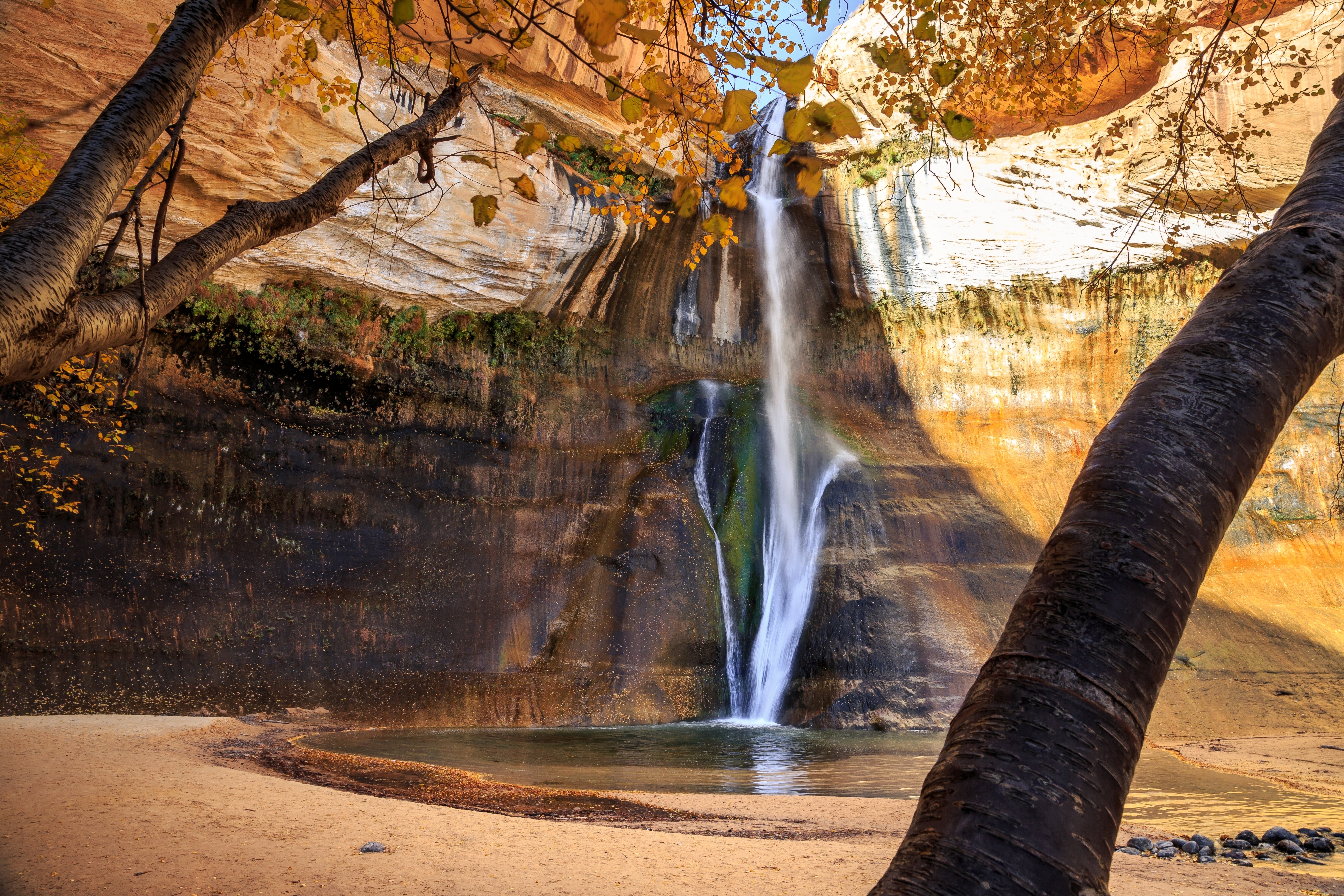
Utah's Scenic Byway 12 traces a 124-mile corridor through two billion years of exposed geology, linking Bryce Canyon to Capitol Reef across some of the most dramatically sculpted terrain on the planet. Designated an All-American Road — the only one in Utah — the route earns its subtitle, "A Journey Through Time," by passing through landscapes that shift from crimson slot canyons to alpine forests within a single hour of driving. From the vermilion tunnels of Red Canyon, the road climbs to Bryce Canyon's hoodoo amphitheatres, then drops through the painted desert of Grand Staircase–Escalante National Monument, where a six-mile hike leads to the 126-foot Lower Calf Creek Falls hidden in a sandstone alcove. The most exhilarating stretch is the Hogsback — a knife-edge ridge with sheer drop-offs on both sides and no guardrails — before the road reaches tiny Boulder, one of the last towns in America to receive its mail by mule train. From there, the byway climbs to nearly 9,600 feet across Boulder Mountain's forested plateau, with views stretching from Capitol Reef's Waterpocket Fold to the Henry Mountains and distant Navajo Mountain. It is, mile for mile, one of the most visually diverse drives in North America.
Key Stops
Red Canyon The byway announces itself in style, boring through terra-cotta rock tunnels as it enters this seven-mile canyon of scarlet and pink Claron Formation spires — the same geology as Bryce, but with a fraction of the crowds. The U.S. Forest Service visitor centre at the canyon's western end offers trail maps and interpretive displays. The Bird's Eye Trail (1 mile) climbs for an overview of the canyon floor, while the 8.6-mile paved Red Canyon Bicycle Trail winds through ponderosa forest and is used for cross-country skiing in winter. Outlaw hideouts once dotted the canyon's maze of nooks and crannies.
Bryce Canyon National Park Not actually a canyon at all, but a series of vast horseshoe-shaped amphitheatres carved along 18 miles of the Paunsaugunt Plateau's eastern edge. Thousands of hoodoos — fantastical stone spires sculpted by frost wedging — fill the amphitheatres in shades of orange, crimson, and gold that shift with the sun's angle. The Queen's Garden Trail from Sunrise Point descends among hoodoos named for Queen Victoria, while the Navajo Loop drops through narrow Wall Street. Drive the 18-mile scenic road south to Rainbow Point (9,115 feet) for bristlecone pines over a thousand years old. A free shuttle runs mid-April to mid-October (every 10–15 minutes). Entry is $35 per vehicle; the park is cashless at fee stations.
Kodachrome Basin State Park Seven miles south of Cannonville, a paved spur leads to this aptly named park — christened by the National Geographic Society — where 67 rust-coloured sandstone spires rise like frozen geysers, some reaching 17 storeys high. Hiking trails range from the quick Nature Trail to the steeper Eagle's View. Day use is $10 per vehicle. The park connects via dirt road to Grosvenor Arch, a massive double span deeper into Grand Staircase–Escalante National Monument.
Escalante Petrified Forest State Park Just west of Escalante, this 1,400-acre park displays over five million tons of fossilized wood — ancient logs transformed into stone painted in iridescent hues. An interpretive trail winds past the specimens, and the visitor Center houses 11th-century Indian artefacts and Jurassic dinosaur bones. Wide Hollow Reservoir offers swimming and canoeing in a cottonwood-ringed desert setting.
Grand Staircase–Escalante National Monument At nearly 1.87 million acres, this is the largest national monument in the American West — a vast wilderness of slot canyons, petrified forests, and paleontological sites spanning 200 million years. The Escalante Interagency Visitor Center in Escalante town is the best stop for maps, permits, and current trail conditions. Side trips include the Hole-in-the-Rock Road (57-mile dirt track to the cliffs where Mormon pioneers lowered wagons in 1880) and Hell's Backbone Road, which crosses a hair-raising bridge with views plunging into Box-Death Hollow Wilderness.
Calf Creek Falls Fifteen miles east of Escalante, the six-mile round-trip trail to Lower Calf Creek Falls is the byway's signature hike. The path passes prehistoric rock art and granary ruins before reaching the payoff: a 126-foot waterfall cascading into a turquoise pool within a shady sandstone amphitheatre. The trailhead was recently upgraded with new shade shelters, restrooms, expanded parking, and a relocated trail entrance. Day use is $5 per vehicle. Note: toxic cyanobacteria have been reported in the creek — do not drink the water or let pets wade in.
The Hogsback Between Escalante and Boulder, the road traverses one of the most thrilling stretches of highway in America — a razor-thin ridge with precipitous drop-offs plummeting hundreds of feet on both sides and no guardrails. There is nowhere to pull over and no room for error. The views are spectacular and the driving demands full concentration. Take it slow, keep your eyes on the road, and save the gawking for the pullouts on either end.
Boulder This tiny ranching community — the last town in the continental United States to receive mail by mule train (until 1940) — punches far above its weight in dining. Hell's Backbone Grill & Farm, named Salt Lake Magazine's Best Restaurant of 2026, serves Four Corners farm-to-table cuisine from its own on-site farm. The restaurant recently acquired the adjacent Boulder Mountain Lodge, creating a unified culinary and lodging destination. Anasazi State Park Museum preserves an Ancestral Puebloan village occupied from A.D. 1050 to 1200, with excavated artefacts and a life-sized six-room dwelling replica (open year-round, $20 family admission).
Boulder Mountain The byway's final act is its most elevated. Climbing to 9,600 feet through Dixie National Forest, the road crosses a cool, forested plateau of silvery aspens, Engelmann spruce, and hundreds of alpine lakes. Homestead Overlook (9,400 feet) provides a staggering 360-degree panorama — the Kaiparowits Plateau, Capitol Reef's Waterpocket Fold, the Henry Mountains, and on clear days, Navajo Mountain and the distant outline of Glen Canyon. This is the highest timbered plateau in North America and a world away from the desert you drove through an hour earlier. The descent toward Torrey unfurls Capitol Reef's red cliffs ahead.
Torrey & Capitol Reef National Park The byway ends at its junction with UT-24, minutes from Capitol Reef — one of Utah's least-visited national parks and all the more rewarding for it. The 100-mile Waterpocket Fold, a wrinkle in the Earth's crust, is the park's centrepiece. Pick fruit from the historic Fruita orchards, drive the scenic Capitol Reef road, or hike to Hickman Bridge. Entry is $20 per vehicle.
Driving Tips
- The Hogsback: No guardrails, no shoulders, steep drop-offs. Keep speed low, stay centred in your lane, and do not attempt to stop or reverse on the ridge. Not recommended in high winds, ice, or snow.
- Fuel: Fill up at every opportunity. Stations exist in Panguitch, Bryce Canyon City, Escalante, Boulder, and Torrey, but distances between them are significant and hours can be irregular, especially off-season.
- Elevation changes: The route spans 4,500 to 9,600 feet. Boulder Mountain can see snow from October through April — check UDOT road conditions at udottraffic.utah.gov before travelling in winter.
- Cell service: Limited to nonexistent between towns. Download offline maps and carry emergency supplies. AT&T has the best intermittent coverage; Boulder Mountain and the monument are dead zones for all carriers.
- EV charging: Very limited — Level 2 chargers in Escalante, Boulder, and Torrey only. No DC fast chargers along the route. Plan range carefully.
- Time: Allow a full day minimum; two days is ideal to hike Calf Creek Falls and explore Bryce Canyon without rushing. Lodging fills quickly in spring and autumn — book ahead.
- Photography: Early morning at Bryce Canyon (Sunrise Point lives up to its name), sunrise at Mormon Row–era barns near Kodachrome, and late afternoon light on Boulder Mountain are the prime windows.
- For more information visit: Visit Utah — Scenic Byway 12