San Juan Skyway
The Greatest Mountain Loop in the American West
The San Juan Skyway is the finest mountain loop drive in the United States: 233 miles through the rugged San Juan Mountains of southwestern Colorado, connecting four historic Victorian mining towns with the cliff dwellings of Mesa Verde National Park in a single circuit that crosses three high mountain passes and passes more than 100 named peaks over 13,000 feet. The route is anchored at its southern end by Durango, an 1880s railroad hub where the Durango & Silverton Narrow Gauge Railroad has been steaming up the Animas River canyon since 1882. From Durango, US-550 climbs north as the legendary Million Dollar Highway, a road blasted into cliff faces and threaded around precipices without guardrails over Coal Bank, Molas, and Red Mountain Passes, ending in Ouray, "the Switzerland of America," where waterfalls plunge from invisible heights and natural hot springs steam in a box canyon ringed by 13,000-foot peaks. The route then crosses Dallas Divide to Telluride, hidden at the head of a glacier-carved box canyon with its 365-foot Bridal Veil Falls (the longest free-falling waterfall in Colorado) and a free gondola connecting town with Mountain Village. The southern leg climbs over Lizard Head Pass, descends the Dolores River valley, and reaches Mesa Verde, where the ancestral Puebloan peoples built more than 600 cliff dwellings (some with hundreds of rooms) into sandstone alcoves between roughly 1190 and 1300 CE before mysteriously abandoning the mesa. The San Juans themselves were shaped by 30 million years of volcanic eruptions followed by 2 million years of glaciation, leaving a landscape of staircased ridges, hanging valleys, and turquoise alpine lakes. In late September, when the aspens turn brilliant gold against the dark spruce-fir forest, the loop ranks among the finest fall foliage drives in North America.
Key Stops
Durango The skyway's southern hub and largest town, founded in 1880 by the Denver & Rio Grande Railroad. The restored historic downtown (Main Avenue) preserves gas-lit streetlamps and Victorian storefronts now occupied by restaurants, breweries, galleries, and outdoor outfitters. Full services and the most lodging options on the loop. The Durango & Silverton Narrow Gauge Railroad (operating since 1882) runs daily summer round trips up the Animas River canyon to Silverton, with the route partially blasted into a cliff wall 400 feet above the river. The round-trip is approximately 9 hours; the train uses authentic coal-fired steam locomotives. Tickets approximately $109–$229 per adult depending on car class; reservations essential, often months ahead.
Animas River Valley and Purgatory Resort US-550 (the Skyway) departs Durango and parallels the Animas River north, passing cattle pastures and red-rock cliffs. The road climbs into the alpine zone around Purgatory Resort (formerly Durango Mountain Resort), a family-friendly ski area whose summer activities include scenic chairlift rides, a mountain coaster, and lift-served mountain biking.
Coal Bank Pass, Molas Pass, and Molas Lake The Skyway zigzags over Coal Bank Pass (10,640 ft) and Molas Pass (10,910 ft), with sweeping views across the Animas River canyon to the West Needle Mountains and the Grenadier Range. Molas Lake glints turquoise below; the Molas Pass overlook is one of the most photographed pullouts on the entire drive. The Continental Divide Trail and the Colorado Trail both cross the highway near Molas Pass.
Silverton The road drops sharply into Silverton, set on the floor of a glacial valley between 13,000-foot walls at 9,318 feet of elevation. Founded in 1874, Silverton was named (according to local lore) when a miner declared, "we may not have gold here, but we have silver by the ton." Greene Street (the main commercial avenue) and Blair Street (the former red-light district, where mock gunfights play out on summer evenings) preserve dozens of original Victorian-era buildings, including the gold-domed San Juan County Courthouse and the Grand Imperial Hotel. The San Juan County Historical Society Museum and the Mayflower Gold Mill (a fully restored mill on the National Register) tell the mining story. Hillside Cemetery above town holds the graves of miners killed in disasters. Silverton remains a tiny year-round town (population about 600) that swells with summer visitors arriving by train and highway.
Million Dollar Highway (Silverton to Ouray) The 25-mile stretch of US-550 between Silverton and Ouray is one of the most legendary drives in America: a two-lane road blasted into cliff faces, threaded through rock cuts, and routed around precipices without guardrails, climbing over Red Mountain Pass (11,018 ft, the loop's high point) and descending past the rust-colored slopes of Red Mountain and the ghostly headframes of the Idarado and other abandoned mines. The road is open year-round. Multiple stories explain the name: the cost per mile of construction, the value of low-grade gold tailings used as roadbed, the wealth of ore once hauled along it, or the views themselves. In winter, snowstorms can dump several feet of snow; CDOT crews fire howitzers at avalanche slopes to trigger controlled slides, then plow them away.
Ouray Tucked into a steep-walled box canyon at 7,792 feet, Ouray is known as the "Switzerland of America" for its precipitous mountain setting and Victorian architecture. The entire town is a National Historic District. Waterfalls plunge from the cliffs above, and natural sulfur-free hot springs feed the iconic Ouray Hot Springs Pool, the Wiesbaden, and the Twin Peaks lodges (the Ouray Hot Springs Pool holds over a million gallons; water temperatures range from 96 to 106°F). Box Canyon Falls, a short walk from town, thunders 285 feet through a 20-foot-wide slot in solid rock. In winter, the Ouray Ice Park (a free, world-class ice-climbing venue created by spraying water down the walls of a slot canyon) draws climbers from around the globe; the Ouray Ice Festival each January is a major event. The Bachelor-Syracuse Mine Tour, just north of town, takes visitors 1,800 feet horizontally into a working-replica gold and silver mine.
Ridgway The Skyway turns west on CO-62 at Ridgway, a former railroad town now best known as the filming location for the original True Grit (1969). Several Hollywood Westerns shot scenes here. Ridgway State Park sits on a turquoise reservoir below the imposing Mount Sneffels (14,158 ft).
Black Canyon of the Gunnison National Park (Side Trip) About an hour northeast via Montrose on US-50 and CO-347, the Black Canyon is one of the steepest, narrowest, and deepest gorges in North America: 48 miles long, plunging up to 2,722 feet, with parts of the canyon floor receiving only 33 minutes of sunlight per day. The South Rim Drive is the standard visitor experience. The Painted Wall at 2,250 feet is the tallest cliff in Colorado. Park entry $30 per vehicle.
Dallas Divide From Ridgway, CO-62 rolls west across ranchland and climbs to the Dallas Divide (8,970 ft), with one of Colorado's most iconic mountain views: the entire Sneffels Range, including 14,158-foot Mount Sneffels (named for a fictional volcano in Jules Verne's Journey to the Center of the Earth), rising abruptly above golden hay meadows. The view in late September, when the aspens peak, has appeared in countless photographs and paintings.
Last Dollar Road (Side Trip) A spur off CO-62 just east of Ridgway leads onto Last Dollar Road, a 21-mile unpaved scenic back road climbing through aspen groves with extraordinary views of the Sneffels Range. Requires a high-clearance vehicle in dry weather; impassable in winter. Some of the finest fall color in the state.
Telluride At Placerville, CO-145 turns south, then east at a spur up the San Miguel River into Telluride, hidden at the head of a glacial box canyon at 8,750 feet. The entire downtown is a National Historic District of Victorian-era brick and clapboard. Butch Cassidy robbed his first bank here in 1889 (the San Miguel Valley Bank, still standing on Colorado Avenue). The free Telluride Gondola connects the town with Mountain Village (Telluride Ski Resort's base) in a 13-minute ride with spectacular views, the only free public transit gondola in the United States, operating most of the year. Bridal Veil Falls, at the head of the valley, drops 365 feet (Colorado's longest free-falling waterfall) and can be reached by a two-hour round-trip hike. Telluride hosts a string of celebrated festivals: the Telluride Film Festival (Labor Day weekend), Bluegrass Festival (June), Jazz Festival, and many others. Full services and a major airport (Telluride Regional Airport at 9,070 feet is one of the highest commercial airports in North America).
Lizard Head Pass South of Telluride, CO-145 climbs over Lizard Head Pass (10,222 ft), named for the reptilian-shaped rock spire on the skyline. The pass crosses high meadows and aspen groves with Wilson Peak (14,023 ft, the mountain on the Coors beer label), Mount Wilson, and El Diente Peak (all 14ers) towering to the southwest. Trout Lake glints below, and a small campground with the optimistic name Matterhorn sits in the meadows.
Rico and the Dolores River Valley Beyond Lizard Head Pass, CO-145 descends along the Dolores River through Rico (Spanish for "rich"), a former mining boomtown whose Victorian buildings have been partially restored, and continues 30 miles through the meandering aspen-and-cottonwood-lined river valley to Dolores.
Dolores and the Anasazi Heritage Center A pleasant town above McPhee Reservoir, the site of ancient ancestral Puebloan settlements excavated before the reservoir flooded the valley. The Canyons of the Ancients Visitor Center and Museum (formerly the Anasazi Heritage Center), about four miles south of town, displays artifacts from the excavations along with a 25-room ruin and a full-scale pit house replica. Admission approximately $3–$5 per adult.
Cortez A strip town at the junction of CO-145 and US-160, with full services and lodging cheaper than Durango. Cortez sits in the Four Corners region; the Cortez Cultural Center features Native American art and summer dance performances.
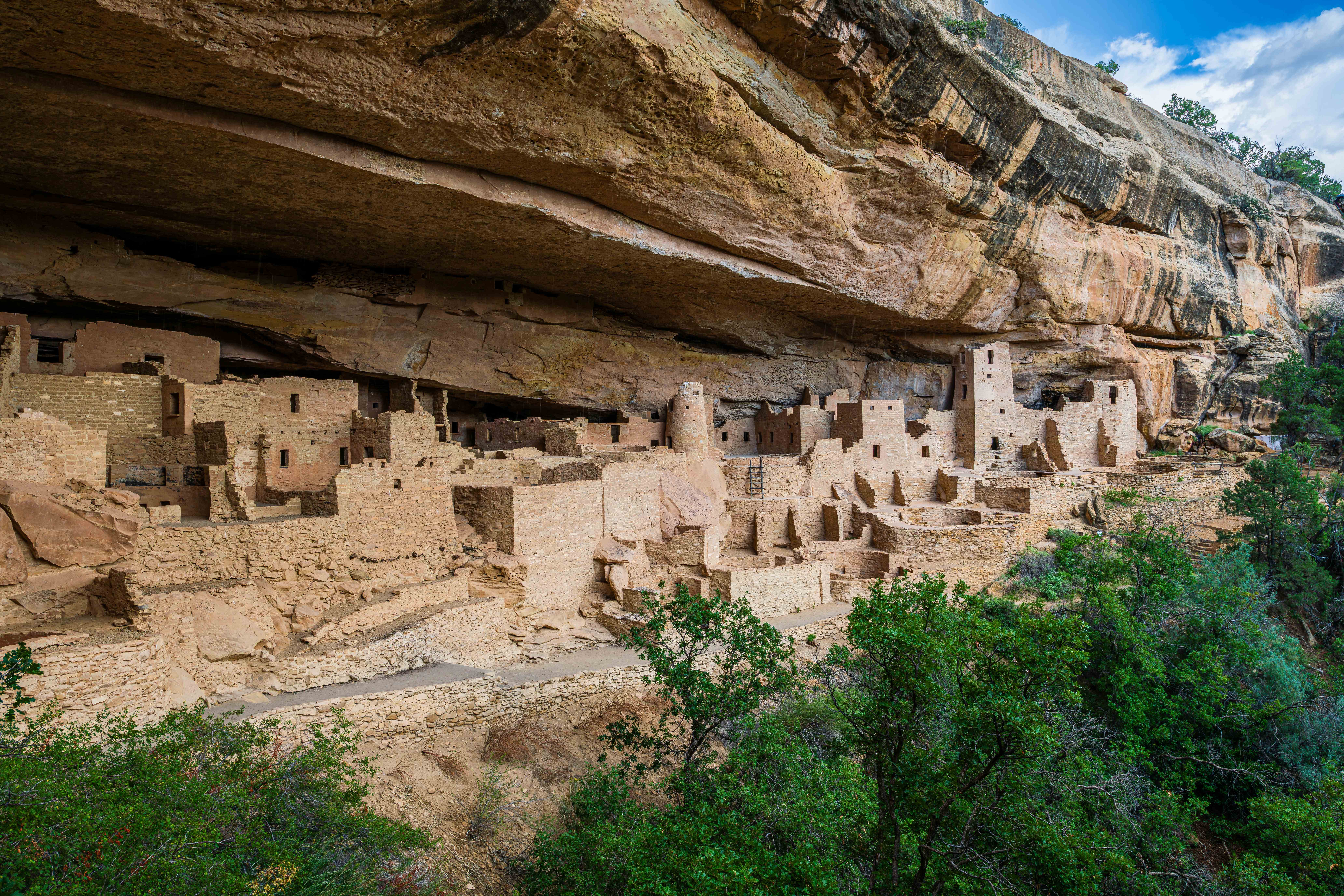
Mesa Verde National Park (UNESCO World Heritage Site) The Skyway's cultural climax: more than 600 cliff dwellings and over 5,000 archaeological sites preserving the legacy of the ancestral Puebloans who lived here from 550 to 1300 CE. The most spectacular sites (Cliff Palace, Balcony House, Long House) require ranger-guided tours with timed entry tickets booked through Recreation.gov, available 14 days in advance and selling out quickly in summer. Spruce Tree House (one of the largest dwellings, with 130 rooms) is self-guided when open. The Chapin Mesa Archeological Museum provides essential context. Mesa Top Loop and Wetherill Mesa offer additional cliff dwellings and overlooks accessible without tickets. Cliff Palace was discovered in 1888 by ranchers Richard Wetherill and Charlie Mason while searching for stray cattle in a snowstorm. The park sits on a high mesa with a one-way entrance road that climbs and curves for 21 miles to Chapin Mesa headquarters; allow at least one full day. Entry $30 per vehicle.
Mancos A small ranching town between Mesa Verde and Durango with Old West character, several restaurants, and Mancos State Park nearby. Novelist Louis L'Amour wrote many of his westerns inspired by this country.
Return to Durango US-160 continues east through aromatic sagebrush flats and ranchland back to Durango, completing the loop.
Driving Tips
- Drive the loop in either direction. Counterclockwise from Durango (north on US-550 over the Million Dollar Highway first) builds dramatic tension, with the historic mining towns and high passes early, the Telluride detour and Mesa Verde later. Clockwise saves the Million Dollar Highway for the climactic finale.
- Allow 2 to 3 days minimum. The drive can be done in a long day (6 hours), but doing so misses the point entirely. Recommended overnight stops are Ouray or Telluride (north side) and Cortez or Durango (south side).
- The Million Dollar Highway is open year-round but is a serious mountain road: narrow lanes, no guardrails along long stretches, steep drops, and tight curves. Drive slowly, use lower gears, and never stop in the road for photos. In winter, carry chains and a shovel; CDOT closes the road for avalanche control without notice. Check cotrip.org for current conditions.
- Book Mesa Verde guided tours (Cliff Palace, Balcony House, Long House) through Recreation.gov well in advance. Tickets become available 14 days ahead and routinely sell out within hours for summer dates.
- Book the Durango & Silverton Narrow Gauge Railroad months in advance for summer travel. The day trip to Silverton is 9 hours total; many travelers prefer to drive one way and take the train the other (one-way tickets and bus shuttles available).
- Telluride accommodations book up well in advance for festivals (especially Film Festival over Labor Day weekend and Bluegrass Festival in June). Mountain Village (accessible via the free gondola) often has better availability than Telluride itself.
- Late September (typically the third week) brings peak aspen color, particularly on Dallas Divide, Lizard Head Pass, Last Dollar Road, and the Million Dollar Highway. This is the most crowded time on the loop; book lodging months ahead.
- The America the Beautiful Pass ($80 annual) covers Mesa Verde and Black Canyon of the Gunnison and is excellent value if you also plan to visit other parks.
- Altitude affects most visitors. The loop crosses three passes above 10,000 feet, and Silverton, Telluride, and Ouray all sit above 7,000 feet. Drink extra water, limit alcohol the first day, and consider acclimating at Durango (6,512 ft) before high-altitude hikes.
- Summer afternoon thunderstorms are intense and can produce lightning at high passes and on exposed trails. Plan high-elevation hikes to be off summits by noon.
- Cell coverage is reliable in Durango, Telluride, and Ouray, spotty between towns, and nonexistent at high passes. Download offline maps.
- For more information visit: Colorado Scenic Byway: San Juan Skyway | Colorado.com