Saaremaa & Muhu Island Loop
Windmills, a Meteorite Crater, and the Baltic's Best-Preserved Castle
Saaremaa is Estonia's largest island, and together with its small neighbor Muhu it distills everything distinctive about the Baltic islands into one unhurried loop: wooden windmills on stony ridges, thatched fishing villages behind dry-stone walls, juniper heaths running down to a shallow silver sea, and a walk-in meteorite crater for good measure. The drive starts the moment you roll off the ferry at Kuivastu, crosses Muhu, then follows a causeway onto Saaremaa for a circuit of the north coast cliffs, the wild west around Vilsandi National Park, the long dagger of the Sõrve Peninsula, and the spa-town capital of Kuressaare with its moated medieval castle. Half a century as a closed Soviet border zone left the islands underdeveloped, which is exactly their charm today: traffic is thin, villages are quiet, and the old ways (windmill flour, home-brewed beer, handicraft sweaters) survived here better than almost anywhere on the Baltic.
Key Stops
The Virtsu to Kuivastu ferry. The trip starts on the water: a 30-minute crossing of the Suur Strait with gulls trailing the stern. Ferries run roughly hourly (more often in summer), and grabbing coffee on the deck as the mainland recedes is the correct way to begin island time.
Koguva, Muhu. One of the best-preserved traditional villages in Estonia: a knot of thatched farmhouses and lichen-covered stone walls on Muhu's western shore, now home to the Muhu Museum. Elsewhere on the island, the medieval church at Liiva and the manor at Pädaste (now a renowned country-house hotel and restaurant) justify a slow crossing of what most visitors treat as a drive-through.
Väinatamm causeway and the Orissaare oak. A 19th-century causeway carries the road from Muhu onto Saaremaa. Just beyond, the small town of Orissaare has one of Estonia's most photographed oddities: a solitary oak tree growing in the middle of the town stadium, voted European Tree of the Year in 2015 after generations of footballers simply played around it.
Angla Windmill Hill. Five wooden windmills lined along a ridge, the last surviving group of the hundreds that once turned across Saaremaa. Four are traditional post mills and one a taller Dutch-style mill; a heritage culture center alongside demonstrates milling and island crafts. The 14th-century Karja church, a short hop away, hides some of Estonia's finest medieval stone carvings.
Panga cliff. The north coast's limestone escarpment, rising about 21 meters straight from the sea, the highest cliff on Estonia's western islands. An ancient sacrificial site for islanders, it now serves gentler purposes: this is the loop's best sunset viewpoint.
Vilsandi National Park and Kihelkonna. Saaremaa's wild west: a scatter of islets, reefs, and juniper coastline protecting seal colonies and huge migrating bird flocks, founded on one of the oldest nature reserves in the Baltics. Boat and kayak trips leave from Papissaare harbor in season; the tall church at Kihelkonna doubled for centuries as a landmark for sailors. The Mihkli Farm Museum nearby preserves a complete 18th-century island farmstead.
Sõrve Peninsula. A 40 km spur south from Kuressaare down a narrowing tongue of land with the sea pressing in on both sides, ending at the striped Sõrve lighthouse, where Latvia is visible across the strait on clear days. The peninsula saw ferocious fighting in 1944, and bunkers, battery ruins, and a small military museum at Sääre tell the story. An out-and-back detour, and worth every kilometer.
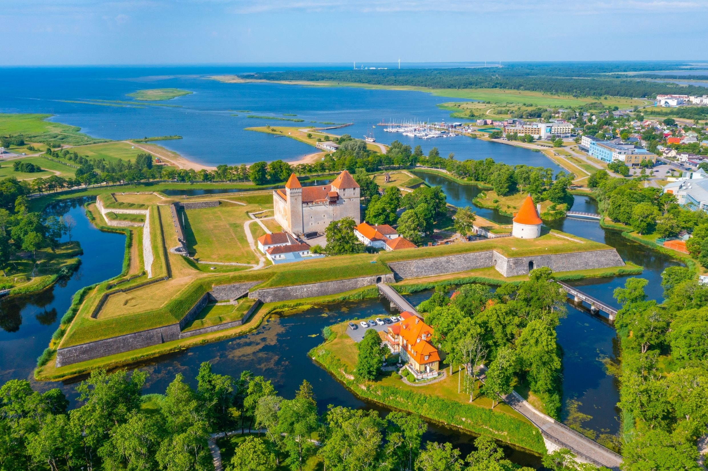
Kuressaare. The island capital and one of the most pleasant small towns in the Baltics. Its centerpiece is the 14th-century episcopal castle, widely considered the best-preserved medieval fortress in the Baltic states, ringed by a moat and park and housing the Saaremaa Museum. The town around it runs on spa hotels, good restaurants, and a summer opera festival staged in the castle grounds.
Kaali meteorite crater. A short detour off the road back east: a perfectly circular, tree-ringed crater lake 110 meters across and 22 meters deep, blasted out by a meteorite thousands of years ago (age estimates vary by millennia; the impact may have echoed through regional folklore). It is among the first impact craters in Europe proven as such, with a visitor center explaining the science.
Return across Muhu. Recross the causeway for the ferry home, ideally timed to leave room for a final Muhu stop: the island is famous for its bread, its embroidery, and its ostrich farm, an unexpectedly popular family detour near the main road.
Driving Tips
Book the ferry ahead in summer. Crossings are frequent and short, but cars without reservations queue on a first-come basis, and Friday evening sailings to the islands (and Sunday returns) fill up in July. Reserve online through the ferry operator and arrive 15 minutes early.
Expect gravel, and don't fear it. Main roads are paved, but many of the best sights (Koguva, parts of the west coast, Sõrve side roads) involve well-graded gravel. Any normal car copes fine; just slow down for dust, washboard sections, and loose stones.
Watch for wildlife at dawn and dusk. Roe deer are everywhere, and wild boar and elk cross island roads regularly. Most of the loop has a 90 km/h limit, but low light calls for much less.
Fuel up in Kuressaare or Orissaare. Stations are scarce on the Sõrve Peninsula and the wild west coast; start those legs with a comfortable tank.
Give Sõrve half a day. It looks like a quick detour on the map but is 80 km round trip on slow roads, and the lighthouse, bunkers, and coastal views deserve unhurried time.
Book ahead for late July. Kuressaare's opera festival and Estonia's general summer-holiday peak fill the island's rooms. June and late August offer the same weather with breathing room.
Keep to tracks on the heaths. Saaremaa's juniper heaths and thin-soiled alvar grasslands are protected habitats that scar easily. Park in marked spots and walk from there.
Consider the Hiiumaa extension. From Triigi on Saaremaa's north coast, a small ferry crosses a few times daily to Hiiumaa, Estonia's second island, turning the loop into a grand two-island tour.
Winter brings a rare novelty. In hard winters Estonia opens official ice roads across the frozen strait, among the longest in Europe. Magical, strictly condition-dependent, and governed by special rules (seatbelts off, set speeds, spacing between cars); check official status before dreaming of it.
For more information visit: Visit Estonia: Saaremaa Island