Red Rocks Country
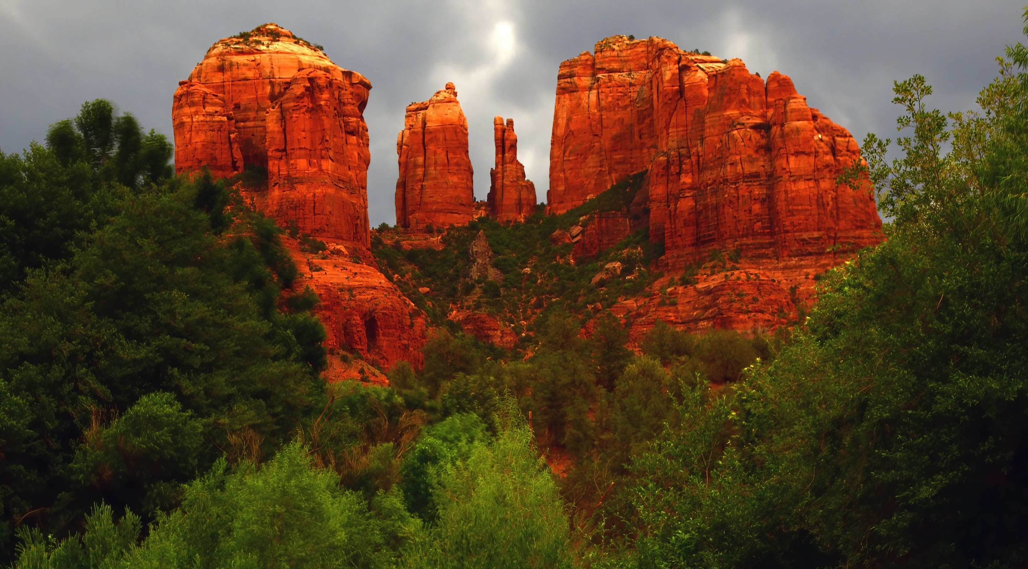
Arizona's Cathedral of Sandstone
Red Rock Country compresses the geological drama of the American Southwest into a 79-mile stretch of north-central Arizona, descending from Flagstaff's cool ponderosa forests at 7,000 feet through Oak Creek Canyon to the sandstone amphitheaters of Sedona, then climbing again through the old copper-mining town of Jerome and over Mingus Mountain to the territorial capital of Prescott. The road drops 2,600 feet in just 30 miles between Flagstaff and Sedona, switchbacking down mile-wide Oak Creek Canyon (a gorge so steep that Western novelist Zane Grey, who set Call of the Canyon here in 1924, described it as if "the very forest-fringed earth seemed to have opened into a deep abyss"). At Sedona, the road levels out among brilliantly banded buttes, mesas, and spires whose 2,000-foot walls of Schnebly Hill sandstone and Coconino limestone glow vermillion, salmon, and ochre in shifting daylight. The reds come from iron oxide deposited when this region lay beneath an inland sea hundreds of millions of years ago. Sedona is the heart of the Southwest's New Age movement, where "vortices" of psychic energy are said to swirl around landmarks like Cathedral Rock, Bell Rock, and Boynton Canyon (the metaphysical claim is debated; the photographic value is not). Beyond Sedona, the route enters the Verde Valley, where Tuzigoot and Montezuma Castle preserve the multi-story pueblos of the Sinagua people, who farmed these bottomlands until vanishing around 1425 CE for reasons that remain unknown. The road then climbs Cleopatra Hill to Jerome, the "wickedest town in America" at its 1900 peak, now a ghost-town-turned-artist-colony clinging to a 30-degree slope, before topping Mingus Mountain (7,023 ft) and descending to Prescott, where Whiskey Row preserves an authentic frontier square that once anchored the Arizona Territorial capital.
Key Stops
Oak Creek Vista Point A few miles south of Flagstaff, the first dramatic overlook into Oak Creek Canyon, with sheer rock faces of orange, red, pink, and chalky white plunging more than 1,000 feet to the canyon floor. A short paved trail leads to the viewing platforms. Native American vendors typically display jewelry and crafts at the overlook from spring through fall. Free, no pass required.
Oak Creek Canyon Switchbacks AZ-89A descends through a series of dizzying hairpin turns, dropping over 2,000 feet to the canyon floor. Each switchback opens a new perspective on the canyon. Pulloffs are limited; drive carefully and allow following traffic to pass.
West Fork Trail (Call of the Canyon Day Use Area) A mile south of Cave Springs Campground, the trail follows the West Fork of Oak Creek through a slot canyon between red walls hundreds of feet high. The classic 3-mile out-and-back ends where the canyon narrows and requires wading; the upper canyon involves serious technical canyoneering. One of the most photographed hikes in Arizona, particularly in early November when the maples turn brilliant gold and red. Parking fills early; arrive before 9 a.m. or use Sedona Shuttle when running. Day-use fee approximately $13 per vehicle (Coconino Pass site).
Slide Rock State Park A natural sandstone water chute on Oak Creek where smooth red bedrock has been polished into an 80-foot algae-slick water slide. The creek tumbles through the chute into a frigid pool, creating one of Arizona's most beloved swimming holes. Once a homestead apple orchard (still operating), now a state park. Fees vary by season: approximately $20 per vehicle weekdays, $30 weekends from March through May; $20 in winter months. Beginning May 1, 2026, lining up on Highway 89A is prohibited; once the lot fills, the entrance closes until significant spots open. Arrive early. No reservations available.
Sedona The drive's centerpiece, a town of 10,000 set in a natural amphitheater of red rock buttes named for Sedona Schnebly, who arrived with her husband in 1902. Sedona has flawless year-round weather, an active arts community (more than 80 galleries), excellent restaurants, and a downtown that mixes the genuine with the metaphysically themed. The most iconic formations include Bell Rock, Courthouse Butte, Cathedral Rock, Coffee Pot Rock, Capital Butte, and Snoopy Rock. The Tlaquepaque Arts and Shopping Village is a 4-acre Mexican-inspired plaza of galleries and fountains. The Chapel of the Holy Cross, finished in 1956, is a striking concrete wedge with a 90-foot cross set into a sandstone cliff south of town.
Pink Adventure Tours and Vortex Tours Sedona's iconic pink-painted open Jeeps (formerly Pink Jeep Tours) offer guided off-road tours into the back country and to the vortex sites. The Touch the Earth vortex tour runs about 2.5 hours and approximately $105 per adult; the Broken Arrow signature tour runs the company's flagship Jeep trail at approximately $99 per adult. Book in advance.
Schnebly Hill Road (Side Trip) A 6-mile scenic road climbing east from Sedona through Bear Wallow Canyon to Schnebly Hill Vista at 6,000 feet. Only the first mile is paved; the rest is rough graded dirt requiring high-clearance vehicles. The summit overlook takes in the Verde Valley, Sedona, and the mouth of Oak Creek Canyon. Some of the finest views in Red Rock Country.
Cathedral Rock Among Sedona's most photographed formations and recognized as one of the major "vortex" sites. The trail (1.2 miles round trip, 750 feet of elevation gain) climbs to the saddle between the spires for sweeping views. Important access change: The Cathedral Rock and Soldier Pass trailhead parking lots are closed Thursday through Sunday, 7 a.m. to 5:30 p.m., when the free Sedona Shuttle is operating. Use the North SR-179 Park and Ride. Monday through Wednesday, the trailheads remain open to private vehicles. The Sedona Shuttle expands to seven days a week for spring break and other peak holiday periods.
Sedona Shuttle (Free) A free, year-round shuttle bus serving Cathedral Rock, Little Horse, Soldier Pass, Dry Creek Vista, and Mescal trailheads from central Sedona park-and-rides. Thursday through Sunday, 7 a.m. to 5:30 p.m., with daily operation during peak periods. No reservations required.
Red Rock State Park Three miles south of Sedona via Lower Red Rock Loop Road, a 286-acre nature preserve along Oak Creek where more than 150 bird species have been documented. The visitor center offers exhibits on creek ecology, and several short loop trails (Smoke Trail, Eagle's Nest Trail) wander through the riparian corridor. Quieter than Slide Rock; better for birding than swimming. Approximately $7 per adult.
Dead Horse Ranch State Park On the Verde River near Cottonwood, named for the dead horse the original owners found on the property when they bought it in the 1950s. More than 300 acres of riverside camping, fishing lagoons stocked with trout and bass, and shaded hiking trails along the Verde.
Tuzigoot National Monument A 110-room Sinagua hilltop pueblo built between roughly 1000 and 1400 CE on a limestone ridge above the Verde River. At its peak around 1300, Tuzigoot housed approximately 250 people. The pueblo was built almost entirely without exterior doors; residents entered through rooftop hatches via ladders, suggesting defense against warring neighbors. A short paved loop trail accesses the ruins. Admission $10 per adult; the ticket also covers Montezuma Castle within 7 days.
Montezuma Castle National Monument (Side Trip) About 30 miles east of Tuzigoot near Camp Verde, a five-story Sinagua cliff dwelling tucked into a limestone alcove 80 feet above the valley floor. Built around 1100 to 1425 CE and remarkably well preserved. Named, incorrectly, by early Anglo settlers who thought it was built by Aztecs fleeing north. Self-guided trail along the base of the cliff. Same fee covers Tuzigoot.
Verde Canyon Railroad A 40-mile, 4-hour heritage train running between Clarkdale and the ghost town of Perkinsville along the upper Verde River, through canyon walls inaccessible by road. The train crosses trestles and a 680-foot tunnel, passing Sinagua ruins and prime bald eagle habitat (the canyon hosts a wintering flock). Coach class starts around $139 per adult; first class higher. Reservations essential, especially for special-event runs (Ales on Rails, Starlight, etc.).
Jerome A historic copper-mining town clinging to Cleopatra Hill at 5,200 feet, where some streets are so steep that residents joke their neighbors can look down their chimneys from the front porch. Founded 1882 around the United Verde Copper Mine, Jerome reached a population of 15,000 by 1929 and was dubbed "the wickedest town in America" for its concentration of saloons, gambling houses, and brothels. The mines closed in 1953, leaving a near-ghost town that has been revived as an artist colony with galleries, wine-tasting rooms (the Verde Valley AVA's wineries cluster here), and the Jerome Grand Hotel (a former hospital reputed to be one of America's most haunted). Jerome State Historic Park preserves the 8,700-square-foot Douglas Mansion (1916) with mining exhibits; open daily 8:30 a.m. to 4:45 p.m., $7 per adult.
Mingus Mountain Pass AZ-89A climbs to 7,023 feet at the summit of Mingus Mountain, with overlooks across the Verde Valley and back toward the San Francisco Peaks. The descent into Prescott Valley unfolds in long sweeping curves.
Prescott The drive's southern terminus and Arizona's original territorial capital (1864–1867 and 1877–1889). Set in the cool ponderosa pine forests of the Bradshaw Mountains at 5,400 feet, Prescott has retained an unhurried Western character. The central Courthouse Plaza is one of the finest small-town squares in the West. Whiskey Row on Montezuma Street still hosts the Palace Saloon (operating since 1877; Wyatt Earp and Doc Holliday drank here), the Hotel St. Michael, and several other historic establishments. Just north of town, the Granite Dells are a labyrinth of weathered granite boulders surrounding Watson Lake and Willow Lake (excellent for kayaking, hiking, and rock climbing). The Sharlot Hall Museum, the Phippen Museum of Western Art, and the Smoki Museum of American Indian Art complete a strong cultural lineup.
Driving Tips
- Drive north to south (Flagstaff to Prescott) for the most dramatic narrative: the descent down Oak Creek Canyon, the gradual reveal of Sedona's red walls, the climb to Jerome, and the cool finish in Prescott. The reverse direction works too, with the climb into Oak Creek Canyon as a strong finale.
- The Red Rock Pass is required at most Coconino National Forest trailheads in the Sedona area ($5 daily, $15 weekly, $20 annual). America the Beautiful passes are accepted at Forest Service sites but not at four concessionaire-managed sites: Crescent Moon (Red Rock Crossing), Grasshopper Point, Call of the Canyon (West Fork), and Banjo Bill. These require the separate Coconino Pass or a day fee.
- Cathedral Rock and Soldier Pass trailheads are closed to private vehicles Thursday through Sunday from 7 a.m. to 5:30 p.m. (and daily during peak holidays). Use the free Sedona Shuttle from the central park-and-rides. Monday through Wednesday, the trailheads remain open.
- Slide Rock State Park fills early, especially on summer weekends. Arrive before 9 a.m. or expect long waits. Beginning May 1, 2026, vehicles cannot queue on Highway 89A; the entrance closes when the lot is full and only reopens when significant capacity becomes available.
- Sedona traffic is notorious. The "Y" intersection (89A and 179) becomes severely congested between 10 a.m. and 4 p.m. Plan to be elsewhere during those hours, or use the shuttle.
- Schnebly Hill Road and other back-country routes require high-clearance vehicles. Rental car contracts typically prohibit travel on unpaved roads; check before driving.
- Summer monsoon afternoons (July through September) bring sudden, intense thunderstorms. Flash floods are a serious hazard in slot canyons (West Fork, Sycamore Canyon, Dry Creek). Check weather and never enter narrow canyons if storms are forecast anywhere in the drainage.
- Coconino National Forest and the Sedona Fire District typically enter Stage 1 or Stage 2 fire restrictions from late spring through monsoon onset. No campfires outside designated rings; restrictions on smoking, off-road driving, and other ignition sources. Check current status before camping or hiking.
- Fall foliage in Oak Creek Canyon peaks in early November (later than other Western canyons due to its elevation).
- Lodging in Sedona is expensive and fills well in advance, especially March through May and September through November. Flagstaff, Cottonwood, and Jerome offer more affordable alternatives within easy driving distance.
- For more information visit: Visit Sedona