Monument Valley
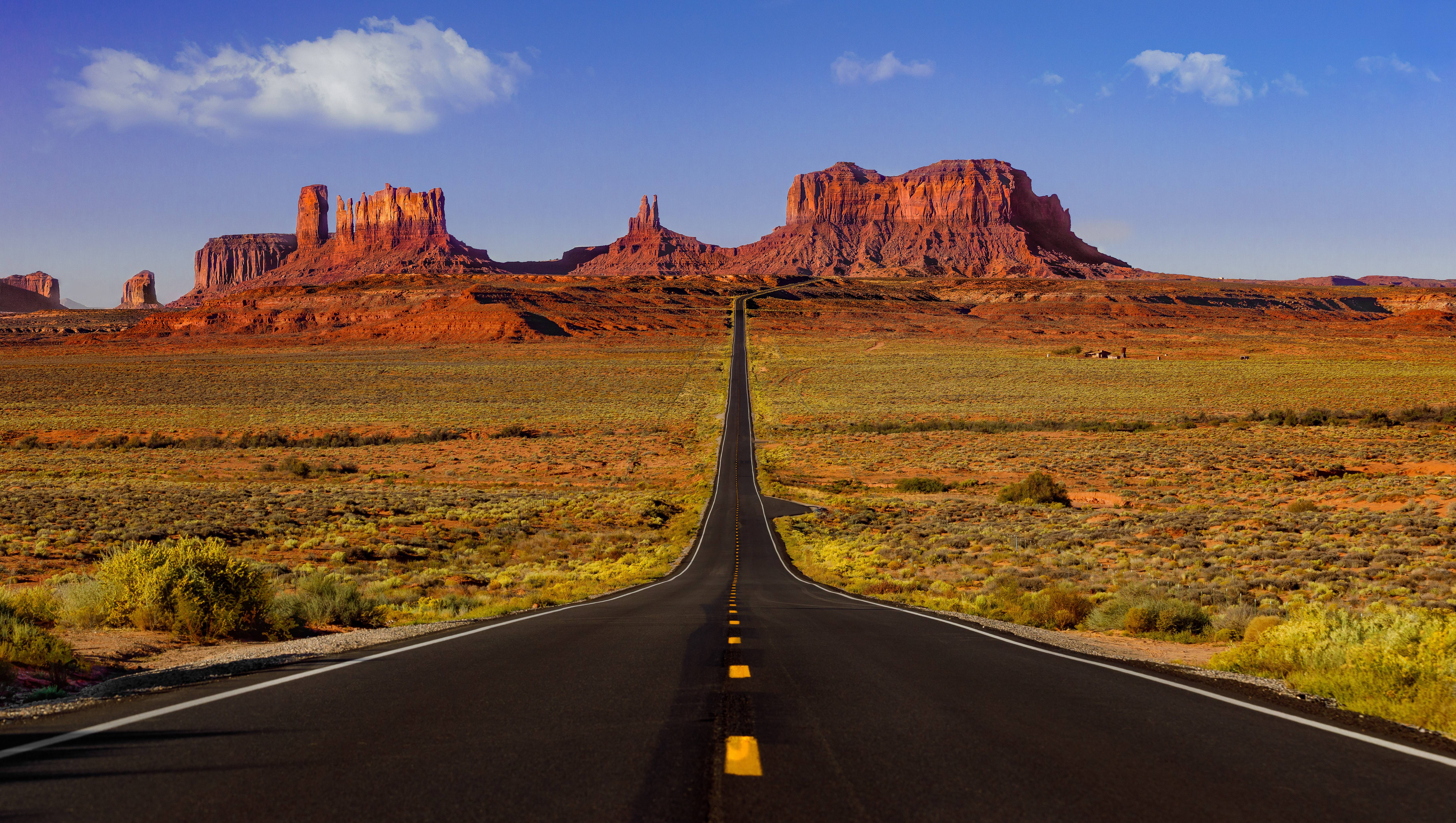
The Landscape That Defined the American West
Monument Valley is the landscape that taught the world what the American West looks like. The sandstone buttes, mesas, and spires that rise as much as 1,000 feet above the high desert floor along the Arizona-Utah border have appeared in so many films, photographs, advertisements, and album covers that even first-time visitors arrive with the sense that they have already been here. Director John Ford filmed Stagecoach here in 1938 and returned again and again for Fort Apache, She Wore a Yellow Ribbon, Rio Grande, and The Searchers, anchoring Monument Valley in the cinematic memory of the West. The valley lies entirely within the Navajo Nation, and the 91,696-acre Monument Valley Navajo Tribal Park is owned and operated by the Navajo people, who have lived here for centuries (and whose name for the place, Tsé Biiʼ Ndzisgaii, means "valley of the rocks"). The buttes are remnants of an enormous sandstone plateau that once covered this entire region, gradually carved away over 50 million years until only the most resistant pinnacles remained. The most iconic formations, the East and West Mittens, stand facing each other like a pair of giant hands, palms inward. The famous 17-mile Valley Drive loops through the park's heart on an unpaved, washboard road, passing 11 named viewpoints. The approach itself, along US-163 between Kayenta and Mexican Hat, is one of the most photographed stretches of pavement in America: the long, straight road framing the buttes ahead is "Forrest Gump Hill," where Forrest finally stopped running in the 1994 film. Monument Valley is sacred ground; visitors are guests on Navajo land, and respect for the people, places, and protocols is part of the experience.
Key Stops
Kayenta The southern gateway, a small Navajo Nation town at the junction of US-160 and US-163 with motels, fuel, restaurants, and the Navajo Cultural Center on the grounds of the Hampton Inn (free, with displays on Navajo Code Talkers, weaving, and silversmithing). Burger King has a particularly good Code Talker exhibit. Last reliable services on the southern approach.
Agathla Peak (El Capitán) Roughly 7 miles north of Kayenta, this 1,500-foot black volcanic plug rises from the desert floor like a thunderhead, the eroded core of an ancient volcano. Sacred to the Navajo, who call it Aghaałą́ ("much wool" or "place of the scraping of fur"), where mythological monsters were said to scrape themselves against the rock. Pull off the highway for photos; do not climb (it is closed to climbing and sacred).
Owl Rock Across US-163 from Agathla Peak, a sandstone spire rises from the edge of Tyende Mesa. The two formations together announce the approach to Monument Valley.
Monument Valley Visitor Center and The View Hotel The visitor center, museum, gift shop, and overlook sit on the canyon rim with the most famous panorama in the park: the East and West Mittens with Merrick Butte between them. The View Hotel, adjacent and Navajo-owned, has rooms whose private balconies look directly at the Mittens; the restaurant offers Navajo specialties (mutton stew, fry bread). Park entry is $8 per person (cash or card; Navajo Tribal Parks fee, separate from National Park passes, which are not accepted here). Open daily, hours vary seasonally.
Valley Drive (17-mile Self-Guided Loop) The park's signature experience: an unpaved, rough, dusty 17-mile loop with 11 numbered viewpoints. Allow 2 to 4 hours. Stops include:
- Mitten View (Stop 1): The opening panorama with East and West Mittens and Merrick Butte
- Elephant Butte (Stop 3): A massive butte with the silhouette of an elephant
- The Three Sisters (Stop 4): Three slender spires
- John Ford's Point (Stop 5): The director's favorite viewpoint, with sweeping views and (typically) a Navajo guide and horse available for the classic "cowboy on the cliff edge" photograph (small tip expected)
- Camel Butte (Stop 6)
- The Hub (Stop 7): A central viewpoint with 360-degree views
- Totem Pole and Yei Bi Chei (Stop 8): The Totem Pole is a needle-thin spire 450 feet tall; Yei Bi Chei is a cluster of pinnacles resembling Navajo dancers in ceremonial procession
- Sand Spring (Stop 9)
- Artist's Point (Stop 10): A wide overlook beloved by painters and photographers
- North Window (Stop 11): A natural rock window framing more buttes beyond
The road has steep, rough sections, deep sand, and washboard surfaces. Standard passenger cars can complete the loop in dry weather, but high-clearance vehicles are strongly recommended.
Navajo-Guided Tours (Beyond Valley Drive) Many of the valley's most extraordinary places are off-limits to self-driving visitors and can be reached only with a Navajo guide. Tours range from 1.5 hours to full days and visit Mystery Valley, Hunts Mesa (for sunrise/sunset on the buttes), petroglyphs, hogans, and Anasazi ruins. Operators include Monument Valley Tours, Sacred Monument Tours, and Goulding's Tours. Pricing varies; book ahead, especially in spring and fall.
Goulding's Trading Post and Lodge Two miles west of US-163, the historic trading post founded by Harry and "Mike" Goulding in 1923. The Gouldings convinced John Ford to film Stagecoach here in 1938, transforming Monument Valley from a remote corner of the Navajo Nation into a Hollywood icon. The original trading post is now a museum with film memorabilia, Navajo artifacts, and the cabin used by John Wayne. Goulding's Lodge offers rooms, a restaurant, a campground, and tour services. Open year-round.
Forrest Gump Hill (US-163 Mile Marker 13) A long, straight stretch of US-163 with the buttes framed perfectly down the road ahead, made famous as the spot where Forrest finally stopped running in the 1994 film. Now one of the most photographed locations in the American Southwest. There is no official pullout; a wide shoulder has been informally adopted by visitors. Use extreme caution: drivers stopping mid-road for photos have caused fatal accidents. Pull entirely off the pavement and step well clear of traffic.
Mexican Hat (Northern Approach) A tiny Utah settlement named for a balanced rock formation just north of town that resembles an inverted sombrero. The town has fuel, a few motels, and the legendary San Juan Inn perched on the cliff edge above the San Juan River. The Swinging Steaks restaurant serves T-bones on a swinging grill.
Goosenecks State Park (Side Trip) Eight miles west of Mexican Hat via UT-261 and UT-316. The San Juan River carves a 1,000-foot-deep series of entrenched meanders, winding back and forth so tightly that the river covers 6 miles to make 1.5 miles of westward progress. One of the finest examples of entrenched meanders in the world. Entry $5 per vehicle.
Moki Dugway and Muley Point (Side Trip) North of Goosenecks, UT-261 climbs the Cedar Mesa cliff face via the Moki Dugway: three miles of unpaved switchbacks (grades up to 10 percent, 1,100 feet of climb) carved by uranium miners in the 1950s. Not for the faint of heart, but standard vehicles in dry weather can manage it. From the top, an unpaved 5-mile spur leads to Muley Point, an undeveloped overlook with one of the most arresting panoramas in the entire Southwest: the Goosenecks of the San Juan twisting 1,000 feet below, Monument Valley's buttes on the horizon, and the Henry Mountains beyond. No fee, no facilities.
Valley of the Gods (Side Trip) A 17-mile unpaved loop east of UT-261, often described as a "miniature Monument Valley" with similar red sandstone buttes, towers, and balanced rocks but few other visitors. Free, no permits required. Suitable for high-clearance vehicles in dry weather.
Driving Tips
- The Monument Valley Navajo Tribal Park is owned and operated by the Navajo Nation, not the National Park Service. The $8-per-person entry fee is collected at the visitor center entrance. National Park passes are not valid here.
- The 17-mile Valley Drive is unpaved, rough, and dusty. Standard passenger cars can complete it in dry weather but with significant wear; many rental car contracts prohibit driving on unpaved roads. High-clearance SUVs are strongly recommended. After rain, the road becomes slippery clay and may be temporarily closed.
- For the most memorable experience, take a Navajo-guided tour to reach Mystery Valley, Hunts Mesa, and sites beyond the public road. Tour operators include Goulding's Tours, Monument Valley Tours, and Sacred Monument Tours.
- Navajo Nation observes Daylight Saving Time (Mountain Time, MDT/MST), unlike the rest of Arizona, which stays on MST year-round. Confirm time before arriving for tours; you may gain or lose an hour crossing the AZ-UT border or entering the Navajo Nation.
- Photography of Navajo people and homes (hogans) requires permission. Always ask before taking pictures of people, animals, or private dwellings. Tipping is appreciated.
- Alcohol is prohibited on the Navajo Nation. Do not bring or consume alcohol within tribal lands.
- The View Hotel and Goulding's Lodge are the only lodging directly at the valley. Book months ahead, especially for spring and fall. Kayenta (south) and Mexican Hat (north) have additional motels.
- Fuel up in Kayenta or Mexican Hat. The visitor center has a small grill but no fuel. Goulding's has a small store and fuel pumps.
- Cell coverage is spotty within the tribal park and limited along US-163. Download offline maps.
- Best photography light is at sunrise (East Mitten lit, West Mitten in shadow) and sunset (West Mitten lit). The full moon rising over the Mittens is spectacular; check lunar calendars when planning.
- Summer temperatures regularly exceed 100°F with little shade. Carry water. Winter brings occasional snow and ice; the Valley Drive may close temporarily.
- Forrest Gump Hill is on a public highway. Park entirely off the pavement on the shoulder and watch for traffic; serious accidents have occurred at this spot.
- For more information visit: Navajo Nation Parks: Monument Valley