Michigan Upper Peninsula
America's Wildest North Woods, Between Three Great Lakes
Michigan's Upper Peninsula (the "UP") is one of the wildest, emptiest, and least-known corners of the contiguous United States: 16,452 square miles of forest, granite, copper, sand, and water, separated from the rest of Michigan by the 5-mile Straits of Mackinac and bordered by three of the five Great Lakes. With a population of just 300,000 across an area larger than Massachusetts, Connecticut, and New Jersey combined, the UP averages 18 people per square mile (compared with Lower Michigan's 175) and contains one of the largest concentrations of wild forest in the eastern United States. The peninsula was carved by Pleistocene glaciers from some of the oldest rock on Earth (the Canadian Shield's Precambrian bedrock, over 2 billion years old, surfaces in the western UP and contains some of the richest copper deposits ever found anywhere; the Keweenaw Peninsula produced over 11 billion pounds of copper between 1845 and 1968, fueling the Industrial Revolution). The shoreline holds three of the world's great freshwater coasts: Lake Superior along the north (the largest freshwater lake on Earth by surface area, 31,700 square miles, 1,332 feet deep, holding 10 percent of the world's surface fresh water), Lake Michigan along the south, and Lake Huron at the eastern end. The peninsula has been home to the Ojibwe (Anishinaabe) and Menominee peoples for at least 12,000 years and was the heart of the French fur trade after 1671 (Father Marquette founded Sault Ste. Marie in 1668, the third-oldest continuously occupied European settlement in the United States). The drive crosses the Mackinac Bridge (the third-longest suspension bridge in the world when opened in 1957), follows the Lake Superior Circle Tour along Whitefish Bay to Pictured Rocks National Lakeshore (40 miles of multi-colored sandstone cliffs rising 200 feet directly from Lake Superior), continues to the iron-mining city of Marquette, climbs north onto the Keweenaw Peninsula (a 70-mile finger of copper country jutting into Lake Superior, reaching its scenic finale at the dead-end harbor of Copper Harbor), drops south to the Porcupine Mountains Wilderness State Park (the largest tract of old-growth hardwood-hemlock forest west of the Adirondacks), and returns east along Lake Michigan via Escanaba and the Hiawatha National Forest. The drive crosses two distinct cultural worlds: the eastern UP (closer to French-Canadian and Finnish heritage, with strong Native American presence) and the western UP (the so-called "Copper Country" of Finnish, Cornish, and Italian immigrants who came for the mines). The drive's signature dish is the pasty (a Cornish meat-and-vegetable hand-pie, brought by Cornish miners in the 1840s, now a UP icon). Locals call themselves "Yoopers" and the Lower Peninsula "trolls" (because they live "under the bridge").
Key Stops
Mackinac Bridge (Start) The 5-mile suspension bridge between Mackinaw City (Lower Peninsula) and St. Ignace (Upper Peninsula) opened in 1957 after decades of failed attempts ("the bridge that couldn't be built"). Designed by Dr. David B. Steinman, "Mighty Mac" was the longest suspension bridge in the Western Hemisphere when built and remains the third-longest. Toll $4 per car. On Labor Day, 40,000 walkers cross during the annual Mackinac Bridge Walk, the only day pedestrians are permitted.
St. Ignace Founded by Father Jacques Marquette in 1671, the second-oldest European settlement in Michigan and one of the oldest in the United States. Marquette's grave is reportedly in the Museum of Ojibwa Culture, built on the site of his original mission. Ferry services to Mackinac Island operate from here. St. Ignace has shops, restaurants, motels, and the iconic Bridge View Park.
Sault Ste. Marie Michigan's oldest city (founded by Father Marquette in 1668, the third-oldest continuously occupied European settlement in the United States) and home to the Soo Locks, the largest waterway traffic system in the world. Roughly 7,000 freighters pass through each year, lowering 21 feet from Lake Superior to Lake Huron (the largest single lockage drop in the world). Key sites:
- Soo Locks Visitor Center with free observation deck (you can watch 1,000-foot ore freighters lock through within touching distance)
- Soo Locks Boat Tours, a 2-hour cruise through both Michigan and Canadian locks ($35 per adult)
- Museum Ship Valley Camp, a permanently moored 1917 ore freighter open for tours, with extensive Edmund Fitzgerald memorabilia
- Tower of History, a 21-story observation tower
- Bridge to Canada (Sault Ste. Marie, Ontario) just across the St. Marys River
Tahquamenon Falls State Park The peninsula's most-visited natural attraction, where the tannin-stained Tahquamenon River (Longfellow's "rushing Tahquamenaw" in The Song of Hiawatha) creates two spectacular waterfalls:
- Upper Tahquamenon Falls: 200 feet wide, 50 feet tall, dumping up to 50,000 gallons per second in a copper-orange-colored arc. The second-largest waterfall east of the Mississippi after Niagara. Multiple observation platforms; the Brink of the Falls trail descends 116 steps to a viewing platform inches from the lip.
- Lower Tahquamenon Falls: A series of five smaller cascades around a small island, reachable by rowboat rental in season.
The water gets its color from tannins leached from the cedar swamps upstream, not pollution. State park entry $11 per vehicle. The Tahquamenon Falls Brewery and Pub at the Upper Falls is the only brewery in a Michigan state park.
Whitefish Point and the Great Lakes Shipwreck Museum The treacherous Whitefish Bay is the "Graveyard of the Great Lakes," where over 240 vessels have sunk. The Great Lakes Shipwreck Museum preserves the original 1849 Whitefish Point Light Station and tells the stories of the most famous wrecks, including the SS Edmund Fitzgerald (lost November 10, 1975, with all 29 hands; immortalized in Gordon Lightfoot's 1976 song "The Wreck of the Edmund Fitzgerald"). The museum displays the actual bronze bell recovered from the Fitzgerald's pilothouse in 1995 (replaced on the wreck with a memorial bell engraved with the names of those lost). Admission $15. Whitefish Point is also one of the premier birding spots in the eastern US: a narrow peninsula that funnels migrating raptors, songbirds, and waterfowl, with over 340 species recorded.
Grand Marais A tiny harbor village on Lake Superior at the eastern entrance to Pictured Rocks. The Au Sable Light Station (1874) is reached by a beach hike from the Hurricane River Campground in Pictured Rocks. The Log Slide Overlook offers spectacular views of the Grand Sable Dunes plunging 300 feet into Lake Superior (lumberjacks once used this slide to dump pine logs straight into the lake; do not slide down or you face a brutal climb back up).
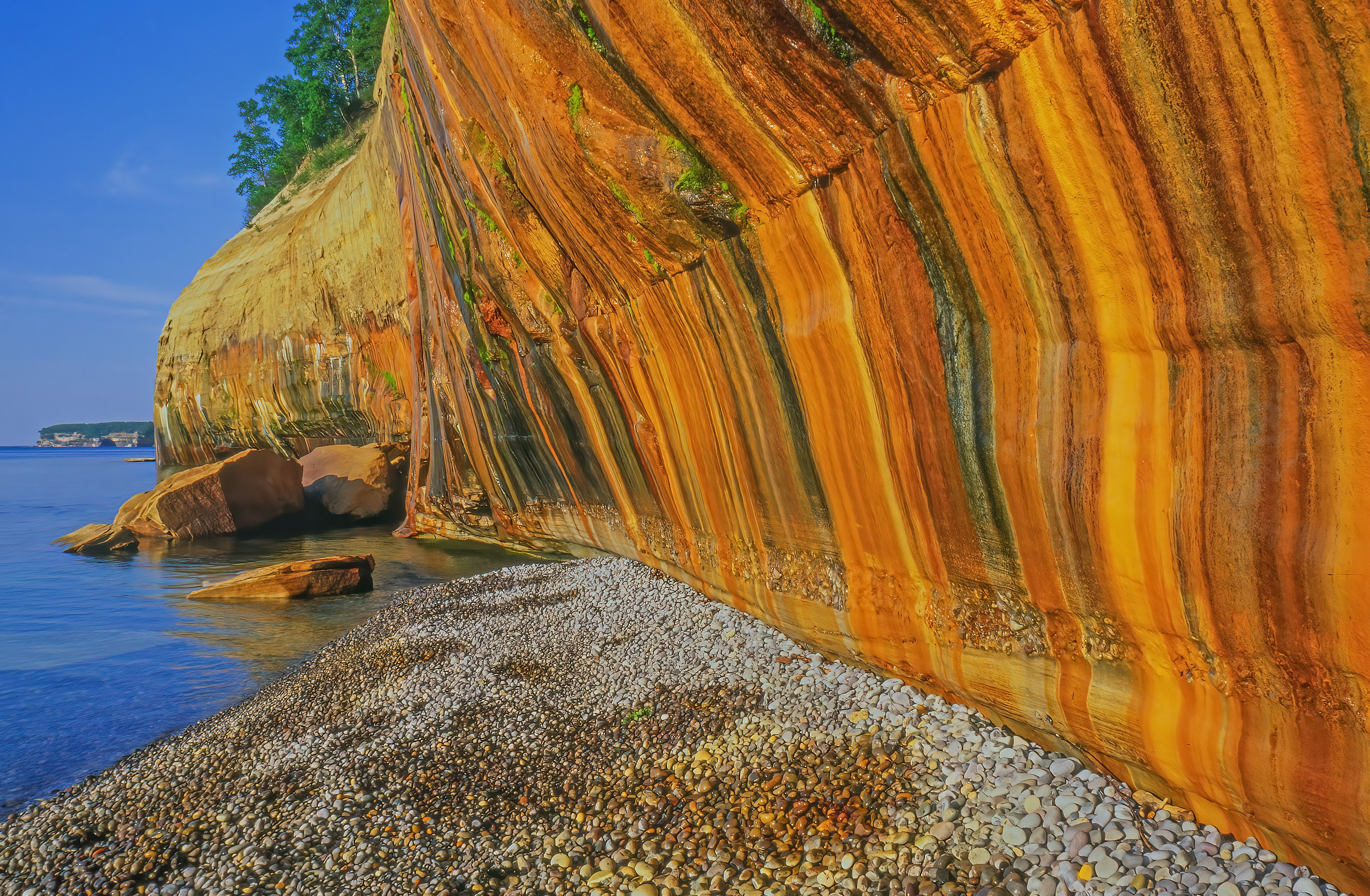
Pictured Rocks National Lakeshore The drive's natural centerpiece: 40 miles of Lake Superior shoreline preserving multi-colored sandstone cliffs that rise up to 200 feet directly from the water, painted in shades of red (iron), green (copper), blue (cobalt), and white (limestone) by mineral-rich groundwater seeping through the rock. Pictured Rocks was America's first National Lakeshore (designated 1966). Best seen by water:
- Pictured Rocks Cruises from Munising offer 2.5-hour boat tours ($45 per adult, May–October)
- Kayak tours with several outfitters get you under the arches and into the sea caves
- Glass-bottom boat tours explore shipwrecks in the clear waters of Munising Bay
Land-based highlights:
- Miners Castle, a 9-story-tall rock formation (a section collapsed in 2006, leaving only one of its original two turrets; the rock is still falling)
- Miners Beach and Miners Falls
- Chapel Rock, Chapel Beach, and Chapel Falls
- Munising Falls, a 50-foot cascade reached by a paved 800-foot trail
Munising is the western gateway with full services. Park entry is free; the visitor center is open year-round.
Marquette The largest city in the Upper Peninsula (population approximately 21,000) and the cultural and economic center of the central UP. Marquette is built on the iron-mining industry: between 1850 and 2010, the Marquette Iron Range produced more iron ore than any other region in North America. Key sites:
- Marquette Lighthouse (1866) and the Maritime Museum
- Presque Isle Park, a 323-acre wooded peninsula jutting into Lake Superior with Black Rocks (popular for cliff-jumping into the lake in summer)
- Sugarloaf Mountain, a granite outcrop with a 470-foot trail to a panoramic Lake Superior overlook
- Northern Michigan University campus with the impressive Beaumier Heritage Center
- Marquette Mountain Ski Area and (in summer) downhill mountain biking
- Excellent local breweries (Blackrocks Brewery, Ore Dock Brewing) and the Vango's pizza institution
Marquette is the staging point for trips to the Huron Mountain Range (one of the largest privately preserved tracts of old-growth forest in the eastern US, owned by the Huron Mountain Club).
Keweenaw Peninsula A 70-mile copper-country peninsula thrusting north into Lake Superior, the geological and human heart of America's first mining boom. Between 1845 and 1968, the Keweenaw produced over 11 billion pounds of native copper (more than 99 percent pure, the only large deposit of native copper on Earth), supporting industries from telegraph wire to the Statue of Liberty. The boom built ornate Victorian opera houses and immigrant neighborhoods of Finnish, Cornish, and Italian workers. Key stops:
- Houghton and Hancock, the twin cities at the Portage Canal (a man-made waterway cutting across the peninsula, allowing freighters to take a shortcut). Houghton is home to Michigan Technological University and the ferry to Isle Royale National Park.
- Quincy Mine, on the bluff above Hancock, with mine shaft tours descending 7 levels (over 92 levels below the surface; one of the deepest copper mines in the world). The Hoist House contains the world's largest steam hoist engine.
- Calumet, the heart of the historic Copper Country: a downtown of 19th-century brick storefronts so well-preserved that the entire town is a National Historical Park (Keweenaw National Historical Park, established 1992). The Calumet Theatre (1900) was one of the finest opera houses in the Midwest.
- Eagle River and Eagle Harbor, tiny Lake Superior fishing villages with historic lighthouses
- Brockway Mountain Drive, a 9-mile road climbing to 735 feet above Lake Superior with one of the finest Great Lakes panoramas
- Copper Harbor at the tip of the peninsula: a remote village (year-round population approximately 100) with Fort Wilkins Historic State Park (an 1844 frontier military post), the Copper Harbor Lighthouse (reached by boat tour), and the Keweenaw Mountain Lodge. The ferry Isle Royale Queen IV departs from here for Isle Royale National Park (one of the least-visited national parks; the only national park entirely closed in winter; the only national park in the United States entirely within Lake Superior).
Porcupine Mountains Wilderness State Park (the "Porkies") Michigan's largest state park (60,000 acres) and the largest tract of old-growth northern hardwood-hemlock forest west of the Adirondacks. Some sugar maple, hemlock, and yellow birch are over 500 years old. The "Porkies" rise 1,000 feet above Lake Superior, with classic mountain lake-and-forest scenery uncharacteristic of the Midwest. Key sites:
- Lake of the Clouds Overlook, the iconic Porkies view: a long oval lake surrounded by old-growth forest 300 feet below an escarpment, with rolling forested mountains stretching to Lake Superior in the distance
- Summit Peak Observation Tower (1,958 feet, the highest point in the Porkies)
- Presque Isle River along the western boundary, with a chain of waterfalls accessible by trail
- Union Spring, the second-largest natural spring in Michigan
- 87 miles of trails, including the rugged Escarpment Trail with continuous old-growth and Lake of the Clouds views
State park entry $11 per vehicle. Rustic cabins and yurts (book months in advance through Michigan DNR).
Iron Mountain and the Iron Range Inland on the southern leg of the loop, the Iron Range towns of Iron Mountain, Iron River, and Crystal Falls preserve mining history. The Iron Mountain Iron Mine offers underground mine tours.
Fayette Historic State Park On the Garden Peninsula (a southern finger of the UP extending into Lake Michigan), the preserved iron-smelting company town of Fayette operated 1867–1891, producing pig iron from local ore. Now restored as a state park with original limestone buildings, a hotel, a hotel cemetery, and a museum. Set against 90-foot limestone cliffs on a quiet bay.
Kitch-iti-kipi (Palms Book State Park) "Mirror of Heaven," Michigan's largest natural freshwater spring: 40 feet deep, 200 feet wide, with crystal-clear water (visibility to the bottom year-round) and a constant temperature of 45°F. A self-operating wooden raft (pulled along a guide cable) crosses the spring with observation windows in the floor, providing a remarkable view down through swimming trout to limestone-coated fallen logs at the bottom. State park entry $11.
Hiawatha National Forest and Cut River Bridge The drive returns east on US-2 along the southern UP through Hiawatha National Forest (894,000 acres in two units, spanning the peninsula from Lake Superior to Lake Michigan). The Cut River Bridge rises 147 feet above the Cut River gorge, one of the most spectacular highway bridges in the Midwest. Trails descend from each end of the bridge.
Return to Mackinaw City via St. Ignace The loop closes by recrossing the Mackinac Bridge to the Lower Peninsula.
Driving Tips
- Allow 7 to 10 days to complete the full loop. The UP is much larger and emptier than visitors expect. Major overnight bases: Sault Ste. Marie or Paradise (1 night), Munising (1–2 nights), Marquette (1 night), Copper Harbor (1–2 nights), Porcupine Mountains (1 night), Escanaba/Manistique (1 night).
- The drive is paved throughout, but some roads (especially in the Porkies and the Keweenaw) are narrow and winding. Watch for moose on roads north of US-2 (the UP's small moose population is making a recovery; collisions are devastating).
- Cell coverage is reliable in towns and along main highways but largely nonexistent across vast forested stretches, especially in the Porkies, the Keweenaw interior, and on M-28 through Seney. Download offline maps. Carry paper backup. Tell someone your itinerary.
- Fuel up at every opportunity. Long stretches between gas stations are normal; the run from Houghton to Copper Harbor is the most remote on the route.
- Pasties are an institution. Try one in any UP town; Lehto's Pasties (St. Ignace), Muldoons (Munising), Mackinaw Trail Winery (Manistique), Toni's Country Kitchen (Laurium), and Connie's Kitchen (Marquette) are local favorites.
- Pictured Rocks Cruises sell out in summer; reserve in advance. Kayak tours and glass-bottom shipwreck tours are equally worthwhile if you want a different angle.
- Tahquamenon Falls is most spectacular at high water (May–June) and in fall foliage season (late September to early October).
- Mackinac Island is best as an overnight: take the ferry from St. Ignace or Mackinaw City, leave your car, and stay at the Grand Hotel, Mission Point Resort, or one of the smaller inns. No cars allowed; horse-and-buggy and bicycle only.
- Isle Royale National Park (a 6-hour ferry ride from Copper Harbor or 1.5-hour seaplane flight) is one of America's most pristine wildernesses but requires advance planning. Day trips are possible from Copper Harbor; backpacking requires 4–5 days minimum.
- Fall foliage peaks late September in the western and northern UP, early October in the eastern UP. The drive is spectacular at peak.
- Mosquitoes and blackflies are notorious in late May, June, and early July. Bring strong DEET-based repellent.
- Winter transforms the UP into one of the snowiest places in the United States (the Keweenaw averages 240+ inches of snow annually). The drive remains possible but requires winter tires, traction devices, emergency supplies, and experience driving in heavy snow. Lake-effect storms can produce whiteouts. December–March is also prime aurora season.
- Lake Superior is dangerously cold year-round (typically 35–55°F). Swim only at designated beaches in warm conditions. Rip currents and sudden temperature drops have caused multiple fatalities.
- For more information visit: Central Upper Peninsula | Michigan