Lake Tahoe Full Loop
72 Miles of Blue Perfection
Lake Tahoe sits at 6,225 feet in the Sierra Nevada, straddling the California-Nevada border — 22 miles long, 12 miles wide, and 1,645 feet deep, holding enough water to cover the entire state of California to a depth of 14 inches. The 72-mile loop that circles it passes through two states, crosses multiple climate zones, and delivers a continuously shifting panorama of cobalt water, granite peaks, and dense evergreen forest that makes it one of the most celebrated scenic drives in the American West. The east shore follows the Lake Tahoe National Scenic Byway through tunnels carved into Cave Rock and past the crystal-clear coves of Sand Harbor. The north shore threads through the resort communities of Incline Village, Crystal Bay, and Kings Beach. The west shore traces SR-89 along a quieter, more rugged coastline to Emerald Bay — a glacier-carved inlet often called the most photographed spot in North America. And the south shore delivers the urban energy of Stateline's casinos and the Heavenly Mountain Gondola rising 2.4 miles above it all. The water's legendary clarity — you can see to depths of 70 feet — and its impossible shade of blue tie the entire circuit together.
Key Stops
Heavenly Mountain Gondola (South Lake Tahoe) Start the loop with a bird's-eye perspective. The eight-passenger glass gondola climbs 2.4 miles to an observation deck at 9,123 feet, with panoramic views spanning the lake, Carson Valley, and the Sierra crest. On a clear day you can see 100 miles in every direction. Adults $63, children $32; open 8:30 AM–4:00 PM seasonally. The Heavenly Village at the base has restaurants, shops, and the casino corridor is steps away.
Zephyr Cove (US-50, East Shore) Four miles north of Stateline on US-50, Zephyr Cove Resort is the home port of the M.S. Dixie II, a 500-passenger paddlewheeler offering daytime scenic cruises and dinner cruises on the lake. The resort also has a sandy beach, horseback riding, and seasonal snowmobile tours. The cove's wide crescent of sand and calm water make it one of the lake's best swimming beaches.
Cave Rock (US-50, East Shore) Continuing north, the highway passes through two tunnels blasted directly through this massive volcanic formation — a site sacred to the Washoe people, who call it De ek Wadapush. The boat launch on the lake side offers sandy beach access, swimming, and snorkeling in water so clear the bottom is visible from the surface. A geological and cultural landmark unlike anything else on the loop.
Sand Harbor (Nevada State Park) Widely regarded as the most beautiful beach on Lake Tahoe. Turquoise water laps against smooth granite boulders along three distinct beach areas, backed by Jeffrey pines. Sand Harbor hosts the Lake Tahoe Shakespeare Festival each July and August, with performances against the backdrop of the lake at sunset. Day-use reservations are now required April 15–October 15 (book 90 days ahead at ReserveNevada.com, $15/vehicle for non-Nevada plates). The beach fills by mid-morning without a reservation.
Thunderbird Lodge (East Shore) Hidden on the east shore between Sand Harbor and Incline Village, this 1930s stone estate built by eccentric casino mogul George Whittell Jr. features a 600-foot tunnel connecting the main lodge to a boathouse on the lake. Guided tours (by reservation only, June–mid-October) reveal the lighthouse, elephant room, and servant quarters. Access is by shuttle only — no private vehicles. Land tours Tuesday and Friday mornings; water tours by boat from Tahoe Keys Marina ($135/adult).
East Shore Trail Opened in 2019 and dubbed "America's Most Beautiful Bikeway," this 3-mile paved, ADA-accessible trail connects Sand Harbor to Incline Village along the previously inaccessible east shore, with continuous lake views through old-growth forest. Open year-round for walking, running, and cycling. A future extension to Spooner Summit is planned.
Incline Village & Crystal Bay (North Shore) Incline Village is the upscale resort community on the Nevada side, home to Diamond Peak ski resort (celebrating its 60th anniversary in 2025-26, lift tickets from $137) and two championship golf courses. Crystal Bay, straddling the state line, marks the historic site of the Cal-Neva Resort, where Frank Sinatra once held court. The transition from Nevada's north shore to California's Kings Beach is seamless — a continuous strip of lakefront restaurants, shops, and summer concert series.
Kings Beach (North Shore) Nearly 1,000 feet of sandy public beach at Kings Beach State Recreation Area, with summer evening concerts (Music on the Beach, Friday evenings) and calm, swimmable water. The town has a relaxed, less polished feel than the south shore — local taco shops, ice cream stands, and kayak rentals line the main road.
Tahoe City (West Shore) The Truckee River begins here at Lake Tahoe's only outlet, flowing over a dam visible from the newly rebuilt Fanny Bridge (reopened February 2026 after a $10.6 million replacement). The name comes from visitors who lean over the railing to watch the trout below. Commons Beach, a waterfront park just south of the bridge, hosts a summer concert series and has picnic areas and a playground. Tahoe City is the gateway to the quieter west shore.
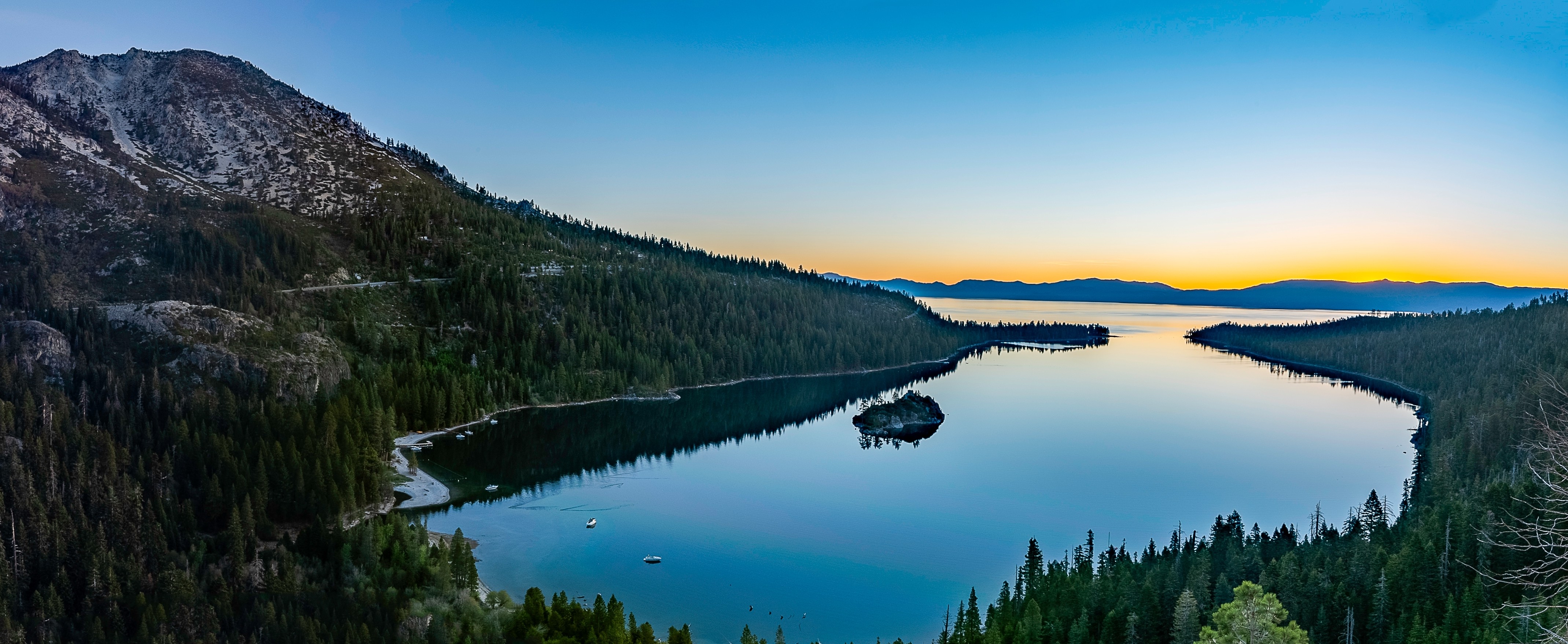
Emerald Bay State Park (West Shore) The crown jewel of the loop. A glacier carved this bay into the southwest shore during the last ice age, leaving a natural amphitheater of granite walls, a small island (Fannette Island, the lake's only island), and water that glows emerald green from the shallows over a light-colored sandy bottom. Inspiration Point, a pullout along SR-89, offers the classic postcard view. A steep one-mile trail descends to Vikingsholm, a 1929 Scandinavian-style castle built of local granite without cutting a single tree — considered one of the finest examples of Scandinavian architecture in the Western Hemisphere. Guided tours run mid-June through September (currently under restoration with modified access). The short trail to Lower Eagle Falls begins at the parking area. A shuttle service launched in 2025 helps manage chronic parking overflow.
Driving Tips
- Direction: Drive clockwise (east on US-50 from South Lake Tahoe) to stay on the lake side of the road for the best views at every turn.
- Parking: Emerald Bay and Sand Harbor are the two most critical bottlenecks. Sand Harbor now requires day-use reservations April 15–October 15 (book at ReserveNevada.com, 90 days ahead). Emerald Bay has a new shuttle service (daily 9 AM–5 PM, mid-July through mid-October) and a parking restriction pilot program — arrive early or use the shuttle.
- West shore (SR-89): Periodic construction for the West Shore Bike Trail Rehabilitation continues into 2026, with occasional one-way traffic control. Check conditions at TahoeRoads.info.
- Winter driving: Tire chains are required on all vehicles during California chain-control periods (R-2 and R-3). SR-89 through Emerald Bay can close temporarily during heavy snowstorms. AWD/4WD with snow tires is strongly recommended November through April. Check Caltrans at 800-427-7623.
- Cell service: Good coverage in South Lake Tahoe, Incline Village, and Kings Beach (Verizon and AT&T best). The west shore along SR-89 has significant dead zones — download offline maps before departing.
- EV charging: Concentrated in South Lake Tahoe and the casino corridor (94 stations including DC fast chargers at Golden Nugget and Stateline properties). Tesla Superchargers available in Truckee. The west shore has very limited charging — plan accordingly.
- Fuel: Available in South Lake Tahoe, Tahoe City, Kings Beach, and Incline Village. No gas stations along the west shore between Tahoe City and South Lake Tahoe.
- Two states, two sets of rules: California and Nevada have different speed limits, chain requirements, and state park fees. Sand Harbor (Nevada) and Emerald Bay (California) charge separate entrance fees.
- For more information visit: Visit Lake Tahoe