Illinois River Road
Central Illinois's Wildlife Corridor, From Starved Rock to Havana
The Illinois River Road is the most underrated National Scenic Byway in the Midwest, a 291-mile loop along both banks of the Illinois River through central Illinois, designated a National Scenic Byway in 2005 for its outstanding natural, cultural, and historic values. The Illinois River is the largest tributary of the Mississippi by drainage area, flowing 273 miles from its formation at the confluence of the Kankakee and Des Plaines Rivers near Joliet to its mouth at Grafton, where it joins the Mississippi. The river became the great water road of the early French exploration of North America: in 1673, Jesuit missionary Jacques Marquette and fur trader Louis Jolliet ascended the Illinois on their return from the first European voyage down the Mississippi, traveling through one of the largest concentrations of Native American settlements on the continent. The Illinois Confederacy, a dozen Algonquian-speaking tribes including the Peoria, Kaskaskia, Cahokia, and Tamaroa, lived along the river in towns of thousands; the city of Peoria was founded near the site of the Peoria tribal capital, and the Illini Confederacy gave the state its name. The byway also follows the route of the Illinois & Michigan Canal (built 1836–1848, connecting the Great Lakes to the Mississippi River system and effectively making Chicago possible) and passes through some of the most important Native American mound sites in the Midwest. Today the river corridor is a flyway of continental importance: the Illinois River Valley is the most important stopover for migrating waterfowl in the Mississippi Flyway, hosting roughly 80 percent of the white pelicans passing through North America each fall, hundreds of thousands of ducks and geese, and (in winter) the largest concentration of wintering bald eagles in the Midwest outside Alaska, perhaps 4,000 to 5,000 birds along the river between Ottawa and Grafton. The drive crosses three National Wildlife Refuges, two of America's most-visited state parks, the headquarters of Caterpillar Inc., and the towns of Lincoln's circuit-lawyer days (Abraham Lincoln practiced law in Peoria, Pekin, Metamora, Lacon, and Havana during the 1840s and 1850s, walking many of the same streets visitors walk today). The scenery is gentler than Western mountain drives—wide river bottoms framed by limestone bluffs up to 200 feet high, oak-hickory woodlands, restored wetlands, and prairie remnants—but the wildlife concentrations, layered human history, and uncrowded byways make this one of the great undiscovered scenic drives in America.
Key Stops
Ottawa (Northern Gateway) A historic small city at the confluence of the Illinois and Fox Rivers, founded in 1830 and famous as the site of the first Lincoln-Douglas debate (August 21, 1858, in Washington Square, the start of the seven-debate Senate campaign that launched Lincoln's national career). The Lincoln-Douglas Debate Square preserves the actual debate site with statues of the candidates. Ottawa was also a critical port on the Illinois & Michigan Canal, the engineering marvel that connected the Great Lakes to the Gulf of Mexico via the Mississippi River system, opened in 1848. Reddick Mansion (1858) is an Italianate-style museum with original period furnishings. Full services.
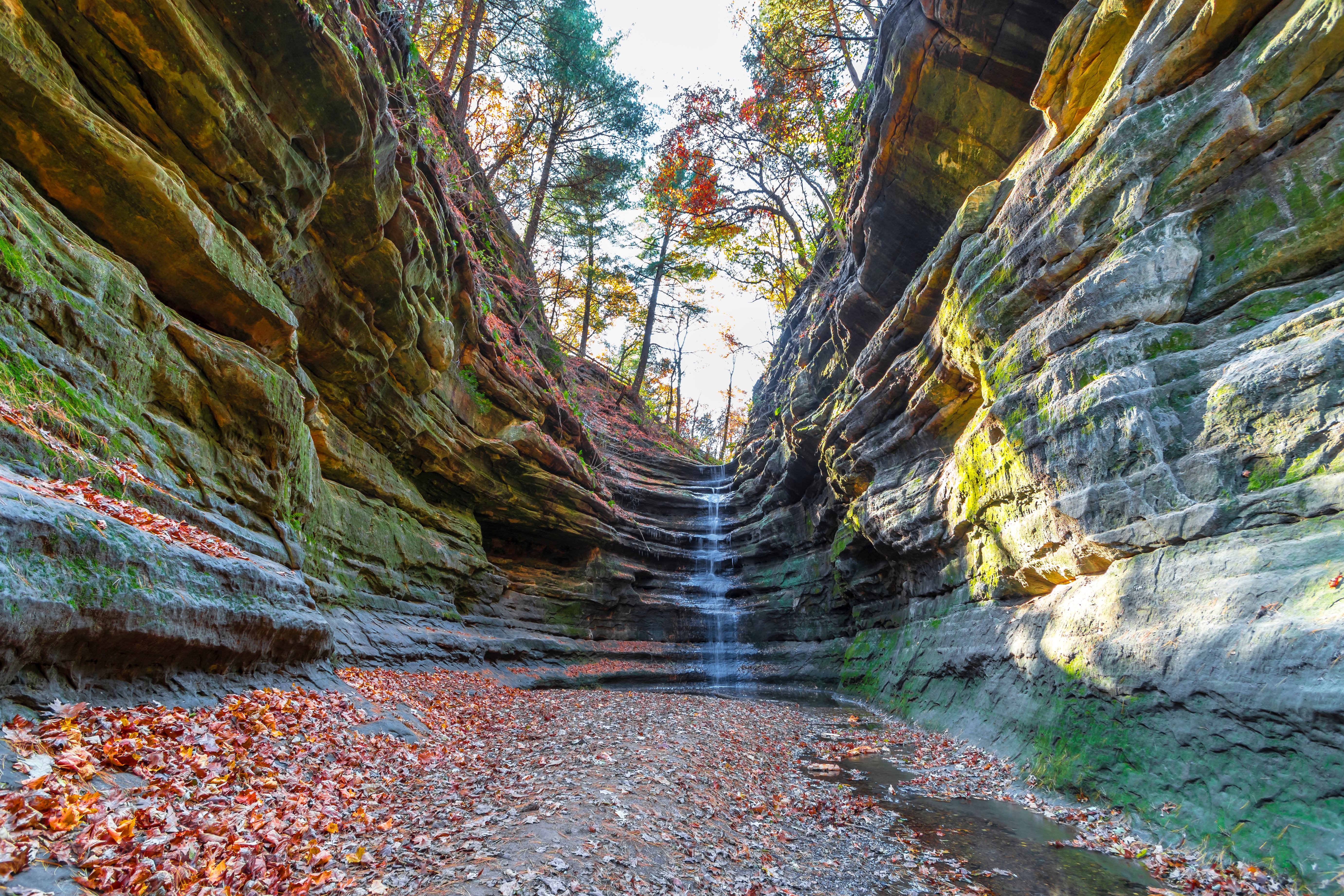
Starved Rock State Park Three miles south of Ottawa across the river, Starved Rock is one of Illinois's most popular state parks, with over 2 million visitors a year. The park sits on a series of 125-foot sandstone canyons carved by tributary streams flowing into the Illinois River. 18 canyons with waterfalls (best in spring after rain or in winter when they freeze into towering blue ice formations), 13 miles of trails, and the namesake Starved Rock itself, a 125-foot sandstone butte where, according to legend, a band of Illini warriors took refuge from a Potawatomi-Ottawa-Ojibwa attack in the 1760s and either starved to death or perished defending the rock. The Starved Rock Lodge (1939, CCC-built of giant logs, with a massive stone fireplace) is one of the great Depression-era national park lodges and operates year-round. Eagle viewing is excellent along the Illinois River below the rock from December through February. Free park entry; lodge rooms book months in advance.
Matthiessen State Park Adjacent to Starved Rock, Matthiessen is the smaller, quieter alternative with its own series of sandstone canyons, waterfalls, and a recreated frontier-era fort. The canyon trail loops through the Upper Dells and Lower Dells past sandstone cliffs and a 45-foot waterfall.
Peru and LaSalle Twin cities west of Starved Rock at the head of navigable shipping on the Illinois River and the western terminus of the original Illinois & Michigan Canal. The Lock 16 Visitor Center in LaSalle (in a restored canal building) explains the I&M Canal's history and offers mule-drawn canal boat rides on a restored section.
I&M Canal State Trail and Hennepin Canal The 61-mile Illinois & Michigan Canal State Trail runs along the historic canal towpath from LaSalle to Channahon, used for hiking and biking. Farther south at Hennepin, the Hennepin Canal Parkway State Park preserves the 1907 canal that connected the Illinois and Mississippi Rivers, with a long towpath trail.
Hennepin and Henry Small river towns where the byway follows IL-26 along the river's east bank. Henry has a working Henry Lock and Dam (the northernmost of seven navigation locks on the Illinois River). Hennepin features the Putnam County Courthouse Square, one of Illinois's oldest county seats (1825).
Lacon and Marshall County Lacon is a quiet river town with a historic courthouse square and the Lacon Marina. Abraham Lincoln practiced law on the circuit court here in the 1840s and 1850s.
Peoria The drive's largest city (population approximately 110,000) and the river's defining urban center, founded in 1691 as Fort Pimitoui by French explorer Henri de Tonti, making it one of the oldest continuously settled European communities in the Midwest. The name comes from the Peoria tribe of the Illinois Confederacy. Peoria became the headquarters of Caterpillar Inc. (the world's leading manufacturer of construction and mining equipment) and a center of Midwestern industry. Key sites:
- Peoria Riverfront, with the Peoria Riverfront Museum (combining art, history, science, and a planetarium)
- Caterpillar Visitors Center, free, with exhibits on Cat's history and machinery (including the chance to climb into a giant mining truck)
- Wheels O' Time Museum (vintage cars, trains, tractors)
- Wildlife Prairie Park (700 acres of native Illinois habitats with bison, elk, wolves, cougars, and other regional species in large naturalistic enclosures)
- Spring Grove Cemetery with Lincoln connections and Victorian monuments
- Springdale Cemetery (over 75,000 burials including many Civil War veterans)
The phrase "Will it play in Peoria?" entered American slang during the vaudeville era as a test of whether a show would succeed with mainstream Midwestern audiences. Full services.
Pekin Across the river from Peoria, Pekin is the home of Senate Republican Leader Everett Dirksen (1896–1969), commemorated at the Dirksen Center. The town's name (originally chosen because it was thought to be on the same longitude as Peking, China) reflects the 19th-century fashion for exotic place names.
Mackinaw and the Mackinaw Bottomlands South of Peoria, the byway crosses the broad floodplain of the Mackinaw River. The area is excellent for spring wildflower viewing in the bottomland forests.
Spring Lake State Fish and Wildlife Area A short detour leads to this 2,000-acre waterfowl haven with marsh trails, observation platforms, and one of the largest concentrations of migrating waterfowl on the byway in spring and fall.
Manito and Mason County Sandy soils here support unusual ecosystems: small fragments of the Illinois Sand Prairie, with prickly pear cactus, sand burs, and other species more typical of the Great Plains. The Sand Ridge State Forest is the largest sand prairie remnant in Illinois.
Chautauqua National Wildlife Refuge A 4,500-acre refuge on Lake Chautauqua, a former oxbow of the Illinois River. The refuge hosts one of the largest concentrations of American white pelicans in the Midwest (roughly 30,000 pass through each autumn), millions of waterfowl during migration, and over 250 bird species recorded. Eagle Bluff Overlook and the auto-tour route provide excellent viewing. Free.
Havana A historic river town and the natural southern terminus of the core scenic section. Havana was once a major Illinois River port and a stop on the Lincoln Circuit; Lincoln practiced law here in the 1850s. The town has a charming downtown with restored buildings, a riverside park with a recreated Native American village, and the Mason County Courthouse Square. The Spoon River, made famous by Edgar Lee Masters's 1915 collection Spoon River Anthology, joins the Illinois near Havana.
Dickson Mounds Museum One of the most important Mississippian-era Native American sites in the Midwest, this museum sits on a high bluff overlooking the Illinois River near Lewistown. Built on a Mississippian-period (1000–1400 CE) burial complex, the museum interprets 12,000 years of Native American history in the Illinois River valley with extensive exhibits, archaeological artifacts, and recreated village scenes. Free entry. Open Tuesday through Sunday.
Emiquon National Wildlife Refuge A 14,000-acre refuge on land that was farmed for decades but is being actively restored by The Nature Conservancy and the US Fish and Wildlife Service to its pre-settlement wetland ecosystem. Emiquon Preserve (TNC-owned) and Emiquon NWR (USFWS) together represent one of the largest river-floodplain restoration projects in the United States. Waterfowl, marsh birds, white pelicans, and (in winter) bald eagles concentrate here. The Therkildsen Field Station at Dickson Mounds is the visitor contact point.
Beardstown and the Lincoln Trial Site South of Havana, the byway passes through Beardstown, site of the famous 1858 Almanac Trial in which Abraham Lincoln defended Duff Armstrong on a murder charge by using a Farmer's Almanac to disprove an eyewitness's claim about moonlight on the night of the alleged murder. The original courtroom is preserved in the Beardstown Old City Hall.
Meredosia National Wildlife Refuge A 5,200-acre refuge featuring oxbow lakes, bottomland forests, and waterfowl-rich wetlands. Less developed than Chautauqua and Emiquon, but excellent for quiet wildlife viewing.
Pere Marquette State Park (Southern End) At the confluence of the Illinois and Mississippi Rivers near Grafton, Pere Marquette State Park is Illinois's largest state park (8,000 acres) and one of its most beautiful, named for Father Jacques Marquette who passed this spot in 1673. The Pere Marquette Lodge (1939, CCC-built of giant timbers and stone, with a massive fireplace) is a sister structure to Starved Rock Lodge and serves as a comfortable base for exploring the lower valley. The Confluence Tower at the river junction provides panoramic views of where the two great rivers meet. Bald eagles are extraordinary in this area December through February.
Driving Tips
- The Illinois River Road is a designated National Scenic Byway with both east and west bank routes along most of its length, plus connecting cross-river bridges. A full circuit drive uses both banks; a one-way drive picks the more interesting bank for each section. The Illinois River Road Partnership publishes detailed maps.
- The classic 140-mile run from Ottawa to Havana along the east bank is the most efficient way to see the highlights. Adding the west bank (Lewistown/Dickson Mounds area, Emiquon NWR, and Pere Marquette) makes the full loop closer to 291 miles.
- Best wildlife seasons: White pelicans peak August through October. Waterfowl migration peaks October–November (southbound) and March–April (northbound). Bald eagles concentrate December through February below the river's locks and dams.
- The Starved Rock area is very crowded on summer weekends and during fall foliage season (mid-to-late October). Visit on weekdays or arrive before 9 a.m. The lodge restaurant requires reservations; the Sunday brunch is legendary.
- Bald eagle viewing tips: The locks and dams (Starved Rock Lock and Dam, Marseilles Lock, Peoria Lock and Dam, Lacon, La Grange Lock at Versailles) keep water open through the winter and concentrate fish, attracting hundreds of eagles. Wear warm clothing and bring binoculars. The Bald Eagle Days Festival in Rock Island in January and Eagle Watch Weekend at Pere Marquette in early February are major eagle events.
- Cell coverage is reliable in Ottawa, Peoria, Pekin, and Havana, but spotty along the more rural east-bank sections (especially around Hennepin, Henry, and Lacon). Download offline maps.
- Fuel up in the larger towns (Ottawa, Peru, Peoria, Pekin, Havana, Beardstown). Long stretches between have limited services.
- The byway is a pleasant year-round drive but each season offers something different: spring wildflowers in the bottomland forests, summer green tunnels of bottomland oak and sycamore, fall foliage (best mid-October in the bluffs), and winter eagle concentrations.
- The I&M Canal Bike Trail parallels the byway between Channahon and LaSalle and is one of the country's premier rail-to-trail conversions for cycling.
- Many of the National Wildlife Refuge auto-tour routes are seasonal and may close during waterfowl hunting season (October–January) or in wet conditions. Check refuge websites before visiting.
- The Dickson Mounds Museum is closed on Mondays. Allow at least 90 minutes.
- For more information visit: Illinois River Road National Scenic Byway