RoadDrive
AboutApp StoreSign In / Up

Icefields Parkway

Icefields Parkway
Lake Louise
Jasper
Canada
296 km
4h 17m

The Road Through the Roof of the Rockies

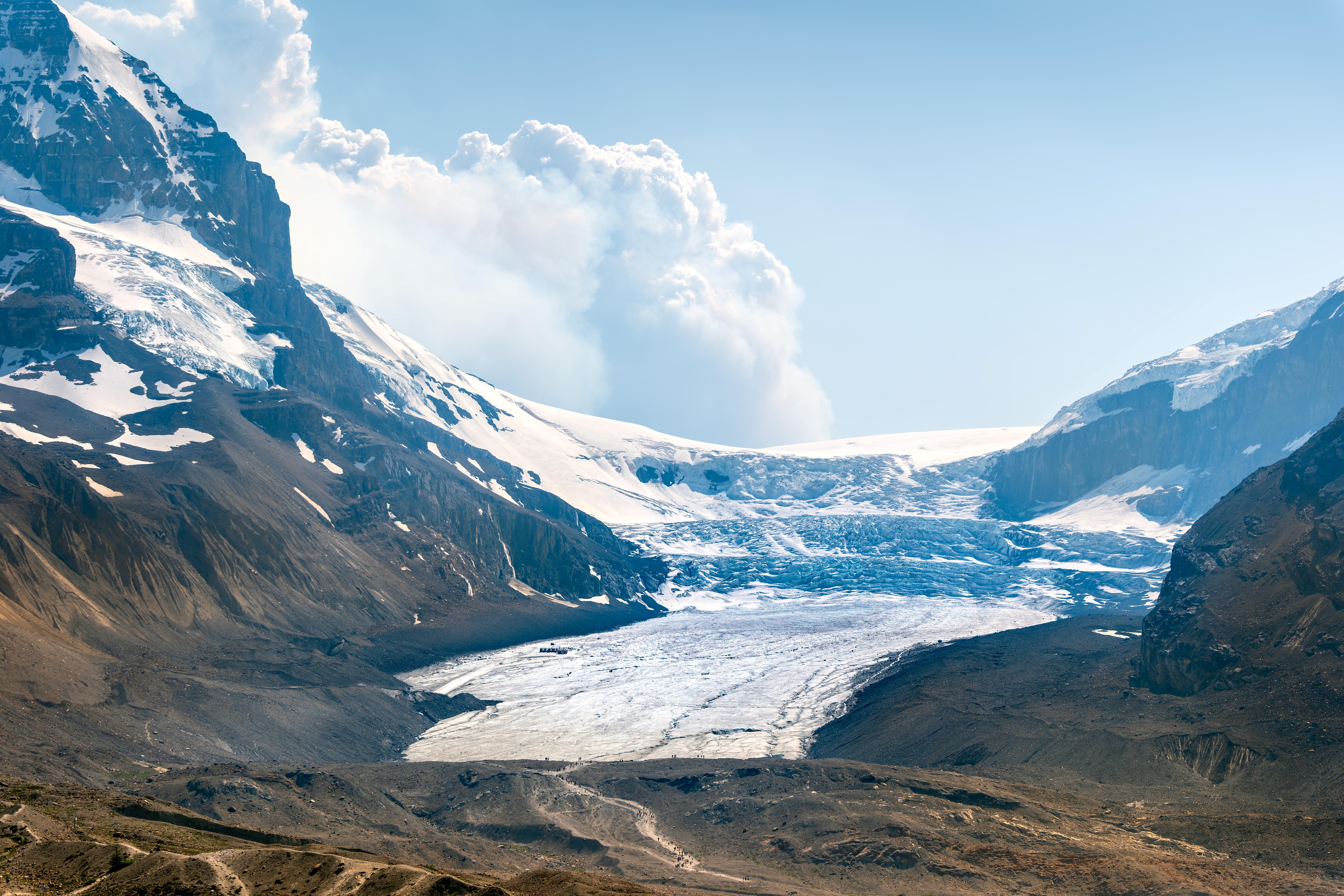
The Icefields Parkway is widely considered the finest mountain drive in North America and among the greatest scenic highways in the world. Highway 93 North sweeps 230 kilometers through the heart of the Canadian Rockies between Lake Louise and Jasper, climbing through two UNESCO World Heritage national parks along the spine of the Continental Divide. More than 100 glaciers are visible from the road, fed by immense icefields that straddle the peaks above. The parkway crests at Bow Summit (2,088 m), the highest point on any public road in the Canadian Rockies, where Peyto Lake fills a glacier-carved basin below in a shade of turquoise that seems impossible until you see it. Farther north, the Columbia Icefield, the largest body of ice in the Rocky Mountains at 325 square kilometers, spills glacial tongues down both sides of the Divide. The Athabasca Glacier, one of the few glaciers on Earth accessible by road, descends to within walking distance of the highway. Between the icefields, the road threads through the Mistaya and Athabasca valleys past waterfalls, canyons, and wildlife: elk, bighorn sheep, mountain goats, black bears, grizzlies, and, if you are extraordinarily fortunate, the endangered woodland caribou that still roam the southern Jasper herds in numbers now counted in the dozens. The road was built during the Depression as a public works project and opened in 1940. There are only two places to refuel along the entire 230 kilometers.


Key Stops

Lake Louise The starting point and one of the most photographed lakes in the world, cradled below Victoria Glacier at the base of the Continental Divide. The milky turquoise water gets its color from glacial flour suspended in meltwater. The Fairmont Chateau Lake Louise provides a grand backdrop. The Lake Agnes Teahouse hike (3.5 km one way) rewards with a rustic teahouse perched above a waterfall. Allow time here before starting the parkway.

Moraine Lake (Side Trip) Eight kilometers south of Lake Louise village, Moraine Lake sits in the Valley of the Ten Peaks, the view that appeared on the Canadian twenty-dollar bill in 1969 and 1979. Private vehicles are no longer permitted on Moraine Lake Road during peak season (June through mid-October). Access is by Parks Canada shuttle from the Lake Louise Park and Ride (reservations required through reservation.pc.gc.ca) or licensed tour operators. Reservations sell out within minutes of opening, typically in April. Plan ahead.

Herbert Lake The first stop on the parkway, a mirror-still lake reflecting the surrounding peaks on calm mornings. A pulloff and picnic area sit among lodgepole pines. Hardy locals swim here in summer.

Hector Lake Viewpoint About 13 kilometers north, a designated viewpoint reveals Hector Lake, the largest natural lake in Banff National Park, fed by the Waputik Icefield. Avalanche paths tumble down the Waputik Mountains to the west.

Bow Lake One of the most beautiful lakes on the parkway, with the red-roofed Num-Ti-Jah Lodge on its shoreline. Bow Lake is fed by Bow Glacier, one of eight glaciers descending from the Waputik Icefield. A 9-kilometer trail leads to Bow Glacier Falls. The lake is the source of the Bow River, which flows through Banff, Calgary, and across the prairies.

Peyto Lake (Bow Summit) The highest point on the parkway at 2,088 meters. A short paved trail from the parking area leads to viewing platforms above Peyto Lake, whose creamy blue-green water, shaped like a wolf's head, fills a glacial basin below. The color comes from glacial flour flowing from the Wapta Icefield. Parking is limited and first-come, first-served; the lot fills between 10 a.m. and 4 p.m. in July and August. Arrive early or late.

Mistaya Canyon Just past Waterfowl Lakes Campground, a short walk along an old logging road leads to a bridge spanning the rushing Mistaya River as it carves deep, swirling potholes through a narrow limestone gorge. The carved rock forms are among the most photogenic geological features on the parkway.

Saskatchewan River Crossing The only mid-route services: fuel, food, and lodging where the North Saskatchewan, Mistaya, and Howse rivers converge. The name dates to 19th-century fur traders. Open approximately mid-April through mid-October. This is the only fuel between Lake Louise and Jasper. Fill up.

Weeping Wall The steep cliff face of Cirrus Mountain weeps with streams of meltwater in spring and summer, building a thick wall of ice in winter that attracts ice climbers from around the world.

Big Bend A dramatic hairpin turn where the road rises sharply near the boundary of Jasper National Park. A turnout at the steepest section overlooks the horseshoe-shaped North Saskatchewan Valley below.

Parker Ridge A steep 2.5-kilometer trail (275 m elevation gain) through subalpine fir and Engelmann spruce to an unforgettable view of the Saskatchewan Glacier, the longest glacier in the Columbia Icefield. Above the tree line, wildflowers (moss campion, rock jasmine, forget-me-nots) bloom in the brief alpine summer. One of the finest short hikes in the Canadian Rockies.

Columbia Icefield and Athabasca Glacier The drive's centerpiece: the largest body of ice in the Rocky Mountains, covering 325 square kilometers with ice up to 365 meters deep. The Athabasca Glacier descends from the icefield to within walking distance of the highway; recession markers along the access trail show the glacier's retreat (roughly 5 meters per year). The Columbia Icefield Discovery Centre offers exhibits, dining, and departure points for the Ice Explorer snow coach tours onto the glacier surface (approximately $110–$125 per adult) and the Columbia Icefield Skywalk, a glass-floored observation platform extending over the Sunwapta Valley (combo tickets approximately $115–$125 per adult). Book in advance through Pursuit (banffjaspercollection.com). Open approximately late April through mid-October.

Sunwapta Falls The Sunwapta River ("turbulent river" in Stoney Nakoda) changes course violently here, crashing through a gorge in a display of raw power. Viewpoints above and below the falls are reached by short trails from the parking area.

Kerkeslin Goat Lick Mountain goats descend from the red-rocked slopes of Mount Kerkeslin to graze on calcium-rich and sulfate-rich soil beside the highway. Best viewing at dawn and dusk in winter and spring, but sightings are possible year-round.

Athabasca Falls Only 23 meters high, but among the most powerful waterfalls in the Canadian Rockies. Meltwater from the Columbia Glacier feeds the Athabasca River, which carves deep, swirling potholes into soft limestone. A short trail leads to viewpoints below the falls. The surrounding canyon walls have been sculpted into extraordinary shapes by millennia of erosion.

Mount Edith Cavell (Side Trip) An 18-mile detour on Cavell Road (narrow, winding switchbacks; no trailers or RVs over 7 meters) leads to the base of the 3,363-meter peak. The short Path of the Glacier Trail passes a robin's-egg-blue lake with icebergs calved from Angel Glacier and Cavell Glacier. Cavell Meadows above bloom with wildflowers from mid-July through mid-August.

Jasper The "little town in the big park" at the parkway's northern terminus, home to fewer than 5,000 residents but hosting roughly 2 million visitors annually. The Jasper SkyTram (Canada's longest and highest aerial tramway) ascends Whistlers Mountain to 2,263 meters for panoramic views of six mountain ranges. The Maligne Lake Road (30 miles) is one of the best wildlife-viewing routes in the Rockies, passing Maligne Canyon and reaching Maligne Lake, where boat tours visit Spirit Island. Following the 2024 wildfire, accommodation capacity in Jasper is significantly reduced. Book well in advance and check jasper.travel for current rebuilding status.


Driving Tips

  • There are only two places to refuel on the entire 230-kilometer parkway: Saskatchewan River Crossing (mid-route, open approximately mid-April through mid-October) and Jasper. Fill your tank completely in Lake Louise before starting.
  • A Parks Canada entry pass is required. Daily passes are approximately $11 per adult, $22 per family/group. Youth 17 and under are free. The Discovery Pass ($75.25 per adult annually) covers all Canadian national parks. For summer 2026, the Canada Strong Pass offers free park admission from June 19 through September 7 (confirm at parks.canada.ca). The free pass does not cover commercial activities like the Ice Explorer, Skywalk, or campsite fees.
  • Cell coverage is virtually nonexistent along most of the parkway. Download offline maps and do not rely on phone navigation. Tell someone your itinerary before departing.
  • Wildlife is a genuine hazard. Elk, bighorn sheep, bears, and mountain goats are frequently on or beside the road. Maintain a speed well below the posted 90 km/h limit and never approach or feed wildlife. Parks Canada regulations require you to stay at least 100 meters from bears and wolves, 30 meters from all other wildlife.
  • The parkway is open year-round but is best driven June through September. Winter driving (November through April) requires winter tires (legally mandated), a full tank of fuel, emergency supplies, and experience on mountain roads. No services are available between Lake Louise and Jasper in winter. Avalanche control can close sections for hours without notice.
  • Book Moraine Lake shuttle reservations and Columbia Icefield tours well in advance, especially for July and August.
  • Arrive at Peyto Lake before 10 a.m. or after 4 p.m. to avoid the parking lot filling. The Bow Lake pulloff and Parker Ridge trailhead are less congested alternatives in peak hours.
  • The drive is best spread over two days with an overnight at Saskatchewan River Crossing (The Crossing Resort, seasonal), the Icefields Centre area, or a backcountry campsite. One day is possible but leaves no time for the hikes that make this route exceptional.
  • For more information visit: Parks Canada: Icefields Parkway

Waypoints (16)

☰
1
Lake Louise
⛰️ 2066 m
4 km
7m
☰
2
Herbert Lake
⛰️ 2085 m
22 km
17m
☰
3
Hector Lake Viewpoint
⛰️ 2187 m
22 km
18m
☰
4
Bow Lake
⛰️ 2326 m
0.59 km
2m
☰
5
Peyto Lake
⛰️ 2328 m
0.59 km
1m
☰
6
Mistaya Canyon
⛰️ 2026 m
36 km
27m
☰
7
Saskatchewan River Crossing
⛰️ 2007 m
28 km
20m
☰
8
Weeping Wall
⛰️ 2265 m
21 km
16m
☰
9
Big Bend
⛰️ 2343 m
49 km
35m
☰
10
Parker Ridge
⛰️ 2343 m
1 km
2m
☰
11
Columbia Icefield & Athabasca Glacier
⛰️ 2501 m
24 km
17m
☰
12
Sunwapta Falls
⛰️ 1925 m
0.19 km
0m
☰
13
Kerkeslin Goat Lick
⛰️ 1836 m
37 km
32m
☰
14
Athabasca Falls
⛰️ 1739 m
50 km
55m
☰
15
Jasper SkyTram
⛰️ 1598 m
0.23 km
1m
☰
16
Maligne Lake
⛰️ 2054 m