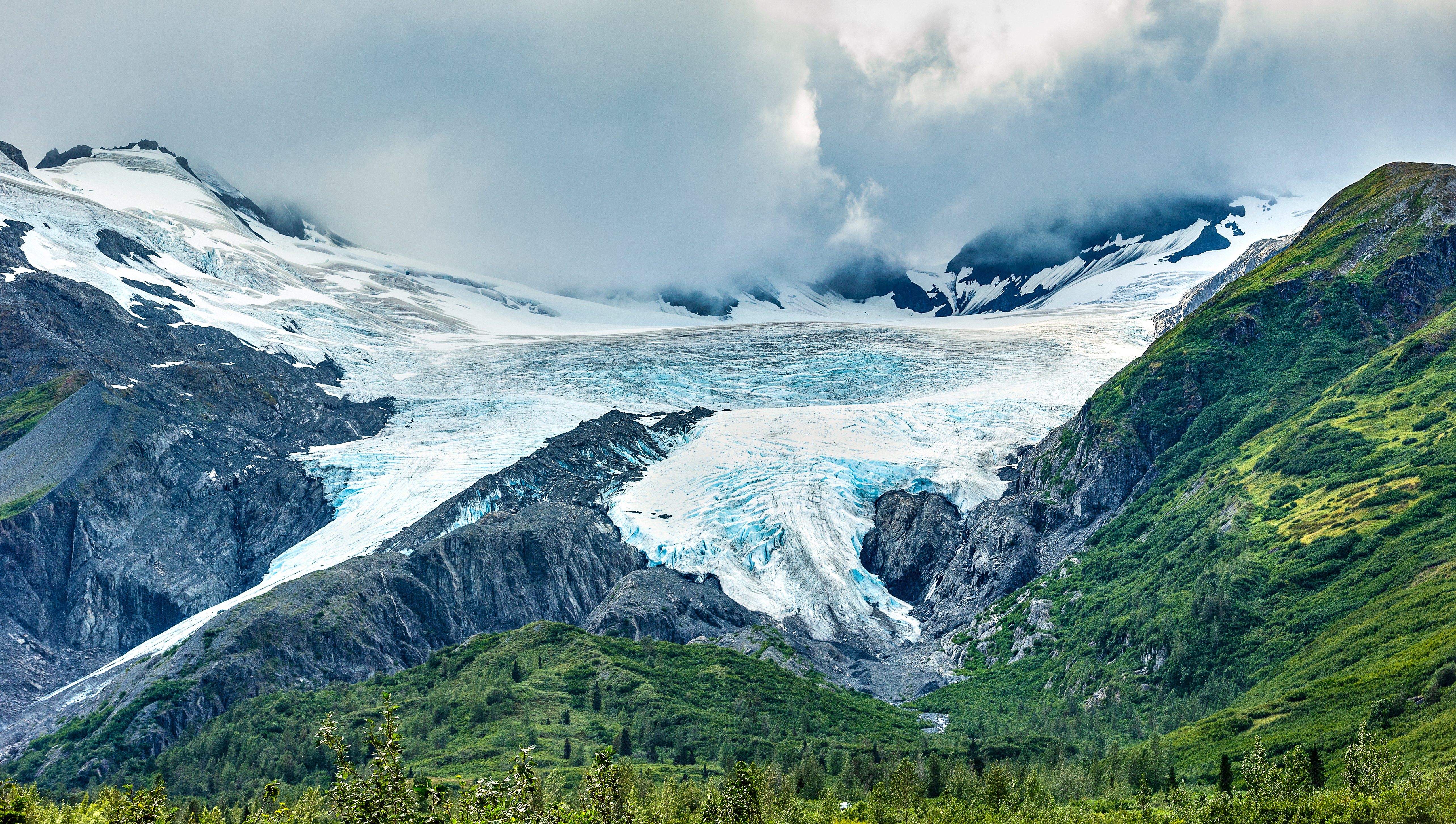
Glenn Highway

Alaska's Road to the Last Glacier You Can Drive To
The Glenn Highway leaves Anchorage heading northeast through the glacier-gouged Matanuska Valley, crosses two alpine passes, and ends at Glennallen on the edge of the Copper River Basin, where the Wrangell Mountains fill the southeastern horizon. The road follows the braided Matanuska River for much of its length, passing through a landscape carved by ice 12,000 years ago and still being shaped by it today: at Mile 102, the Matanuska Glacier, 27 miles long and 4 miles wide, is the largest glacier in the United States accessible by car. Beyond the glacier, the highway climbs through copper-colored mountains where Dall sheep graze on gypsum-rich slopes visible without binoculars, crests Eureka Summit at 3,322 feet with views of four mountain ranges simultaneously, and descends through "drunken forest" (black spruce tilting at crazy angles in permafrost) into the interior. Named for Captain Edwin Forbes Glenn, who led military expeditions through this country in 1898 searching for a route to the Klondike gold fields, the highway was completed during World War II and paved in the 1950s. It remains one of the great wilderness drives in North America.
Key Stops
Eklutna Historical Park Twenty-six miles from Anchorage, Eklutna is a Dena'ina Athabascan settlement dating to approximately 1650. Guided tours take in the St. Nicholas Russian Orthodox Church and a cemetery of brightly painted Spirit Houses, small wooden structures placed over graves reflecting a blend of Dena'ina traditions and Russian Orthodox Christianity. Each Spirit House is hand-built and painted in the colors of the deceased's family. Nearby, Eklutna Lake (known as Idlu Bena in Dena'ina) offers kayaking, hiking, and camping in a valley framed by the Chugach Mountains.
Palmer A farming town in the heart of the Matanuska Valley, established in 1935 when 203 families from Depression-ravaged farms in Minnesota, Michigan, and Wisconsin were relocated here as part of a New Deal agricultural colony, believed to be the first and only one of its kind in America. The rich glacial soil and summer daylight stretching past 19 hours produce world-record vegetables: cabbages weighing up to 90 pounds, radishes the size of softballs. The Alaska State Fair, held during the 10 days before Labor Day, displays the results. The Musk Ox Farm at Mile 50 offers tours of these arctic herbivores, whose underwool (qiviut) is said to be eight times warmer than sheep's wool by weight. Nearby, the Palmer Hay Flats feature a "Ghost Forest" of dead trees, their roots drowned when the 1964 Great Alaska Earthquake dropped the land below water level.
Matanuska River Valley From Palmer, the highway follows the wide curves of the Matanuska River through a valley carved between the Chugach Mountains to the south and the Talkeetna Mountains to the north. The braided river channels, fed by glacial meltwater, carry silver-gray, silt-laden water across broad gravel beds. Pullouts along this stretch offer views of snow-capped peaks and the river corridor that narrows as the road climbs toward the glacier.
Long Lake At approximately Mile 85, Long Lake stretches alongside the highway, stocked with rainbow trout and Arctic char. The Long Lake State Recreation Site has a boat launch and parking. The surrounding mountains close in here, and the landscape begins its transition from valley floor to alpine terrain.
Matanuska Glacier The centerpiece of the drive. At 27 miles long and 4 miles wide, the Matanuska Glacier is the largest glacier accessible by car in the United States. At Mile 101, the Matanuska Glacier State Recreation Site offers a free public viewpoint with parking, restrooms, and telescopes (USD 5 day-use fee). Walk-on access to the glacier itself is at Mile 102 through the Glacier Park Resort on private land: visitors sign a waiver, receive helmets and crampons, and walk with a guide onto the ice. Guided glacier tours depart daily (approximately USD 55 to 65 per adult, 2 to 3 hours). Ice climbing trips are available through NOVA Alaska Guides and MICA Guides. The Mile 103.3 scenic turnout provides the closest roadside view. Most glaciers of comparable size require helicopter or boat access; the Matanuska is extraordinary because you can drive to it and stand on it.
Sheep Mountain At Mile 113, the copper-colored slopes of Sheep Mountain (6,223 feet) concentrate one of the most visible populations of Dall sheep in Alaska. The south-facing gypsum-rich slopes attract the sheep for their mineral content, and they are often visible from the road without binoculars, especially from late May (when lambs appear) through mid-September. Sheep Mountain Lodge offers food, lodging, and 360-degree mountain views.
Eureka Summit The highest point on the Glenn Highway at 3,322 feet (Mile 129). The view from the summit is one of Alaska's great panoramas: four major mountain ranges are visible simultaneously: the Alaska Range to the northwest, the Chugach Mountains to the south, the Talkeetna Mountains to the west, and the Wrangell-St. Elias Mountains to the southeast. The open tundra country on either side of the summit (Mile 120 to 140) is habitat for the Nelchina caribou herd, the third-largest in Alaska. Sightings are most likely in July and August. In late August and September, the tundra and alpine blueberry bushes turn crimson and gold.
Lake Louise Turnoff At Mile 160, a 19-mile detour leads to Lake Louise, known as Sasnuu' Bena in the Ahtna Athabascan language. The lake offers fishing for lake trout, burbot, and Arctic grayling. Historic cabins, including an Eisenhower-era lodge, line the shore.
Glennallen The eastern terminus, at the junction with the Richardson Highway. The town is named for Captain Edwin Glenn and Lieutenant Henry Allen, two early explorers of the region. Glennallen is the gateway to Wrangell-St. Elias National Park and Preserve, the largest national park in the United States (six times the size of Yellowstone, with nine of the sixteen highest peaks in North America). Fuel, groceries, and tour services are available. From here, the Richardson Highway runs south to Valdez and north to Fairbanks; Alaska Route 1 continues northeast as the Tok Cutoff (125 miles to Tok and the Alaska Highway), passing through Mentasta Pass with increasingly dramatic views of the Wrangell Mountains.
Driving Tips
- Fuel: Fill up in Palmer. The next reliable fuel is in Glennallen, roughly 140 miles away. Sheep Mountain Lodge and isolated roadhouses may have limited fuel, but do not count on them.
- Frost heaves: Watch for rough road sections, particularly around Mile 116, marked by fluorescent orange "rough road" signs. Freeze-thaw cycles buckle the pavement. Slow down in these areas.
- Wildlife on the road: Moose are common throughout the route, particularly in river valleys near Palmer. They are a serious collision hazard, especially at dawn and dusk. Carry bear spray if you plan to hike at any stop.
- Matanuska Glacier access: Walk-on access is through private land at Mile 102 only. You must sign a waiver and pay a fee. The state recreation site at Mile 101 offers views but not glacier access. Guided tours are required.
- Dall sheep viewing: Sheep Mountain (Mile 113) is the prime spot. Pull over safely at designated viewpoints. Do not stop in the travel lane or approach the sheep.
- Winter driving: The highway is open year-round but demands winter preparedness: snow tires or chains, emergency supplies, extra food, water, warm clothing, and a full tank. Check conditions at 511.alaska.gov. Eureka Summit receives heavy snowfall with reduced visibility. Avalanche risk exists.
- Daylight: At the summer solstice, this latitude receives over 19 hours of daylight with extended twilight. At the winter solstice, only 5 to 6 hours. Plan accordingly.
- Mosquitoes: Voracious at lower elevations from June through August. Bring repellent and head nets if hiking.
- Cell coverage: Limited or nonexistent outside of Anchorage, Palmer, and Glennallen. Download offline maps before departure.
- RVs: The route is RV-accessible, but some curves and climbs can be challenging for large rigs. Campgrounds are available at King Mountain, the Matanuska Glacier State Recreation Site, and the Tahneta Pass area.
- For more information visit: Travel Alaska