RoadDrive
AboutApp StoreSign In / Up

Dead Horse Point & Island in the Sky

Dead Horse Point & Island in the Sky
Dead Horse Point State Park
Upheaval Dome
United States
99 km
1h 54m

Standing on the Edge of Deep Time

Highway 313 climbs from the desert floor west of Moab onto a high mesa that juts like a peninsula between the Colorado and Green Rivers, 2,000 feet above their confluent canyons. The road splits at the mesa's spine — one fork leading to Dead Horse Point State Park, the other into Canyonlands' Island in the Sky district — and both end at overlooks so vast they strain the eye's ability to process depth. Explorer John Wesley Powell described Canyonlands as "a wilderness of rocks…with ten thousand strangely carved forms in every direction," and from these mesa-top perches the description feels like understatement. The landscape unfolds in visible layers of geologic time: 300-million-year-old White Rim sandstone forms a broad bench below, while the rivers have cut another 1,000 feet deeper into even older rock. Unlike neighboring Arches, which draws millions, Island in the Sky remains the least visited of Utah's Mighty Five parks — offering the same caliber of scenery with a fraction of the crowds. Both parks hold Gold-Tier International Dark Sky designations, making the mesa one of the finest stargazing corridors in the Western Hemisphere.


Key Stops

The Neck About 18 miles up Highway 313, the road crosses a narrow land bridge of rock only 30 yards wide, with sheer cliffs dropping away on both sides. This natural bottleneck creates the "island" effect — everything south of The Neck is a flat-topped mesa surrounded by 2,000-foot walls. In the 1800s, cowboys used The Neck as a natural gate, fencing it with juniper branches to corral wild mustangs on the point beyond. The road fork to Dead Horse Point and Island in the Sky lies just ahead.

Dead Horse Point State Park The overlook towers 2,000 feet above a dramatic gooseneck bend in the Colorado River, with Canyonlands' pinnacles and buttes stretching to the horizon — a view so cinematic it served as the backdrop for the final scene of Thelma & Louise. The point gets its name from a grim legend: in the 1800s, cowboys left unwanted horses corralled on this waterless promontory, where the animals died of thirst within sight of the river far below. Eight scenic overlooks line the East and West Rim trails (8 miles of easy hiking), and the Intrepid Trail System offers 17 miles of mountain biking. Dead Horse Point was Utah's first state park certified as an International Dark Sky Park (2016). Entry is $20 per vehicle; camping is available in Kayenta and Wingate campgrounds with electric hookups and yurts ($100–$150/night).

Shafer Canyon Overlook (Island in the Sky) The first viewpoint after the Island in the Sky Visitor Center, a 0.3-mile walk leads to the canyon rim where you can peer directly down at the Shafer Trail Road — a series of dramatic switchbacks carved into the cliff face, descending from the mesa top to the valley floor. The unpaved road requires high-clearance 4WD and is impassable when wet, but even from above the engineering is mesmerizing. This is also the starting descent for the famous White Rim Road.

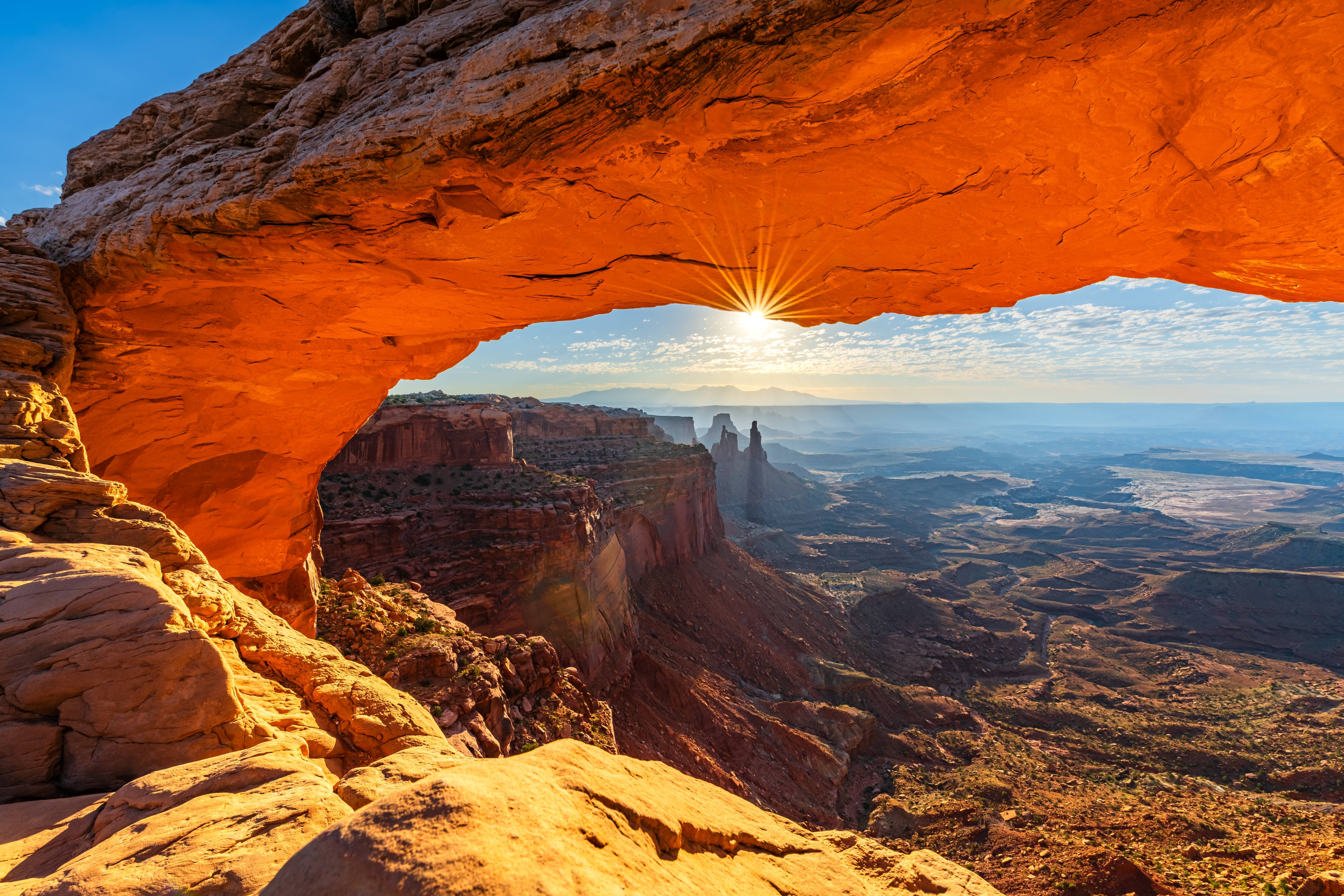
Mesa Arch The most photographed sunrise in Utah. A short, easy trail (less than half a mile) leads to a slender arch perched on the very edge of a 500-foot cliff. At sunrise, light bouncing off the canyon floor below illuminates the underside of the arch in a vivid orange glow, framing the La Sal Mountains and Washerwoman Arch in the distance. Expect 50 or more photographers with tripods during peak season — arrive 30 to 45 minutes before sunrise. The parking lot holds only 25 cars.

Buck Canyon Overlook Between Mesa Arch and Grand Viewpoint, this east-facing overlook is the only viewpoint along the drive that offers a straight-on canyon view. A short paved walkway leads to a railed platform with a nearly 180-degree panorama into the deep reds and whites of Buck Canyon's layered walls. It's a quieter stop that most visitors drive past, and all the better for it.

Grand View Point Overlook The road's terminus and the climax of the drive. A paved wheelchair-accessible path leads to the main overlook at 6,080 feet, where the mesa drops away into a basin of towers, buttes, and canyons that extend 100 miles to the horizon. Monument Basin's slender spires rise from the canyon floor below, the White Rim Road traces a pale bench in the middle distance, and on clear days you can see the La Sal Mountains, the Abajo Mountains, and the distant features of both The Maze and The Needles districts. A 1.8-mile trail follows the mesa rim for even more expansive views. This is as close to standing on the edge of the Earth as most people will ever get.

Green River Overlook A short spur road past Willow Flat Campground ends at this southwest-facing viewpoint, 1,300 feet above the Green River's emerald ribbon winding through Wingate sandstone walls. The Green joins the Colorado 20 miles downstream at the Confluence — the geographic heart of Canyonlands. This is the premier sunset viewpoint in the district, and the wide-open western horizon makes it ideal for watching the canyon walls shift through gold, orange, and deep purple.

Upheaval Dome A 5-mile spur road off the main scenic drive leads to this geological puzzle — a three-mile-wide crater-like structure that for decades split geologists between meteorite impact and collapsed salt dome theories. In 2007, researchers found shocked quartz crystals, essentially settling the debate in favor of a meteorite impact roughly 60 million years ago. Two overlook trails (the first at 0.8 miles, the second at 1.8 miles round trip) provide views into the dome's concentric rings of upturned rock.

White Rim Road (for the adventurous) Visible from nearly every overlook, this 100-mile unpaved loop traces the White Rim sandstone bench 1,200 feet below the mesa top. It requires a high-clearance 4WD vehicle (10-foot height limit due to rock overhangs), a permit from Recreation.gov, and 2–3 days for the full loop. Mountain bikers typically take 3–4 days. Day-use permits can be reserved up to 24 hours in advance; overnight permits close 3 days prior. It is one of the great backcountry drives in the American West.


Driving Tips

  • Two parks, two fees: Dead Horse Point State Park ($20/vehicle) and Canyonlands ($30/vehicle) charge separate entrance fees. The America the Beautiful Pass covers Canyonlands but not the state park; a Utah State Parks annual pass covers Dead Horse Point.
  • Start early: For Mesa Arch at sunrise, arrive 30–45 minutes before dawn — the 25-space parking lot fills fast in spring and fall. An early start also means cooler temperatures and fewer crowds at every overlook.
  • Fuel and water: No gas, food, or water is available on Highway 313, at Dead Horse Point, or inside Island in the Sky. Fill up in Moab. The Island in the Sky Visitor Center has drinking water spring through fall only.
  • EV charging: No chargers at either park. Moab has Tesla Superchargers and Level 2 stations — charge fully before heading up Highway 313 (the round trip is 65+ miles).
  • Cell service: Some coverage on the mesa top near the visitor center and overlooks (Verizon best), but unreliable. No service in canyons or backcountry. Download offline maps.
  • Heat: Summer temperatures exceed 100°F on the exposed mesa with no shade at overlooks or on most trails. Carry at least one liter of water per person per hour of hiking.
  • Shafer Trail and White Rim: 4WD only, impassable when wet. Check NPS road conditions before attempting. ATVs, UTVs, and OHVs are not permitted.
  • Dark skies: Both parks are International Dark Sky Parks. Moonless nights reveal the Milky Way in extraordinary detail — consider timing your visit around the new moon.
  • Crowds: Island in the Sky is significantly less crowded than Arches, especially midweek. No timed entry is required.
  • For more information visit: Canyonlands National Park (NPS)

Waypoints (10)

☰
1
Dead Horse Point State Park Visitor Center
⛰️ 1614 m
2 km
3m
☰
2
The Neck
⛰️ 1614 m
13 km
14m
☰
3
Dead Horse Point
⛰️ 1614 m
12 km
11m
☰
4
Shafer Canyon Overlook
⛰️ 1545 m
14 km
16m
☰
5
Mesa Arch
⛰️ 1735 m
0.37 km
1m
☰
6
Buck Canyon Overlook
⛰️ 1675 m
8 km
9m
☰
7
Grand View Point Overlook
⛰️ 1632 m
3 km
3m
☰
8
Green River Overlook
⛰️ 1704 m
27 km
31m
☰
9
Upheaval Dome
⛰️ 1550 m
20 km
21m
☰
10
White Rim Road - Start
⛰️ 1755 m