Bolivia's Death Road
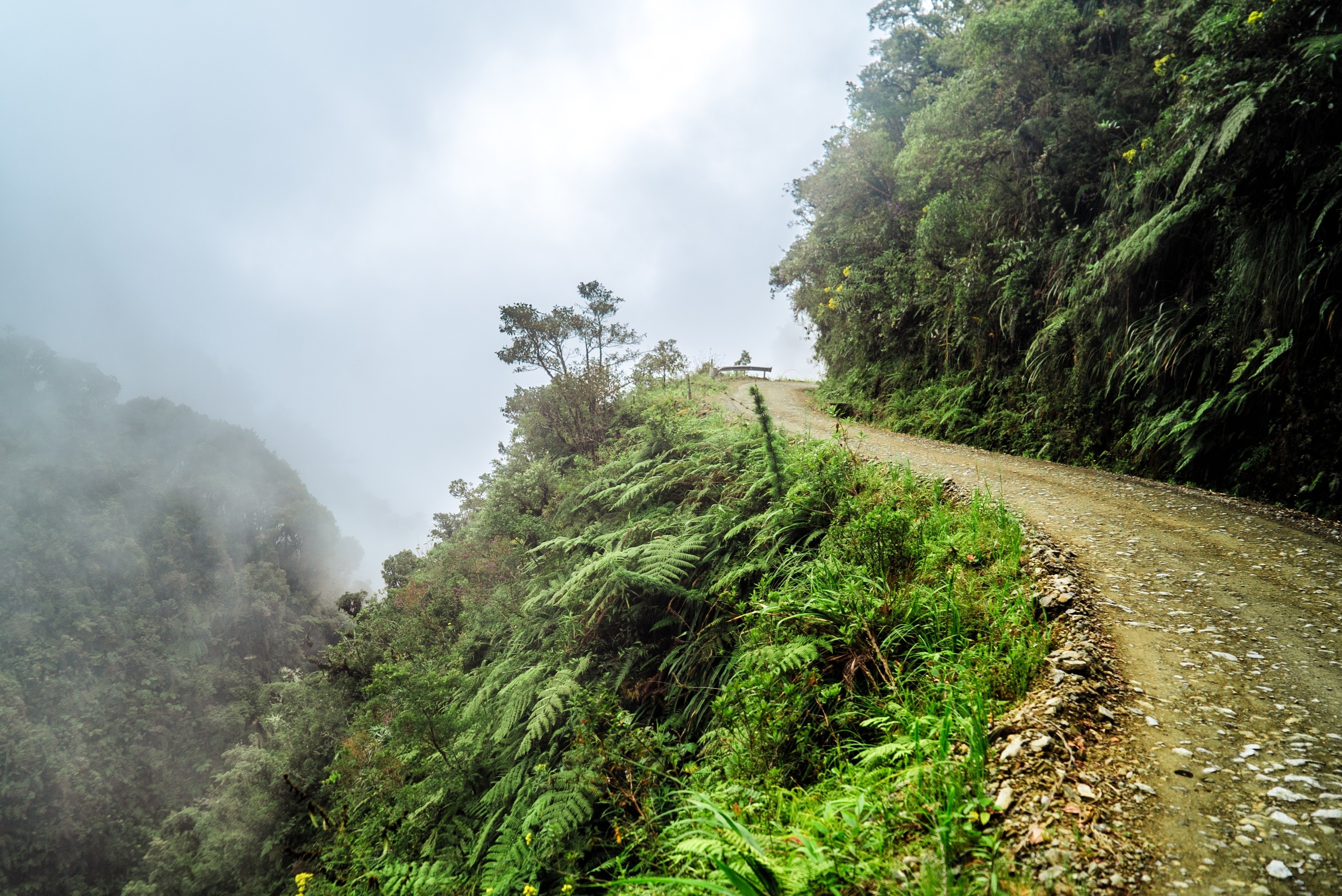
The Most Dangerous Road on Earth
El Camino de la Muerte, the Road of Death, is the most infamous road on Earth. Carved into the sheer face of an Andean mega-canyon in the 1930s by Paraguayan prisoners of war captured during the Chaco War (1932-1935), this impossibly narrow dirt track clings to a mountainside where 1,000-metre vertical drops yawn inches from your tyres, waterfalls cascade directly onto the roadway, and fog can erase the world beyond your bonnet without warning. For decades it was the only route connecting La Paz with Bolivia's Amazon lowlands, and the statistics were horrifying — 200 to 300 vehicles plunged off the edge each year, earning it the Inter-American Development Bank's designation as "the world's most dangerous road" in 1995.
Today, a modern bypass highway (Route 3) completed in 2006 carries virtually all commercial traffic through tunnels and over bridges on a safe, paved two-lane road. The old Death Road is now largely closed to through traffic and has been reborn as one of the planet's most extraordinary adventure tourism destinations — primarily for mountain biking, but still drivable by car on the original track. The journey descends from the frozen, wind-blasted heights of La Cumbre Pass at 4,650 metres through misty cloud forest and into the warm, humid subtropical jungle of the Yungas — a complete transformation of climate, vegetation, and altitude compressed into just 64 kilometres.
Key Stops
La Paz - The starting point and the world's highest capital city at 3,660 metres. The chaotic, sprawling city fills a dramatic bowl carved into the altiplano, with snow-capped Illimani (6,438 m) towering above. Before departing, visit the Witches' Market, ride the Mi Teleférico cable car system for aerial city views, and acclimatise to the altitude for at least a full day. Stock up on supplies — there is nothing on the road ahead.
La Cumbre Pass (4,650 m) - The highest point of the journey and the true beginning. This wind-swept Andean pass offers staggering panoramic views of snow-covered peaks, including Huayna Potosí (6,088 m). A stone monument marks the spot. The air is thin and biting cold. From here, the only direction is down — 3,500 vertical metres of it.
Chusquipata Junction - About 20 km from La Cumbre, the modern bypass and the old Death Road diverge. This is the decision point: left onto the new highway for safety, right onto the original dirt track for the experience. A small settlement with basic refreshments marks the fork.
The Death Road Proper (32 km) - The heart of the drive. From Chusquipata, the original road narrows to as little as 3 metres wide, with no guardrails, no pavement, and no margin for error. The cliff face rises vertically on one side; a sheer drop of up to 1,000 metres falls away on the other. Key features along the descent:
- The Crosses and Memorials - White crosses, shrines, and flower offerings mark spots where vehicles went over the edge. They appear with sobering frequency, each one a reminder of why this road earned its name.
- The Waterfalls - Multiple cascades pour directly across the road surface, drenching vehicles in impressive showers. In places, the road passes behind curtains of falling water. The rock above drips constantly, keeping the surface perpetually wet and muddy.
- The Switchbacks - Blind hairpin turns where the road is barely wide enough for a single vehicle. Approaching traffic is invisible around the rock wall until the last moment.
- The Cloud Forest Transition - As you descend below 3,000 metres, the barren Andean highlands give way to mist-shrouded cloud forest. Moss, ferns, orchids, and bromeliads drape from every surface. The air thickens, warms, and fills with humidity. The transformation is dramatic and beautiful.
- The Narrowest Points - Several sections contract to barely 3 metres with overhanging rock on one side and a vertical abyss on the other. Vehicles must fold in mirrors. Meeting oncoming traffic here requires one vehicle to reverse to a wider point.
Yolosa - The small village at the bottom of the Death Road where the old route meets the modern highway. This is where relief washes over you. Basic services, cold drinks, and the feeling of solid, level ground beneath your wheels.
La Senda Verde Wildlife Sanctuary - Just below Yolosa, this refuge houses over 600 rescued animals — monkeys, macaws, spectacled bears, ocelots, and more — in a lush jungle setting. A welcome decompression stop with a buffet lunch available. The surrounding Yungas vegetation is magnificent.
Coroico - The endpoint and reward. This charming hillside town at 1,200 metres sits in the subtropical Yungas, surrounded by coca plantations, coffee farms, and dense jungle. Hotels with swimming pools, restaurants serving fresh tropical cuisine, and panoramic views over green valleys make it an ideal place to spend a night recovering from the drive. Nearby attractions include:
- El Velo de la Novia - A beautiful waterfall in the surrounding hills
- Pozas del Vagante - Natural swimming pools in a jungle setting
- Tocaña Community - An Afro-Bolivian village known for its coffee production and Saya dance tradition
- Zip-line canopy tours - Several operators offer flights over the jungle canopy
Driving Tips
- Drive on the LEFT: This is the single most critical rule. Unlike the rest of Bolivia (which drives on the right), the Death Road requires left-hand driving. This positions the downhill driver on the cliff edge for a better view of the road's outer limit. This rule has saved countless lives.
- Downhill yields to uphill: Descending vehicles must always give way and move to the outer (cliff) edge to let ascending vehicles pass on the inside (mountain) wall. This is non-negotiable. The uphill vehicle has right of way because reversing uphill is far more dangerous.
- Low gear, always: Drive in first or second gear for the entire descent. The grade is relentless and your brakes will overheat if relied upon alone. Engine braking is your primary speed control.
- Speed: Crawl. 10-20 km/h is appropriate for most of the road. Faster is reckless. The entire 32 km descent takes 2-3 hours by car — and that is the correct pace.
- Vehicle choice: A 4x4 with high clearance is essential. The road surface is loose gravel, mud, and rock. Some sections are rutted or partially collapsed. Check brakes, tyres, and steering before departing.
- Dry season (May-October): The only sensible time to drive the old road. In the wet season (November-April), landslides, flooding, and reduced visibility make the already lethal road exponentially more dangerous. Some sections may be impassable.
- Fog and rain: Even in dry season, cloud and mist can roll in instantly at mid-altitudes. Visibility can drop to a few metres without warning. When this happens, stop and wait rather than push through blind.
- Waterfalls on the road: Drive through slowly and steadily. Do not brake suddenly on the wet surface. Waterfall sections are slippery — maintain momentum but keep speed minimal..
- No overtaking: Never attempt to pass another vehicle on the Death Road. Period.
- Altitude sickness: You begin at 4,650 metres. Headache, nausea, and impaired judgement are real risks if you haven't acclimatised. Spend at least 1-2 days in La Paz before attempting the drive. Coca tea helps.
- For more information visit: gravitybolivia.com