Big Sur Coast
Cliffs, Bridges and the Endless Pacific
California's Route 1 clings to the western edge of the continent where the Santa Lucia Mountains plunge into the Pacific — 90 miles of fabled coastline road built over 18 years by convict crews and Depression-era labourers, opened in 1937, and fully reopened on 14 January 2026 after three years of landslide closures. Driving south from Monterey, the highway leaps across the iconic Bixby Creek Bridge 260 feet above a gorge, climbs 1,000 feet above the sea through coast redwood groves, passes the purple sands of Pfeiffer Beach and the 80-foot McWay Falls tumbling onto an inaccessible turquoise cove, then runs wild and empty through lime kilns, jade coves, and cliff-edge viewpoints before delivering you to Hearst Castle, the elephant seal rookery at Piedras Blancas, and Morro Bay.
Key Stops
Monterey Once a lonely outpost under the Spanish crown — whose ships landed here in 1602 — Monterey was claimed for America in 1846 when the Stars and Stripes was raised at the Custom House. On the shore of the bay lies Cannery Row, the former sardine-processing hub where more than 30 canneries operated at their peak in the early 1940s. The sardine population collapsed in the postwar years, and the last cannery closed in 1973; the street was renamed in 1958 to honour John Steinbeck's 1945 novel. Today it houses restaurants, shops, and the world-class Monterey Bay Aquarium — built on the site of the old Hovden Cannery — whose latest centrepiece is Into the Deep, a $15 million, 10,000-square-foot exhibition developed with the Monterey Bay Aquarium Research Institute, featuring bloody-belly comb jellies, Japanese spider crabs with 10-foot leg spans, bubblegum corals, and species so new to science they remain unnamed. Aquarium tickets are $65 adult, online only. At 800 Cannery Row, the original Pacific Biological Laboratory — workplace of marine biologist Ed Ricketts, who inspired Steinbeck's character "Doc” still stands. On Fisherman's Wharf, seafood restaurants and whale-watching boats line the waterfront.
Pacific Grove Settled in 1875 by Methodist founders seeking a seaside retreat for religious contemplation. Follow Ocean View Boulevard along the bay to Lovers Point Park and the Point Pinos Lighthouse. Sunset Drive parallels the Pacific side to Asilomar State Beach, a wide swath of sand for strolling and soul-searching. Nicknamed "Butterfly Town USA," Pacific Grove is the winter home to monarch butterflies migrating from as far as Canada, congregating in dense clusters on eucalyptus and Monterey pine trees. The town imposes penalties on anyone who disturbs them.
17-Mile Drive A private toll road looping through the Monterey Peninsula past wind-gnarled Monterey cypresses, 1920s mansions, world-class golf courses — including Pebble Beach — and rocky Pacific headlands. Tour maps are provided at the five entrance tollgates. Exit at the Carmel gate to rejoin Route 1.
Carmel-by-the-Sea A one-square-mile artists' colony of fairy-tale cottages, galleries, sandy beaches, and a restored 18th-century Spanish mission. The town historically had no street addresses, no house numbers, no mail delivery, and no streetlights — all by design. Long a haven for poets, novelists, and painters. Clint Eastwood was elected mayor in 1986; among his first acts was overturning the ban on selling ice cream cones. He also purchased and restored the historic Mission Ranch, saving it from developers. The Mission San Carlos Borromeo (1770), founded by Father Junípero Serra, served as headquarters for the entire California mission chain and contains Serra's burial site — a National Historic Landmark and designated minor basilica. Follow Scenic Road along the Pacific to Carmel River State Beach.
Point Lobos State Natural Reserve Often called "the greatest meeting of land and water in the world." Trails wind along craggy fingers of rock capped with gnarled Monterey cypresses — one of only two naturally occurring stands remaining on Earth, survivors that retreated to these fog-shrouded headlands as the climate warmed at the close of the Pleistocene roughly 15,000 years ago. Sea lions bark from offshore islands. Sea otters loll belly-up in the kelp beds, cracking abalone shells with stones. Harbour seals haul out in sheltered coves. Gray whales pass offshore in winter and spring. More than 250 animal species have been recorded. The Cypress Grove Trail (0.8 miles, easy) and Sea Lion Point Trail (0.4 miles, paved) are the highlights. Entry $10 per vehicle. Arrive early — the reserve caps daily visitor numbers.
Garrapata State Park The name means "tick" in Spanish — check your clothing after walks — but the reward is four miles of diverse, pristine coastline: steep, rocky headlands in the north, sandy beaches in the south. No headquarters, no large car parks, just numbered gates marking trailheads along Route 1. Gates 13, 15, and 16 access Soberanes Point, a verdant ledge above the sea and one of the best spots on the drive to observe wild sea otters feeding in the kelp forests just offshore.
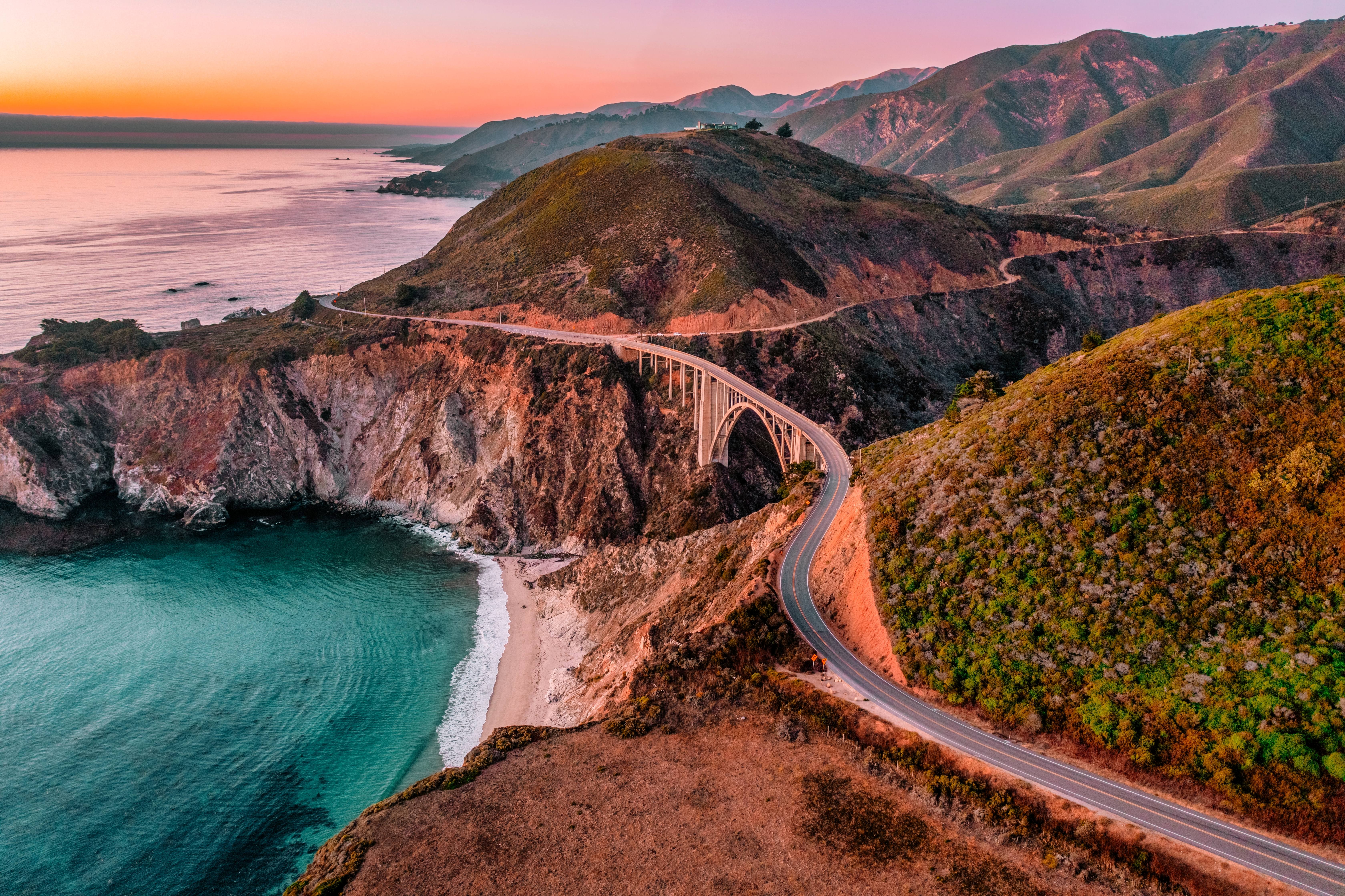
Bixby Creek Bridge The most photographed bridge in California, and one of the most recognised in the world. A reinforced concrete open-spandrel arch spanning 218 m, rising 260 feet above Bixby Creek where it empties into the Pacific. Construction began on 24 August 1931 and was completed 15 October 1932 — just 14 months — with 45,000 individual sacks of cement hauled up by cable slings suspended 300 feet above the creek. Total cost: $199,861. At completion, it was the highest single-span concrete arch bridge in the world. The best vantage point is the Castle Rock pullout on the north side — arrive before 9 AM, as the small pullouts fill fast.
Point Sur Light Station An 1889 lighthouse perched atop a massive dome-shaped volcanic rock 361 feet above the Pacific, its beam visible for more than 20 miles. Before its construction, shipwrecks were common on this treacherous point. The keepers and their families lived in near-total isolation. A horse trail was the only route down the coast before the highway was built, and supplies arrived by boat every four months. The old barn, blacksmith shop, and keeper's quarters still stand. Volunteer-led weekend tours tell their stories; between April and October, moonlight tours offer a haunting experience of the headland after dark.
Andrew Molera State Park A study in variety: wind-sheltered beaches, sea-cut cliffs, flower-filled meadows, free-flowing rivers, and a 3,450-foot mountain — all accessible only on foot. The primitive campsites let you fall asleep to the rhythmic rumble of the sea. This is prime habitat for the California condor — reintroduced to Big Sur by the Ventana Wildlife Society after the species was reduced to just 22 birds in 1987. The central California flock now numbers approximately 123 birds — the highest count in decades. Scan the ridgeline for their unmistakable silhouette and numbered wing tags. The Ventana Wildlife Society Discovery Center in Big Sur offers condor information, and guided condor-watching van tours ($50/person) run on the second Sunday of each month.
Pfeiffer Big Sur State Park The Big Sur River runs through 964 acres of forested park on the inland side of Route 1. The Pfeiffer Falls Trail — a 0.75-mile walk through a redwood gorge to a 60-foot waterfall — reopened in September 2025 after a two-year closure following storm damage. The trail is one of the park's biggest draws among its estimated 750,000 annual visitors. Further trails lead through a coast redwood grove — some trees 800 to 1,200 years old — to refreshing swimming pools edged with smooth boulders. The Buzzard's Roost Trail (4.8 miles round-trip) climbs to Pfeiffer Ridge with panoramic coastal views. Entry $10 per vehicle.
Pfeiffer Beach About a mile south, Sycamore Canyon Road exits Route 1 for one of Big Sur's hidden treasures — easy to miss, as the turnoff is unmarked. The beach is famous for its purple-tinted sand, coloured by manganese garnet particles washed down from the hillsides, most vivid after winter storms. Offshore, the dramatic Keyhole Rock has a natural arch carved through it; in December and January, the setting sun shines directly through the opening in a blaze of golden light. Patches of sand are wedged among rocks pitted with caves and blowholes carved by the sea's surge. Managed by the U.S. Forest Service, not State Parks — day-use fee $15 per vehicle (state park passes not accepted). Not suitable for RVs. The small car park fills early; arrive before 10 AM on weekends.
Nepenthe A restaurant and terrace perched 808 feet above the Pacific. In May 1944, Orson Welles and Rita Hayworth, travelling with actor Joseph Cotten, stopped to picnic, drove up an unmarked dirt road, discovered a 1925 cabin on a hill with sweeping south-coast views, and bought it that day for a cash down payment of $156. They divorced without ever returning. Bill and Lolly Fassett purchased the property in 1947 for $22,000 and hired Rowan Maiden, a student of Frank Lloyd Wright, to design the restaurant. Nepenthe opened in 1949 and has been family-operated ever since. The name comes from Homer's Odyssey — a potion used by the gods to induce forgetfulness of sorrow. The terrace delivers on the promise: miles-long views of the south coast, a California-Mediterranean menu, and the iconic Ambrosia Burger. Below, Café Kevah offers a more casual option with equally stunning views.
Henry Miller Memorial Library A bookshop, arts venue, and shrine to the American novelist who spent 18 years in Big Sur, writing about it in Big Sur and the Oranges of Hieronymus Bosch (1957). Founded by his friend Emil White, who built the house in the mid-1960s and dedicated it after Miller's death in 1980. It holds the second most extensive collection of Miller books, manuscripts, and letters in the world (after UCLA). It describes itself as "a place where nothing happens."
Julia Pfeiffer Burns State Park — McWay Falls After Route 1 descends from a climb that takes it nearly 1,000 feet above the sea, this park delivers Big Sur's most iconic image: McWay Falls, an 80-foot waterfall tumbling onto a pristine turquoise cove — one of only two tidefall waterfalls in California. The beach is inaccessible; you watch from above.
Limekiln State Park Set in the steepest coastal canyon in the continental United States, this 710-acre park hides a piece of industrial history in the redwood forest. The Limekiln Trail (0.5 miles, easy) crosses three scenic bridges over Limekiln Creek to reach four towering steel-and-stone kilns — remnants of the Rockland Lime and Lumber Company (1887–1890), which quarried limestone and smelted it to produce the powdered lime used in many buildings still standing in Monterey and San Francisco. A separate trail leads to the 100-foot, fan-shaped Limekiln Falls cascading down a limestone wall. The Hare Creek Trail passes through some of the largest redwood trees in Big Sur. Entry $10 per vehicle.
Nacimiento-Fergusson Road (side trip) A paved, 25-mile white-knuckle byway with hairpin curves and panoramic views that traverses the entire Santa Lucia Range from coast to interior — a dramatic detour for confident drivers seeking a taste of the rugged backcountry that few Big Sur visitors ever see.
Sand Dollar Beach & Jade Cove Sand Dollar Beach is the longest publicly accessible sandy beach along all 90 miles of the Big Sur coast — and one of the only places you can actually walk the shoreline. A wooden staircase switchbacks down the bluff to the sand; at low tide, a sea cave opens at the northern end and tide pools emerge at the south. Excellent for seaside picnics, with 14 shaded picnic sites on the bluff. Just beyond, Jade Cove holds the only concentrated underwater deposit of quality nephrite jade in the world. Take the short walk to the pebbled beaches hemmed by sea-carved cliffs and search for semi-precious fragments among the stones.
Ragged Point The southern gateway to Big Sur. The cliff-top inn offers the "Million Dollar View" — a sweeping panorama back along the entire wild coastline to the north. A short trail descends the cliff to a waterfall and black-sand beach below. This is where the dramatic Big Sur coast gives its final bow before the terrain transitions to the gentler rolling hills of San Luis Obispo County.
Piedras Blancas Elephant Seal Rookery One mile north of San Simeon, the largest mainland breeding colony of northern elephant seals, established in 1990 and now drawing over 25,000 seals annually across an 8-mile stretch of coastline. In January and February — peak birthing season — mothers deliver pups on the beach while massive bulls, weighing up to 2,300 kg, battle for dominance. February–March brings weaned pups learning to swim; April–May the moulting females; November the return of the adult males. A free boardwalk viewpoint puts you within metres of the colony. Volunteer docents from the Friends of the Elephant Seal are regularly present to answer questions. Free admission, open every day of the year.
Hearst Castle, San Simeon Officially Hearst San Simeon State Historic Monument — the hilltop palace of newspaper magnate William Randolph Hearst, designed by architect Julia Morgan (one of the first women licensed as an architect in California) and built between 1919 and 1947, never officially completed. The 165-room estate mixes classical and Mediterranean styles across a 127-acre property with striking views of Big Sur and the Pacific. Inside: 115 rooms in the main house (Casa Grande) plus three guesthouses, 58 bedrooms, 61 bathrooms, the Greco-Roman Neptune Pool, the gold-and-Venetian-glass-tiled Roman Pool, and over 20,000 art objects — Egyptian, Greek, and Roman antiquities, Old Master paintings, Renaissance ceilings from Italy and Spain. In the 1930s and 40s, floods of famous guests — Charlie Chaplin, Greta Garbo, Cary Grant, Clark Gable, Winston Churchill — were invited to the estate, inspiring the legend that partly fuelled Orson Welles' Citizen Kane. The Grand Rooms Tour ($35 adult, $18 children 5–12) covers the five principal rooms of Casa Grande and includes a film shown in Hearst's own theatre. Book via ReserveCalifornia.com up to 60 days in advance — tours sell out in peak season.
Cambria A charming village set among Monterey pines, six miles south of Hearst Castle. Once a dairy and mining town, Cambria now has a thriving arts and tourism economy. The East and West Villages along Main Street are lined with galleries, antique shops, boutiques, and restaurants. Moonstone Beach is famous for wave-worn moonstones and colourful jasper scattered across the sand; a one-mile ADA-accessible boardwalk runs along the bluff, excellent for spotting marine wildlife and shorebirds. The Fiscalini Ranch Preserve offers 430 acres of blufftop trails through Monterey pine forest.
Morro Bay Morro Rock, created by an ancient volcano, towers 575 feet above the Pacific at the harbour mouth, guarding a nearly landlocked bay of mud flats, tidal wetlands, and estuaries home to more than 250 bird species, including peregrine falcons nesting on the rock, black oystercatchers, and great blue herons. Morro Bay State Park has trails and a natural history museum. South of town, Montaña de Oro State Park turns gold when fields of mustard and poppies bloom across its slopes. The drive ends as Route 1 rejoins US 101 at San Luis Obispo, where Mission San Luis Obispo de Tolosa, founded by Junípero Serra in 1772, marks the finish — midway between San Francisco and Los Angeles.
Driving Tips
- Drive north to south. This places your vehicle on the ocean side with unobstructed views and easier access to pullouts.
- Fill your tank before entering Big Sur. In Monterey or Cambria.
- Start early. Popular pullouts (Bixby Bridge, Pfeiffer Beach, McWay area) fill by 9–10 AM on weekends and in summer.
- Use turnouts. California law requires slower vehicles to pull over when five or more cars are queuing behind. This is enforced on Highway 1.
- Check road conditions before departing. Rainstorms cause landslides; heavy rain makes the narrow road dangerous.
- Morning fogs are frequent in summer. Visibility can drop suddenly. Keep headlights on at all times.
- No cell service through most of Big Sur. Download offline maps and tell someone your plans and expected arrival time.
- Do not stop on the roadway for photos. Wait for a designated turnout. Stopping on blind curves is illegal and dangerous.
- Carry water, food, and warm layers. Services are sparse. Coastal fog can drop temperatures 10–15°C below nearby inland areas, even in midsummer.
- For more information visit: bigsurcalifornia.org