Beartooth Highway
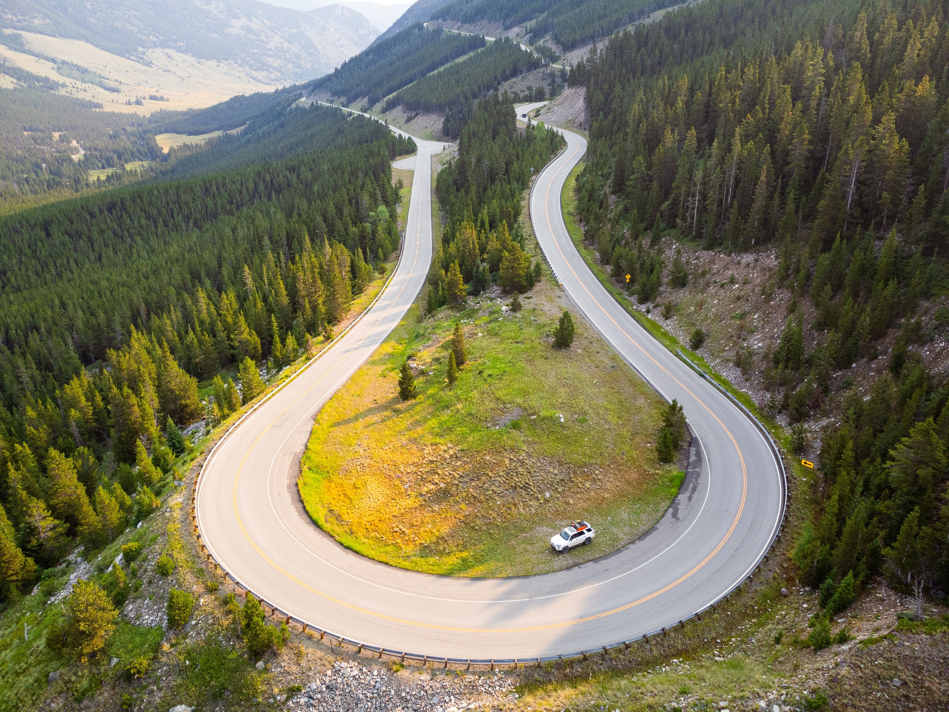
Where the Road Touches the Sky
Called "the most beautiful drive in America" by CBS newsman Charles Kuralt, the Beartooth Highway climbs nearly 1,650 m in its first 19 km through a series of dramatic switchbacks out of Rock Creek Canyon, then crosses a vast alpine tundra plateau above the treeline before cresting Beartooth Pass at 3,337 m — one of the highest paved roads in the United States. Opened on 14 June 1936 after five years of Depression-era construction that cost $2.5 million and two workers' lives, this All-American Road traverses some of the oldest exposed rock on Earth (2.7–4 billion years), passes hundreds of glacial lakes glinting across the plateau, and descends through wildflower meadows and forests of whitebark pine toward the old mining settlements of Cooke City and Silver Gate — gateway to Yellowstone National Park's least-trafficked entrance and the wolf- and grizzly-rich Lamar Valley.
Key Stops
Red Lodge A former coal-mining town (established 1884) at 1,695 m, where diverse immigrant communities from Finland, Italy, Norway, and Austria once worked the Rocky Fork mines. Today its historic commercial district offers self-guided walking tours past mining-era facades, while Red Lodge Mountain ski area provides 2,400 vertical feet of skiing across 1,635 acres. The Home of Champions Rodeo (July 2–4) draws 400+ top athletes with a $30,000 purse, and the eight-day Festival of Nations each August celebrates the heritage of the immigrant miners. Fill up on fuel and supplies here — the next services are 61 km away at the Top of the World Store.
Rock Creek Vista Point After climbing over 20 switchbacks through glacier-gouged Rock Creek Canyon, the road reaches this promontory at 2,804 m — the first truly breathtaking panorama. A short accessible path leads to views across Rock Creek Canyon (760 m deep) and the Hellroaring Plateau beyond. Mountain goats and bighorn sheep can sometimes be spotted leaping across the ledges, while hawks and golden eagles spiral overhead. This is the only location with public restrooms on the entire Beartooth Highway.
Twin Lakes Headwall A dramatic glacial cliff face permanently mantled in snow, with a pair of icy blue lakes nestled 305 m below the road. A roadside turnout overlooks the headwall, where young ski racers — some destined for the Olympics — gather each summer to train on slopes pitched at a 58-degree angle. The scene is a vivid reminder that winter never fully releases its grip on the Beartooth Plateau.
Gardner Lake A 10-hectare alpine tarn at 3,215 m, reached by a 1.2 km trail descending 180 m from the highway — one of the highest trailheads in the Beartooths. The 15 km Beartooth Loop National Recreation Trail begins here, skirting creeks and lakes across austere alpine tundra that resembles landscapes found near the Arctic Circle. Dainty wildflowers — bluebells, gentians, forget-me-nots, and alpine avens — crowd the shores during their 45-day growing season, peaking in mid-July.
Beartooth Pass At 3,337 m (10,947 ft), the roof of the highway and one of the highest paved crossings in North America. Pullouts allow you to stop and breathe the pure, startlingly thin air while taking in a 360-degree panorama of snowcapped peaks, glacier-etched valleys, wildflower meadows, and coniferous forests — visibility can reach 120 km. Look north for the Bear's Tooth itself, a small pyramidal rock spire that gives these mountains their name. Only marmots, ground squirrels, pikas, and mountain goats survive here year-round, and summer temperatures at the summit can be 15–17 °C colder than in Red Lodge.
Island Lake A few miles west of Beartooth Pass at 2,902 m, this alpine lake sits at a popular trailhead into the 382,000-hectare Absaroka-Beartooth Wilderness — one of the largest wilderness areas in the lower 48 states with over 1,100 km of trails and hundreds of alpine lakes. The campground (21 sites, first-come first-served, late June–late August) places you directly in this high-country landscape, with excellent trout fishing and views of the Absaroka Range's Pilot Peak (3,569 m) and Index Peak (3,448 m).
Top of the World Store Perched at 2,865 m, roughly the midpoint of the highway, this isolated outpost is one of the only places for fuel, food, and lodging along the entire 111 km route. Open from Memorial Day weekend through Columbus Day, it serves as a lifeline for travellers crossing the plateau. The name is apt — the surrounding landscape of rolling tundra and distant peaks feels genuinely otherworldly.
Beartooth Lake & Beartooth Butte The road descends 610 m to this shimmering alpine lake in the shadow of Beartooth Butte — a massive, banded rock formation that was once part of an ancient seabed. Palaeontologists search its slopes for Devonian-period fossils (411–408 million years old), including armoured fish, sea scorpions, and some of the earliest terrestrial plant fossils in North America — 28 new species of fossil fish have been described from this formation alone. The lake offers camping (21 sites, $15/night, July–September), fishing for rainbow, brook, lake, and cutthroat trout plus Arctic grayling, and a great picnic spot beneath the butte.
Beartooth Falls On the opposite side of the highway from the lake, Beartooth Falls makes a 30 m plunge beneath a historic 1930s bridge. A short 0.8 km round-trip trail through forest leads to views of the cascading waterfall — a refreshing stop after the exposed alpine plateau. The rocks near the base are slippery; exercise caution.
Clay Butte Fire Lookout A 5 km gravel spur road climbs to this converted fire tower at 2,991 m, offering one of the most far-reaching vistas on the entire drive. The dramatic, jagged skyline is defined by the Bighorn, Beartooth, and Absaroka ranges, with 3,901 m Granite Peak — Montana's highest point — standing guard on the distant northwest horizon. The lookout is open July and August only, with interpretive displays on wildlife, wildflowers, geology, and the 1988 Clover-Mist wildfire.
Cooke City & Silver Gate Two old mining settlements nestled among towering mountains at 2,350 m — Montana's highest-elevation town, receiving nearly 5 m of snow annually. Together they shelter roughly 90 year-round residents and serve as the gateway to Yellowstone's Northeast Entrance, just 6 km away. The Lamar Valley beyond is world-renowned for wildlife viewing — grizzly bears, wolves, bison, and elk are regularly spotted. No mobile phone coverage is available. The Beartooth Highway east of Cooke City closes for winter, but the road through Yellowstone to Gardiner stays open year-round.
Driving Tips
- The highway is seasonal — typically open Memorial Day weekend through early October; it closed on 3 October 2025 due to blizzard conditions and is expected to reopen around 22 May 2026; snow drifts reach 6–8 m deep, requiring months of spring plowing
- Bring warm layers regardless of season — summit temperatures can be 15–17 °C colder than Red Lodge; snow, hail, and lightning are possible any month of the year, even July
- Fill up on fuel in Red Lodge — the only mid-route services are at the Top of the World Store (38 miles from Red Lodge), and then nothing until Cooke City; the store is seasonal and may not be open early or late in the season
- Drive slowly and use pullouts — the road features over 20 switchbacks with steep 6–7% grades in the first 19 km; use low gear on descents to protect brakes; pull over for faster traffic
- Be prepared for altitude effects — at 3,337 m, even healthy people may feel short of breath; avoid strenuous activity until acclimated; drink extra water
- Watch for wildlife on the road — mountain goats, bighorn sheep, marmots, and moose may be on or near the roadway, especially at dawn and dusk; grizzly bears are present throughout the corridor
- Check road conditions before departing — ongoing $34 million flood-repair reconstruction near Red Lodge may cause delays with truck traffic; check Montana DOT 511 or wyoroad.info for Wyoming sections
- No mobile coverage from Red Lodge to well past Cooke City — download offline maps and inform someone of your itinerary
- For more information visit: Beartooth Highway: An All-American Road