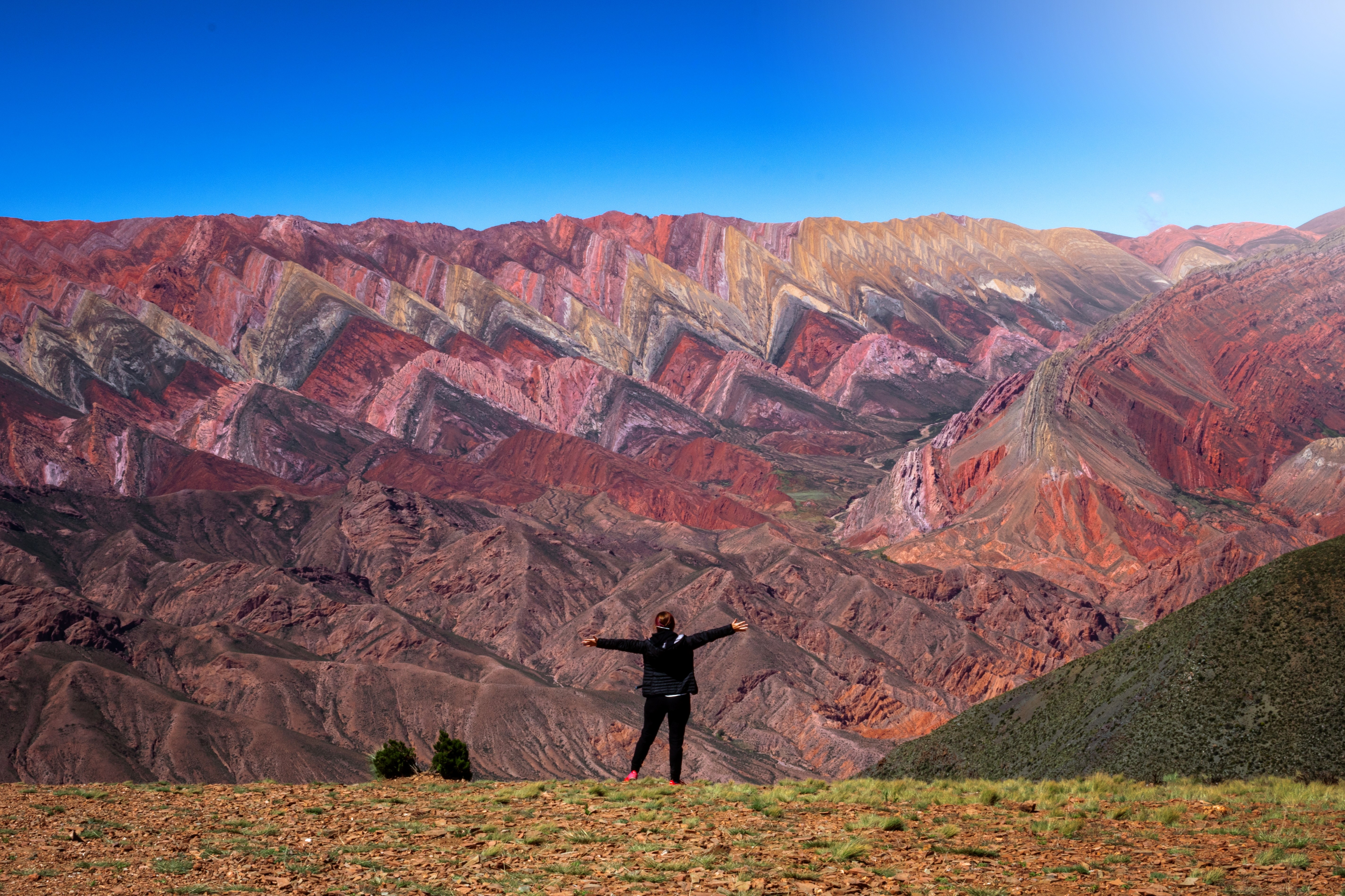
Quebrada de Humahuaca

A Rainbow Carved in Stone
The Quebrada de Humahuaca is a 155-kilometre valley of impossible colour — a narrow gorge carved through the Andes where mineral-streaked mountainsides blaze in seven, fourteen, and seemingly infinite shades of red, orange, violet, green, turquoise, and gold. Declared a UNESCO World Heritage Site in 2003 for both its natural beauty and its 10,000-year human history as a trade corridor linking the Andean highlands with the lowlands, the Quebrada follows the Río Grande northward through a landscape where every village, every hillside, and every turn in the road reveals a new explosion of geological colour. This was the great highway of the Inca Empire's southern frontier, and before that, a passage for cultures stretching back to the earliest human settlement in the Americas. Today, adobe villages with colonial churches sit beneath mountains that look painted by hand, indigenous Quechua and Aymara communities maintain traditions unchanged for centuries, and cardón cacti stand like sentinels along ridgelines glowing copper at sunset. From the seven-coloured hill of Purmamarca to the fourteen-coloured mountain of Hornocal, this drive is Argentina's most vivid — a route where geology becomes art.
Key Stops
San Salvador de Jujuy - The provincial capital and starting point. A pleasant Andean city at 1,260 metres with colonial architecture, good restaurants, and all services. Fill your tank here — fuel stations are scarce in the Quebrada. If arriving from Salta (190 km south), the drive through the green tobacco-growing lowlands offers a gentle introduction before the canyon country begins.
Volcán - The southern gateway to the Quebrada where the valley narrows and the colour palette begins to shift. The landscape transitions abruptly from subtropical green to arid canyon walls. You know you've entered the Quebrada when the mountains start revealing their striped geological layers.
Purmamarca — Cerro de los Siete Colores (Hill of Seven Colours) - The drive's first jaw-dropping moment, 65 km from Jujuy. This tiny adobe village sits at the foot of a mountain displaying seven distinct mineral bands — rose, cream, green, brown, red, purple, and ochre — created by millions of years of geological layering, with iron, copper, sulphur, and other minerals reacting with oxygen in the atmosphere. Walk the Paseo de los Colorados, a 3 km loop trail that circles behind the hill through an amphitheatre of red-rock formations. The village plaza hosts one of northwest Argentina's finest artisan markets, where indigenous weavers sell textiles, ceramics, and traditional crafts beneath ancient algarrobo trees. Stay overnight — the colours change dramatically with the shifting light.
Salinas Grandes Detour (via RN 52) - From Purmamarca, a spectacular side road (Ruta 52) climbs the Cuesta de Lipán through 2,000 metres of switchbacks to the Abra de Potrerillos pass (4,170 m), where herds of wild vicuñas graze at the roadside. The road then descends onto the Salinas Grandes — a vast, blinding-white salt flat at 3,450 metres stretching to the horizon. Local communities offer guided walks and salt-crystal harvesting demonstrations. The contrast between the Quebrada's colours and the salt flat's white infinity is staggering. Allow a full half-day for this detour. Note: the next fuel station beyond Purmamarca on this route is 200 km away in Susques — fill up in Jujuy beforehand.
Maimará — Paleta del Pintor (Painter's Palette) - Just 20 km north of Purmamarca, this small village is backed by a hillside known as the Painter's Palette — sweeping bands of colour running horizontally across the mountainside like watercolour washes. A 3-hour walk climbs to a viewpoint overlooking the entire formation. The village cemetery, set against the colourful hills, is one of the Quebrada's most photographed scenes.
Tilcara — Pucará de Tilcara - The Quebrada's liveliest town and an excellent base. The star attraction is the Pucará de Tilcara, a reconstructed pre-Inca fortress built by the Omaguaca people in the 12th century. This 15-acre hilltop citadel once housed 2,000 inhabitants and was later conquered by the Incas as a military outpost. Self-guided trails wind through stone walls, ceremonial platforms, and dwellings with commanding views over the valley. The town itself has the Quebrada's best selection of restaurants, craft shops, cafés, and accommodation. The Museo Arqueológico houses an excellent collection of regional artefacts. Tilcara's February Carnival celebrations are among the most vibrant indigenous festivals in Argentina.
Huacalera — Tropic of Capricorn - A tiny settlement where the Tropic of Capricorn crosses the road, marked by a massive sundial monument surrounded by colourful hills and farmland. Small craft markets sell local weavings and produce. Beyond its geographic novelty, Huacalera's colonial church contains notable paintings from the Cusco school.
Uquía — Angels with Guns - One of the Quebrada's most fascinating cultural stops. The 17th-century Iglesia de San Francisco de Paula (declared a National Historical Monument in 1941) houses the extraordinary "Ángeles Arcabuceros" paintings — angels depicted carrying muskets and wearing flamingo wings, brought from Cusco during the colonial period. These unique works blend Catholic iconography with indigenous Andean symbolism, created by indigenous artists sent to study in Cusco who returned blending the religious traditions. A small, quiet village that rewards those who stop.
Humahuaca - The town that gives the Quebrada its name and the northernmost major settlement. At 2,939 metres, this colonial town preserves adobe architecture, a central plaza with a striking monument to the heroes of Argentine independence, and a church where a mechanical figure of San Francisco Solano emerges at noon to give a blessing. Humahuaca is the base for two extraordinary excursions:
Serranía del Hornocal — The 14-Colour Mountain - The climactic natural wonder of the entire drive. A 25 km gravel road climbs east from Humahuaca (45-60 minutes) to a viewpoint at 4,350 metres overlooking a mountain formation displaying over 14 distinct colours in dramatic zigzag striations — rose, violet, green, white, ochre, red, brown, turquoise, gold. The geological layers date back over 500 million years. Arrive between 3:00 and 4:00 pm for the best light. The altitude is serious — acclimatise for at least a day before attempting this. Even sedans can manage the gravel road if driven slowly.
Iruya Detour - 26 km north of Humahuaca, Provincial Route 13 branches east on a dirt road that climbs to the Abra del Cóndor pass (4,000 m) before descending to the remote village of Iruya, clinging to a mountainside in a side canyon. The pre-Columbian architecture, winding stone paths, and total isolation make it feel like the end of the world. The drive is rough and spectacular. Allow a full day.
Driving Tips
- Altitude acclimatisation: The Quebrada ranges from 1,200 m to over 4,300 m. Spend your first night at a lower elevation (Purmamarca at 2,192 m or Tilcara at 2,461 m) before climbing to Hornocal (4,350 m). Drink coca tea, stay hydrated, eat lightly, and avoid alcohol on day one. Altitude sickness can impair driving judgement.
- Fuel strategy: Fill your tank in San Salvador de Jujuy before entering the Quebrada. The first fuel station within the canyon is in Tilcara, 25 km north of Purmamarca. If taking the Salinas Grandes detour, fuel up in Jujuy — the next station on that route is 200 km away in Susques. Never drive with less than half a tank.
- Road conditions: RN 9 through the Quebrada is paved and in good condition — wide, comfortable, and not vertiginous despite the canyon setting. Side roads to Hornocal, Iruya, and Salinas Grandes are unpaved gravel but manageable in a regular car if driven slowly and carefully.
- Police checkpoints: Expect frequent police roadblocks checking documents. The proximity to the Bolivian border means police vigilance is high. Keep your passport, driver's licence, and rental papers readily accessible. Observe speed limits — there are many police posts along the route.
- Offline maps: Download maps before departing. Mobile reception disappears once you leave town limits, especially on side roads to Hornocal and Iruya.
- Sun and temperature swings: Days are warm and sunny with intense UV at altitude — sunscreen, hat, and sunglasses are mandatory. Nights are cold, dropping below freezing in winter (June-August). Layer clothing. Desert-altitude sun can burn in minutes.
- Dry season (April-November): Roads are in their best condition and skies are clear. The wet season (December-March) brings afternoon thunderstorms that can cause flash floods and mudslides on unpaved roads, particularly the Iruya route.
- Photography light: The colours of the mountains change dramatically throughout the day. The Seven Colours hill at Purmamarca is best in early morning light. Hornocal's 14 colours peak between 3:00-4:00 pm. The Painter's Palette at Maimará glows at sunset. Plan your stops around the light.
- Cash: Carry Argentine pesos. Small villages, craft markets, and some fuel stations accept cash only. ATMs are available in Jujuy, Tilcara, and Humahuaca but may run out of cash on weekends.
- Carnival (February): If visiting during Carnival, expect road closures, crowded towns, and a spectacular indigenous celebration centred on Tilcara and Humahuaca. Book accommodation months in advance.
- Direction: Drive south to north from Jujuy to Humahuaca. This builds the colour intensity progressively — from the Seven Colours of Purmamarca through the Painter's Palette of Maimará to the Fourteen Colours of Hornocal. A natural crescendo.
- For more information visit: larutanatural.gob.ar/en/must-see/99/quebrada-de-humahuaca