Arches & the Upper Colorado River
Two Thousand Arches, One Ancient River
This two-part journey pairs the world's greatest concentration of natural stone arches with one of the American West's most dramatic river canyons. The route begins inside Arches National Park, where an 18-mile scenic drive climbs through a landscape that early explorers mistook for the ruins of an ancient civilization — over 2,000 named arches, along with towers, fins, balanced rocks, and formations resembling monumental chess pieces, all sculpted from salmon-colored Entrada sandstone over 300 million years. The road ends at Devils Garden, home to the impossibly thin Landscape Arch, the longest natural stone span in North America at 306 feet. From the park, the drive picks up Highway 128, the Upper Colorado River Scenic Byway, which follows the Colorado River northeast for 44.5 miles through a deep gorge of red Wingate sandstone. The river corridor has served as a backdrop for countless Hollywood films, and it's easy to see why — Castle Valley's sandstone towers, the 900-foot Fisher Towers, and the burnt remains of the 1916 Dewey Bridge create a landscape that seems designed for a widescreen lens.
Key Stops
Park Avenue The first major stop after the steep entrance road climb sets the tone for everything ahead. Towering sandstone walls rise on either side of a narrow canyon, their flat faces and vertical edges eerily resembling the skyscrapers of a city skyline. A one-mile trail descends into the canyon between these monoliths; the viewpoint alone is worth the stop if time is short. The Courthouse Towers — massive freestanding formations including the Three Gossips and Sheep Rock — stand just beyond.
Balanced Rock Nine miles from the entrance, a 55-foot boulder the size of three school buses perches atop a slender 73-foot pedestal, defying gravity and logic in equal measure. The combined height of 128 feet is visible from the road, and a short 0.3-mile paved loop circles the base for every angle. This is the turnoff point for The Windows section.
The Windows A short spur road leads to a cluster of massive arches — North Window (93 feet wide), South Window (105 feet), and Turret Arch (64 feet) set in a natural amphitheater of sandstone fins. The one-mile loop trail visits all three and is one of the park's most accessible and rewarding short hikes. A primitive trail loops behind the windows for a less crowded perspective, framing the La Sal Mountains through the openings.
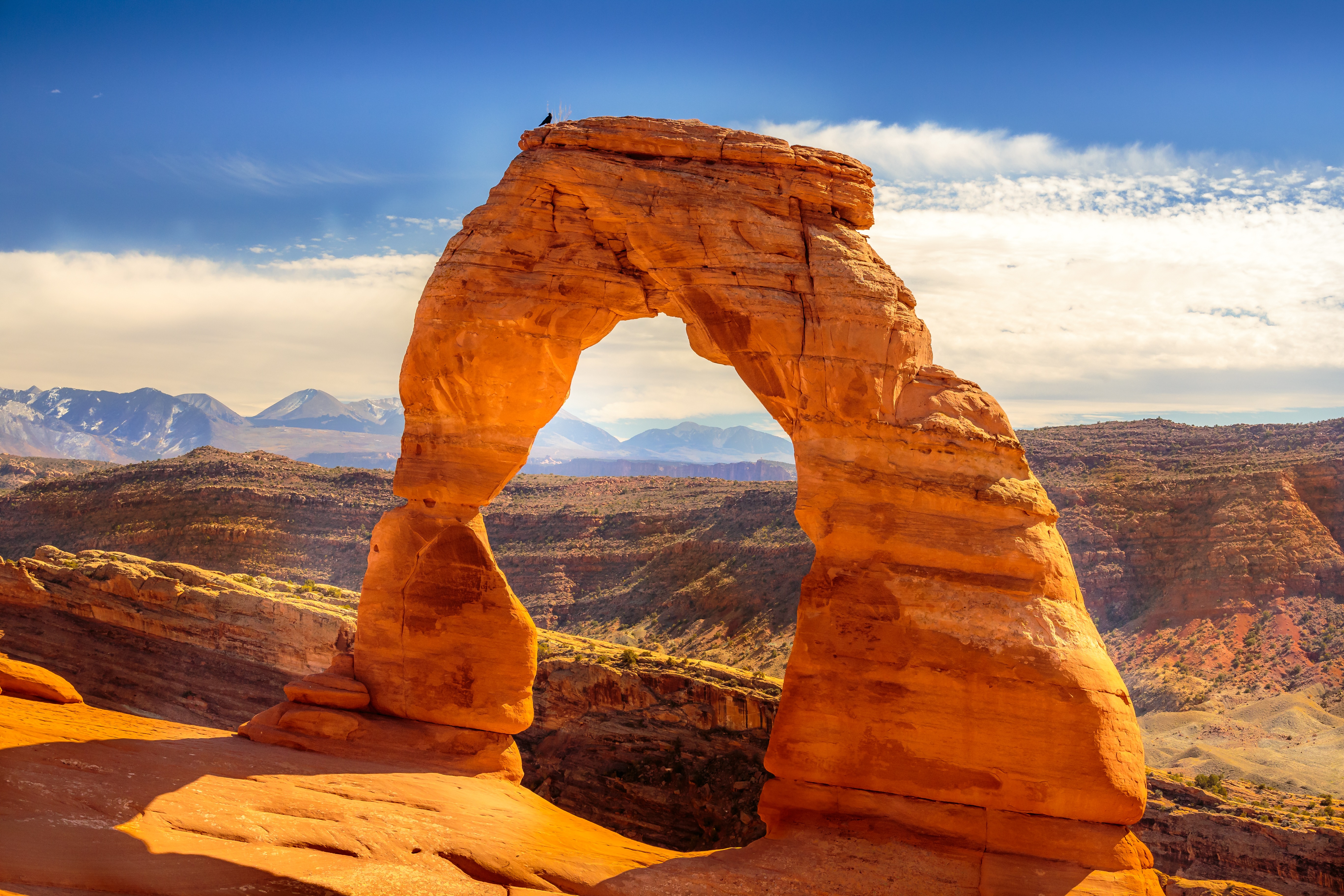
Delicate Arch Utah's most iconic formation and the image on the state license plate. The 3-mile round trip trail from Wolfe Ranch climbs 480 feet across open slickrock with no shade, cresting a sandstone ridge to reveal the freestanding 65-foot arch perfectly framing the La Sal Mountains. There is no preparing for the scale and isolation of the arch — it stands alone on the rim of a natural bowl, and the effect is quietly staggering. Arrive before 9:30 AM to find parking; carry plenty of water.
Fiery Furnace A labyrinth of narrow sandstone corridors, dead ends, and hidden arches that requires either a ranger-led tour ($16/person) or a self-guided permit ($10/person). There are no marked trails inside — navigation is by route-finding through a maze of fins and slots. Ranger-led tours are highly recommended and sell out months in advance on Recreation.gov.
Devils Garden The end of the scenic drive and the trailhead for the park's longest maintained trail. The first 1.6 miles lead to Landscape Arch, a 306-foot ribbon of sandstone so thin that slabs have fallen from its underside in recent decades — the trail beneath it was closed after a 1991 rockfall. The full 7.8-mile loop accesses seven named arches including Double O, Pine Tree, and the spire called Dark Angel. Beyond Landscape Arch, the trail becomes primitive with scrambling over fins and ledges.
Grandstaff Canyon Three miles east of Moab on Highway 128, this trailhead marks the start of a 4.65-mile round trip hike through a lush, stream-fed canyon of cottonwoods and hanging gardens to Morning Glory Natural Bridge — a 243-foot span and the sixth largest natural rock bridge in the United States. The canyon was renamed in 2017 to honor William Grandstaff, an African American prospector who settled in Moab in 1877. No fee or permit required.
Castle Valley A side road climbs south from the river into a valley of red-dirt ranchland set beneath a skyline of sandstone towers with the snow-capped La Sal Mountains rising behind. Castleton Tower — a 400-foot freestanding spire and world-famous rock climbing destination — dominates the scene. This valley has appeared in more Westerns, car commercials, and magazine covers than perhaps any other landscape in Utah. The road connects to the La Sal Mountain Loop for a scenic return to Moab.
Fisher Towers A 2.2-mile dirt spur leads to the trailhead for one of the most surreal hikes in canyon country. The 5.2-mile round trip trail weaves among dark red mudstone towers topped with harder Moenkopi caprock — the Titan, at 900 feet, is the tallest freestanding sandstone tower in the world. Metal ladders assist on exposed sections. The towers have a crumbling, almost molten appearance, as though they are slowly melting back into the desert. A small BLM campground at the trailhead has picnic tables and vault toilets but no water.
Colorado River Corridor For most of its 44.5 miles, Highway 128 hugs the Colorado River as it curves through a deep gorge of red and orange Wingate sandstone walls. Rafters float the Class I–III rapids of the Fisher Towers section (half-day trips from ~$130/person through Moab outfitters, May–September). Pullouts along the river offer access for fishing, picnicking, and photography. The Priest and Nuns — a cluster of sandstone spires on the canyon rim — and Professor Valley provide some of the most dramatic compositions along the route.
Dewey Bridge The original 1916 one-lane suspension bridge — the longest in Utah at the time — was destroyed by fire in April 2008. The steel towers and cables still stand as a haunting skeleton over the Colorado River, and interpretive signs tell the bridge's story. A modern replacement bridge carries traffic. Beyond Dewey Bridge, the canyon opens into wider desert as Highway 128 climbs toward its junction with I-70.
Driving Tips
- No timed entry: The park is first-come, first-served. Expect entrance waits of 30–45 minutes during peak season (March–October). Arrive before 7 AM or after 4 PM to avoid the worst congestion.
- Heat: Summer temperatures regularly exceed 100°F. The Delicate Arch trail has zero shade — carry at least one liter of water per person and wear sun protection. Spring and fall are far more comfortable for hiking.
- Highway 128: Fully paved and suitable for all vehicles including RVs. Watch for cyclists — this is a popular road biking route. Some pullouts are narrow; use caution when re-entering traffic.
- Fuel: Fill up in Moab. There are no gas stations inside Arches or along Highway 128 until I-70.
- Cell service: Limited inside Arches — some signal at the Visitor Center, Balanced Rock, and Panorama Point, but do not rely on it. Highway 128 has spotty coverage once past the first few miles. Download offline maps before departing.
- EV charging: Moab has approximately 29 charging stations including fast chargers at Lions Park (junction of Highway 128 and US-191) and a Tesla Supercharger. No charging inside the park or along Highway 128 beyond Lions Park.
- Dark skies: Arches is a certified International Dark Sky Park. Consider staying past sunset for exceptional stargazing — the Milky Way arching over the rock formations is unforgettable.
- Fiery Furnace: Ranger-led tours sell out months ahead on Recreation.gov. Book as soon as dates open if this is a priority.
- Flash floods: Avoid slot canyons and dry washes during rain. Summer monsoons (July–September) produce sudden, violent floods with little warning.
- For more information visit: Arches National Park (NPS)